Major Hurricane Eta nearing Category 5 Status

Major Hurricane Eta continues to rapidly intensify this evening, with the National Hurricane Center reporting Eta’s intensity at 150 mph as of the 9 pm CST update, with Category 5 intensity in the forecast. Eta is now officially the strongest hurricane of 2020, as well as the third strongest hurricane in the month of November on record, only behind The Great Cuba Hurricane of 1932 and Hurricane Lenny of 1999.
RECON was unable to reach Eta until the past hour, where an SFMR reported winds of 135 knots (155 mph), and that Eta continues to deepen in pressure.
The Forecast
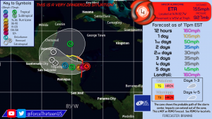
As of 10:00 pm CST on November 2, Major Hurricane Eta was located near 14.1°N 82.7°W, with maximum wind speeds of 155 mph and a minimum pressure of 927 millibars, moving WSW at 7 mph.
- A Hurricane Warning is currently in effect for the Nicaragua/Honduras border to Sandy Bay Sirpi.
- A Hurricane Watch is currently in effect for the northeastern coast of Honduras from Punta Patuca to the Nicaragua/Honduras border. A Tropical Storm Warning is in effect for the same area.
- A Tropical Storm Watch is currently in effect for the northern coast of Honduras from west of Punta Patuca westward to Punta Castilla.
Eta is expected to continue moving southwestward, and to continue intensifying until landfall tomorrow afternoon. Eta will move very slowly across Central America, delivering life-threatening flooding and rainfall in addition to sustained winds either approaching or beyond the Category 5 threshold of 157 mph. Much of Nicaragua and Honduras are forecast to receive 15-25 inches (380 to 635 mm), with isolated amounts of 35 inches (890 mm) possible. Areas as far as southeast Mexico could also see up to 15 inches. Storm surge is forecast to reach levels 14 to 21 feet above normal tide along the Nicaragua coast, and 3 to 5 feet above normal tide along the Honduras coast.
As catastrophic as the situation may be, there is hope that Eta’s intensity will plateau, as the National Hurricane Center notes that radar data suggests concentric eyewalls may be forming, which will lead to an eyewall replacement cycle, capping Eta’s intensity. Wind shear is also expected to slightly increase to 10-15 knots before landfall, which would assist in preventing Eta from strengthening further.
Eta’s long-range forecast remains uncertain, with models showing that either Eta or the remnants of Eta will move northeastward back over the Caribbean Sea this weekend, and potentially redevelop in the Caribbean Sea.
As tropical storm force winds and life-threatening rainfall have already begun moving onshore, the time to prepare and evacuate has passed, especially for areas along the coast. Citizens remaining in eastern Honduras/Nicaragua should follow the instructions provided by local officials, and go to a hurricane shelter if possible and safe to do so.
