Major Hurricane Ian Makes Landfall in Cuba, Set to Impact Florida

Major Hurricane Ian is set to continue intensification after its landfall and short land interaction over western Cuba. The storm’s eye emerged to the Gulf of Mexico as it is forecast to affect Florida, and make considerable damage on the Tampa Bay Area.
LATEST INFORMATION
On the 8AM EST advisory of the National Hurricane Center, Major Hurricane Ian was last located at 22.3°N 83.7°W, or about 10 miles (15 km) north-northeast of the City of Piñar del Rio, Cuba, or about 130 miles (240 km) south-southwest of Dry Tortugas, Florida. The storm packs 1-minute sustained winds of 125 mph (205 kph / 110 kts) and gusts reaching up to 155 mph (250 kph / 135 kts.) The storm was estimated to have a minimum central pressure of 952 millibars and is moving north at a speed of 12 mph (19 kph / 10 kts.)
CURRENT WARNINGS
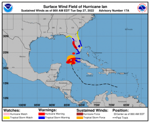
Hurricane Warning is issued over the Cuban provinces of Isla de Juventud, Pinar del Rio, and Artemisa; Bonita Beach to the Anclote River, including Tampa Bay, and Dry Tortugas in Florida.
Storm Surge Warning is hoisted over Anclote River southward to Flamingo and Tampa Bay
Hurricane Watch is issued over North of Anclote River to the Suwannee River
Storm Surge Watch is issued over the Florida Keys from the Card Sound Bridge westward to Key West, Dry Tortugas, Florida Bay, Aucilla River to Anclote River, Altamaha Sound to Flagler/Volusia County Line, and the Saint Johns River
Tropical Storm Warning is hoisted over the Cuban provinces of La Habana, Mayabeque, and Matanzas, Lower Florida Keys from Seven Mile Bridge westward to Key West, Flamingo to Bonita Beach, Suwannee River to the Anclote River, Volusia/Brevard County Line south to Jupiter Inlet, and Lake Okeechobee.
Tropical Storm Watch is in effect north of the Suwannee River to Indian Pass, Altamaha Sound to Volusia/Brevard County line, and Deerfield Beach to Jupiter Inlet.

WHAT TO EXPECT?
TRACK AND INTENSITY: Major Hurricane Ian is forecast to slightly intensify in the southeastern Gulf of Mexico at 145 mph (120 kts / 230 kph) tomorrow. After this intensification, the storm is expected to slowly weaken up until its landfall over the Tampa Bay Area on Thursday morning.
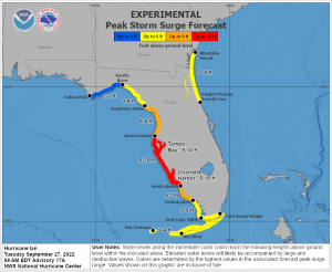
STORM SURGE: Central Florida, including the Tampa Bay area is forecast to experience storm surge up to 10 feet. Other parts of the state could experience anywhere from 1 to 8 feet of storm surge. These storm surges could cause coastal inundation and flooding.
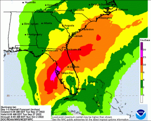
RAINFALL: Six inches up to a foot of rainfall is still forecast over Western Cuba as the storm rainbands continue to affect the island. In the Central portion of Florida, totals of up to 16 inches are forecast. And in the rest of the state, rain gauges could still measure up to 10 inches. This amount of rainfall will cause widespread flooding and rivers overflowing.
WIND: Hurricane-force winds over western Cuba are still expected Tuesday, strength of these winds should reduce as the Ian moves north. Floridian west coast up to Central Florida is forecast to experience gale-force winds tonight and hurricane-force winds starting Wednesday morning. These winds could destroy homes, uproot trees, and take down electric poles.
TORNADOES: As the storm moves over the Southeastern United States, tornadoes could form on Wednesday morning.
Please heed the evacuation on several counties across the State of Florida and for more information, go to https://www.floridadisaster.org/evacuation-orders/. For more localized forecast you can refer to NWS Offices across the state like NWS Key West (https://www.weather.gov/key/), NWS Tampa Bay (https://www.weather.gov/tbw/), NWS Miami (https://www.weather.gov/mfl/), NWS Tallahassee (https://www.weather.gov/tae/), and NWS Jacksonville (https://www.weather.gov/jax/).
