Major Hurricane Ian to Bring Catastrophic Damage to Florida

Major Hurricane Ian is inching closer to Florida’s southwestern coast and is set to bring catastrophic damage to millions of people living in the Sunshine State. The National Hurricane Center describes the effect to be “catastrophic” and “life-threatening”.

LATEST INFORMATION
The National Hurricane Center 10AM update on Major Hurricane Ian states the storm is located at 26.2°N 82.7°W, or about 60 miles (95 km) west of Naples, Florida, or about 65 miles (105 km) southwest of Punta Gordo, Florida. The reconnaissance mission flying over the storm, as of the writing, finds the storm to have maximum 1-minute sustained winds of 155 mph (135 kts / 250 kph) with gusts reaching up to 190 mph (165 kt / 305 kph.) The reconnaissance mission also found out the storm’s minimum central pressure is 937 millibars and is moving towards north-northeast at a speed of 10 mph (9 kts / 17 kph.)
CURRENT WARNINGS
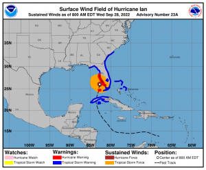
Hurricane Warning is in effect over Chokoloskee to Anclote River, including Tampa Bay, and Dry Tortugas.
Storm Surge Warning is hoisted over Suwannee River southward to Flamingo, Tampa Bay, Lower Florida Keys from Big Pine Key westward to Key West, Dry Tortugas, Flagler/Volusia Line to the mouth of the St. Mary’s River, and St. Johns River.
Tropical Storm Warning is in raised over the Cuban provinces of La Habana, Mayabeque, and Matanzas, Indian Pass to the Anclote River, all of the Florida Keys, Flamingo to South Santee River, Flamingo to Chokoloskee, Lake Okeechobee, Florida Bay, and Bimini and Grand Bahama Islands.
Storm Surge Watch is in effect over Florida Keys from the Card Sound Bridge westward to east of Big, Pine Key, Florida Bay, and the mouth of St. Mary’s River to South Santee River.
WHAT TO EXPECT?
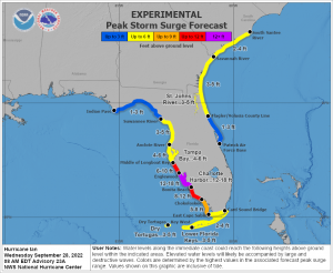
STORM SURGE: The combination of storm surge and tide will cause coastal areas to be flooded by the rising waters brought by the storm. Storm surge of up to 18 feet is forecast by the NHC from Englewood to Bonita Beach, and the Charlotte Harbor— that is almost two-stories high if you have a house next to a coast. Storm surges in other parts of the Florida west coast are still life-threatening and could see up to 12 feet.
WINDS: Tropical Storm conditions are currently being felt over central and southwestern Florida, with Hurricane winds coming from the coast as the storms approach Florida Peninsula. These winds can severely damage infrastructures like homes and office buildings, uproot trees, and take down electric poles that could prevent any vehicles trying to get out of the storm.
RAIN: Totals of up to 18 inches, with local totals up to 24 inches are forecast for central and northeastern Florida, including Fort Myers, Tampa, and Orlando. The Florida Keys, south Florida, eastern Georgia, and coastal South Carolina could receive as much as 8 inches of rain. These amount of rain is likely to cause flash flooding and coastal flooding especially those that would receive at least a foot of rain. Combined with storm surge, coastal areas are likely to experience higher flood.
TORNADOES: Formation and landfall of tornadoes across central Florida is possible, bringing additional damage to areas to be affected.
Please follow all orders of the local government if you still haven’t. Time has run out to do any significant preparation to the storm, and brace for catastrophic landfall. Force Thirteen hopes everyone that will be affected by the storm will be safe as the storm passes through the state. You can also watch the live landfall coverage of Ian here:
