March’s Severe Weather train continues into April

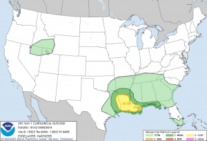
The March craziness of severe weather is continuing into April, with 3 days of severe weather across the south once again, with potentially more on the way. With a storm system tracking across the US bringing severe weather to the south and some snow to the northeast, the Storm Prediction Center has issued Slight Risks back to back from Thursday through the weekend. For Thursday, a slight risk has been issued, which comes with a 5% chance of a tornado, and a 15% chance of wind/hail for Thursday’s event across Louisiana & extreme eastern Texas. The SPC has put southern Louisiana under a 40% chance of being under a severe thunderstorm watch.
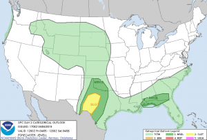
For Friday, Western Texas is going to be the area of greatest concern. Wind and hail are forecast to be the main event with a 15% Chance, though a brief tornado is also possible. The SPC is highlighting a high area of instability over a large area, so there is a chance that severe storms could fire up farther west than forecasted.
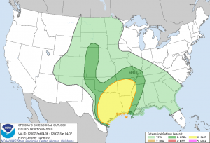
Saturday is the day that needs to be watched closely. A majority of the central southern states is forecast to receive severe weather, with a few severe storms possible across the western plains. There is massive uncertainty what will occur, and where. For now, the SPC is highlighting all threats, tornadoes, wind, and hail, as the events for Saturday, and is probably going to be extremely complex to forecast.
As we enter April and May, which is peak tornado season, stay tuned to the Force Thirteen US channel for updates and livestreams covering all weather US-related.
