Megi Brings Flooding to Leyte, Malakas Steadily Intensifies

Tropical Storms Megi (Local Name: Agaton) and Malakas, the first two named systems in the Western Pacific have presented some early season challenges. Tropical Storm Megi has been pounding the Eastern provinces of central Philippines since last week as Tropical Storm Malakas has continued its slow intensification near the Federal State of Micronesia.
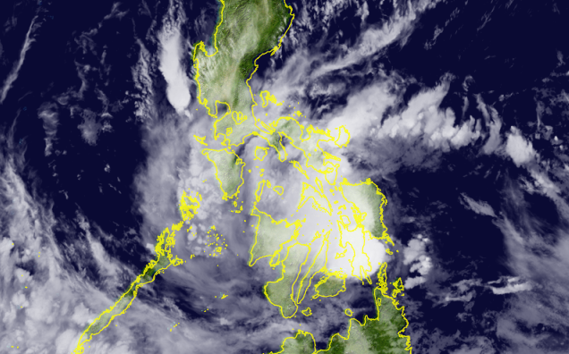
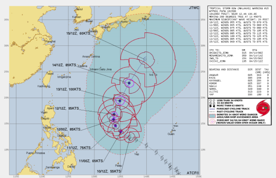
Based on the PAGASA advisory issued on 8PM PhST, Megi was located at 10.8N 125.0E or in the vicinity of MacArthur town, Leyte with 10-minute winds of 75 kph, gusting up to 105 kph, with minimum central pressure of 998 millibars. Malakas meanwhile, based on ATCF update on 8PM PhST, it was located 12.4N 136.8E or about 350 kilometers north-northwest of Colonia, Federal State of Micronesia; or 580 kilometers north-northeast of Palau; or 1,215 kilometers east-northeast of Guiuan, Eastern Samar. It has 1-minute winds of 100 kph and has minimum central pressure of 985 millibars.
Current Warnings:
For Tropical Storm Megi (Local Name: Agaton)
(Tropical Cyclone Bulletin No. 14 issued April 10, 2022 8:00PM PhST)
Tropical Cyclone Wind Signal No. 2
(Gale-force winds prevailing or expected in the next 36 hours)
- Central and Southern portions of Samar Island
- Biliran
- Northern and Central portions of Leyte Province
- Northern portion of Dinagat Islands
Tropical Cyclone Wind Signal No. 1
(Strong winds prevailing or expected in the next 36 hours)
- Southern portion of Masbate
- Rest of Samar Island
- Rest of Leyte Province
- Southern Leyte
- Northeastern portion of Cebu including Camotes Islands
- Eastern portion of Bohol
- Rest of Dinagat Island
- Surigao del Norte
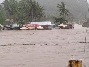
Due to the slow and erratic movement of Tropical Storm Megi, high-end flooding events were reported in several parts of the country. The National Disaster Risk Reduction and Management Council has reported 67 flooding events. A total of 38,399 families have been affected across four regions. The agency also reported a fatality due to the storm, with the validation process still ongoing; two confirmed casualties, and an unconfirmed missing person. There was also a report of a ship capsizing in Eastern Visayas, luckily all aboard were confirmed safe. Other local reports of missing persons haven’t been reflected on NDRRMC’s Situational Report. PAGASA and NDRRMC warn moderate to heavy rains will continue until Monday and flooding events and landslides could still happen in disaster-prone areas.
Tropical Storm Megi is forecast to continue its erratic movement over Eastern Visayas due to the weak steering environment. By Tuesday afternoon or evening, Megi will move eastward as it is expected to have binary interaction (Fujiwhara Effect) with Tropical Storm Malakas. At this point Tropical Storm Malakas is likely to have entered the Philippine Area of Responsibility and would be named “Basyang” by PAGASA. Forecast to be the more dominant storm, Malakas is expected to absorb Megi and continue to Intensify. It will then move north to north-northeast and exit PAR by Wednesday and continue moving north-northeast towards the direction of the Ogasawara Islands of Japan.
Please observe precautions, and follow local orders of evacuation. See more information on PAGASA for more local weather forecasts.
