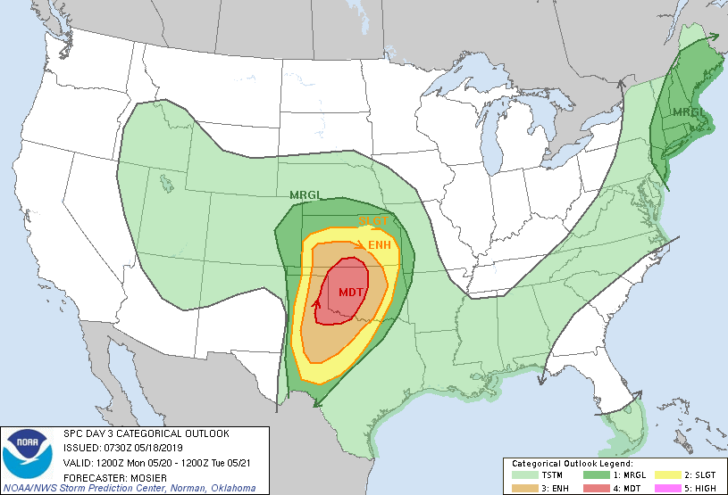
Moderate Risk across Tornado Alley Monday

We are now reaching the peak of tornado season, and that is very evident with a Moderate Risk across Oklahoma and Texas for Monday. All modes of severe weather are forecast on this day, and a significant tornado outbreak is extremely likely. While it has not been issued yet, High risk issuance is entirely possible tomorrow or Monday.
No factors are limiting severe thunderstorm development on Monday. CAPE values are around 4-5,000 J/kg, wind shear is going to be incredibly high, though there is still some uncertainty in where the strongest storms will occur. As such, the SPC has given a rather large Moderate risk for North central Texas and central Oklahoma.
Tornado Threat
It appears Tornadoes, probably significant (EF2+), will be the star of the show for Monday. Storms should initiate after 4 PM CDT, and explosively grow in size and strength. We can’t say where the highest tornado threat will exactly be, but we can say with high certainty, strong tornadoes can be expected Monday.
Damaging Winds
Damaging winds are also likely, though they will likely be the dominant feature across New Mexico, and even up around New York City. Significant wind events, maybe a derecho, is likely across the Enhanced risk and above areas.
Significant Hail
Teacup size hail (3 inches) is very large, and is also likely across the area. Larger hail sizes are also possible. Hail will probably be the dominant factor over wind.
To summarize… a significant severe weather event is expected across Texas and Oklahoma, and High Risk issuance, in my opinion, is likely. Where it will be, we cannot say exactly. All modes of severe weather, probably with significant parameters, are likely Monday
Stay tuned to Force Thirteen US for severe weather updates on the Enhanced risk tonight, and the Moderate risk Monday. A live event will occur Monday.
