More Severe Thunderstorms for the US this week
While there is a fair amount of uncertainty on Wednesday, there is evidence to support a severe weather event occurring in southern Texas, all modes of severe weather look to be possible, though the exact threat area and the level of these threats remain uncertain.
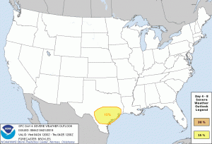 While the US has had numerous severe thunderstorms over the past couple of weeks, activity is expected to remain relatively active over the next few weeks, with the next concerning period regarding severe weather occurring on Wednesday. Although four days out, the Storm Prediction Center(SPC) has a fair amount of confidence in an event occurring in southern Texas. While probabilities are still at 15% for Wednesday on the severe weather front as can be seen on the graphic above, the SPC also is keeping an eye on Thursday saying “potential for severe storms will exist. However, deep-layer shear is forecast to be on the weak side which introduces too much uncertainty to introduce a slight risk at this time.”(Valid as of 0644z). While at this time it can not be said that an outbreak of severe weather will occur, there is relatively high confidence that a multi-day severe weather event will occur mid-late next week. Friday also looks to have severe potential although uncertainty skyrockets and there is not enough agreement to say chances or modes of severe weather at this time.
More Detailed Look on Wednesday(Valid 06z Wednesday-06z Thursday):
There is a good agreement from all models(NAM, GFS, GFS-FV3, GDPS, ECMWF) that a long line of thunderstorms extending from the south-central border of Texas to central Oklahoma will be present at 06z Wednesday, while there will be no substantial threat of severe weather at this time a couple of isolated severe thunderstorms in central and southern Texas cannot be ruled out given CAPE values at the time of up to 1,000 J/kg are possible. While there is significant disagreement uppon models at this point it is clear that favorability for severe thunderstorms will increase significantly in southern Texas as the line of thunderstorms grows more concentrated on south-central Texas around 12z, with favorable CAPE, and wind shear for isolated severe thunderstorms and tornadoes. There is a relatively good agreement that this line will advance to from south-eastern to south-central Texas by 18z, with severe potential being high on the southern part of the line, with CAPE around 2,000 J/kg possible and wind shear supportive of supercell development. Uncertainty goes up greatly after this point as the GFS-FV3 shows signs of a bow echo forming, the GDPS shows a disorganized blob of storms, the GFS does as well. What can be concluded is that by the end of the forecast period a substantiated low-pressure system will be established with the line of strong storms on the Texas-Louisiana border.
Conclusion:
While there is a fair amount of uncertainty on Wednesday, there is evidence to support a severe weather event occurring in southern Texas, all modes of severe weather look to be possible, though the exact threat area and the level of these threats remain uncertain.
