Cyclone Belal a threat to Réunion, Mauritius
Cyclone Belal is now a severe tropical storm according to Météo-France La Réunion, as it starts to rapidly intensify on approach to the Mascarene Islands, where a powerful landfall is expected over Réunion by Monday afternoon.
Current information
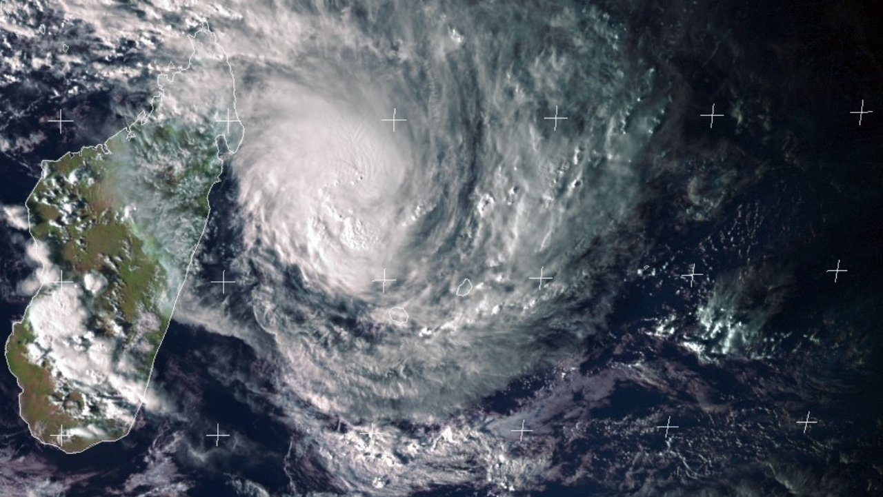
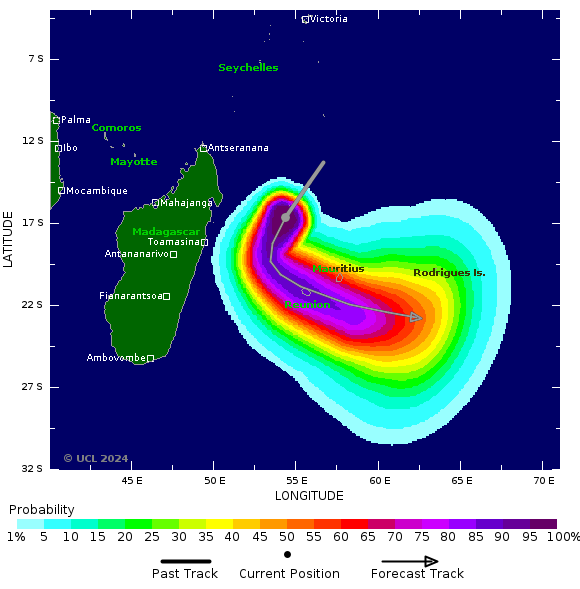
As of 16:00 RET (12:00 UTC), Belal is located near 16.8 degrees south, 54.0 degrees east, or approximately 475 km (295 mi) to the north-northwest of Réunion, and 520 km (323 mi) to the north-northwest of Mauritius. It is currently moving southwest at 24 km/h (15 mph).
Belal is rapidly intensifying according to the the Météo-France La Réunion (MFR), as it rapidly developed a central dense overcast with cold cloud tops, along with strong lightning activity being reported. The MFR has estimated Belal to have 10-minute sustained winds of 100 km/h (65 mph), with gusts up to 150 km/h (90 mph), and a central pressure of 986 hectopascals. The Joint Typhoon Warning Center (JTWC) has Belal with 1-minute sustained winds of 100 km/h, a tropical storm on the Saffir-Simpson scale.
Current warnings
As of this writing, a yellow cyclone pre-alert is currently in effect for Réunion, and a class I cyclone warning for Mauritius.
Current forecast
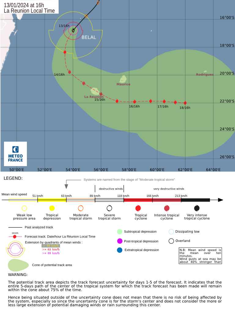
Under an environment of 30-31°C sea surface temperatures, little to no shear and excellent upper-level divergence, Belal is forecast to continue rapidly intensifying in the next 36 hours to attain a peak intensity of 200 km/h (125 mph) by Monday morning, an intense tropical cyclone, according to the MFR. The JTWC’s forecasted peak intensity is slightly low from the MFR forecast, with 195 km/h (120 mph), a category 3-equivalent tropical cyclone on the Saffir-Simpson scale. As it reaches that peak intensity, it is expected to turn to the southeast as the westerlies over Madagscar weaken the deep-layered subtropical ridge to the east of the system. Both the MFR and JTWC agree on a Réunion landfall by Monday night, although the former has noted the uncertainty that the cyclone may pass within 100–150 km of the island.
Afterwards, the system is forecast by the JTWC to continue on a southeast direction as the subtropical ridge reorients to the northeast of the system; however, there is potential for Belal to slow down as the subtropical ridge builds back, creating a competing steering environment between a ridge to the west, and leads to some uncertainty in the coming week.
Current hazards
In Réunion, the MFR has alerted that gale-force winds will start to be felt from Sunday evening, and hurricane-force winds by Monday. Heavy rainfall is also expected in the next 24 hours, with 200–400mm (8–16 in) over the lower areas of the island and 1,000–1,500mm (39–59 in) over higher grounds from Sunday evening until Monday when Belal is expected to make landfall.
In Mauritius & Rodrigues, the following information is from our partners at MeteoHub – Mauritius:
- Today, 13/01: External cloud bands associated with the system will cross the island during the day and tonight. Rainy periods are expected. There will be gusts of 60-70 mph below the rain.
- Sunday 14/01: The weather will remains cloudy with rainy periods. Showers will be moderate to strong at times with thunderstorms and gusts of 80 to 90 km/h per moment.
- In Rodrigues, clouds associated with the system will cause showers, with thunderstorms and gusts of 50-70 km/h, interrupted by temporary calming. Showers will be moderate to strong at times with thunderstorms. Some water accumulation is possible.
- Monday 15/01: The weather will remain heavily rainy and windy. Rainfall will cause water accumulation and flooding. Gusts will be dangerous for trees, infrastructure and fragile housing especially at night. Cyclonic conditions (gusts in excess of 120 km/h) are possible overnight into Tuesday morning.
