Cyclone Biparjoy has intensified into an Extremely Severe Cyclone this morning, becoming the 2nd Extremely Severe Cyclone of the 2023 North Indian Ocean Cyclone Season. Biparjoy continues to move northward, inching closer to the Gujarat-Pakistan border where, two decades ago, the 1999 Karachi Cyclone and 1998 Gujarat Cyclone made landfall -two of the deadliest cyclones ever to strike the region.
Current Information
According to the Indian Meteorological Department’s (IMD) 11:30 AM IST (6:00 AM UTC) Update, Extremely Severe Cyclone “Biparjoy” is located at 18.2°N, 67.7°E. The storm continues to move northward and located at a distance of 460 km from Porbandar, Gujarat of India.
Extremely Severe Cyclone Biparjoy has 3 minutes sustained winds equivalent to 105 mph (90 Kts/165 Kph) gusting up to 125 mph (110 Kts/210 Kph) and a minimal center pressure of 966 millibars. The system is currently moving Northward with a speed of 5 mph (4 Kts/8 Kph)
At 12PM UTC, the Force Thirteen Cyclone Analyst team analyzed the system a bit higher with 1 minute sustained winds equivalent to 115 mph (100 Kts/185 Kph) and a minimal central pressure of 949 mb based on the satellite appearance, putting the storm as a weak Category 3 cyclone.
In Depth Look
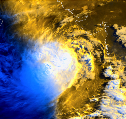
Currently Extremely Severe Cyclone Biparjoy is present in the north Central Arabian Sea. Cyclone Biparjoy is currently located in a marginal favorable region for intensification with high vertical wind shear off set by warm Sea Surface temperature of 30-31°C.
Analysis of model soundings shows Biparjoy will continue to remain in moderate easterly shear. Microwave imagery depicts reformation of an eyewall structure in Biparjoy which suggests the storm is on the mend from an eyewall replacement cycle.
Biparjoy is expected to maintain its peak for some more hours and could further intensify marginally. After that it will encounter unfavorable conditions. A sea of dry air, moderate to high shear, relatively colder SST, decreased outflow will weaken the system steadily. From Wednesday, Biparjoy will turn Northeastward as it will round the sub-tropical ridge to the east and is projected to make landfall as a Very Severe Cyclone near Jakhau port of Gujarat, India on at mid day of June 15th.
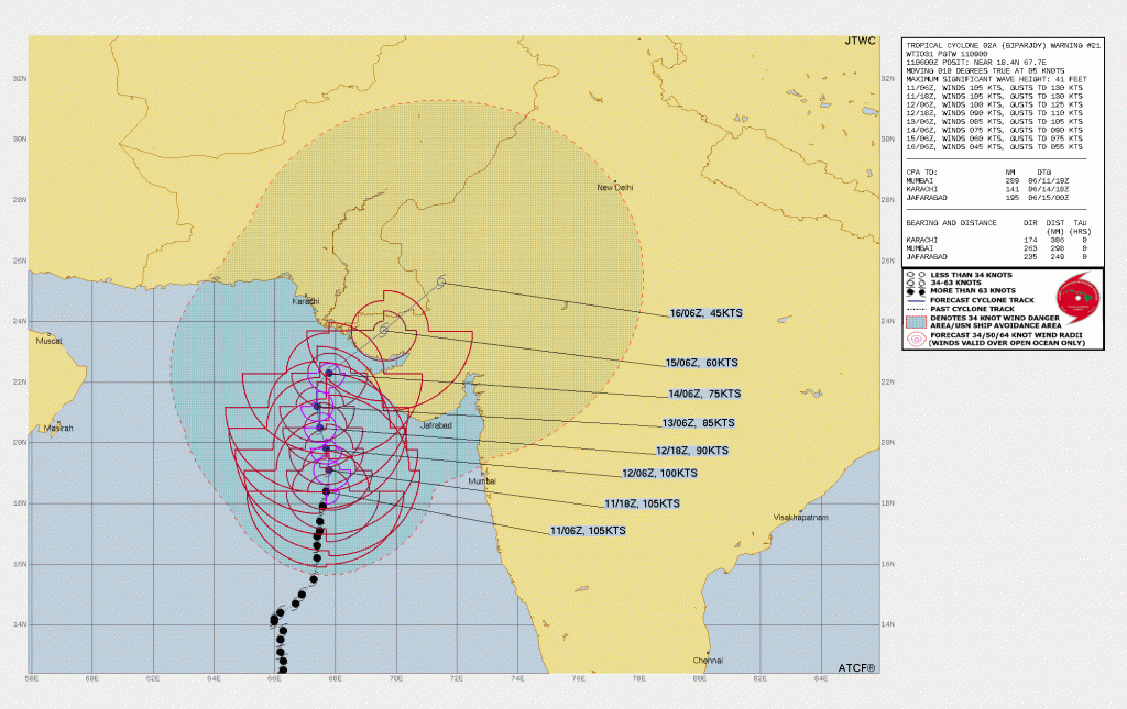
Latest Joint Typhoon Warning Center cone on Cyclone Biparjoy showcasing a large cone of uncertainty for the storm’s eventual landfall somewhere on the western coast of India later this week.
Cyclone Effects
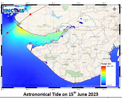
India Meteorological Department Storm Surge Warning forecast for Biparjoy as current landfall indications suggest.
Wind & Rain – Wind & Rain – As Cyclone Biparjoy is expected to make landfall in Kutch, near the Indus Delta, by June 15th, Gale force winds are expected to batter the Gujarat and Sindh coasts from June 12th through to June 17th, with hurricane-force winds over parts of the Kutch peninsula on June 15th. Those winds will be further accompanied by heavy to extremely heavy rains at isolated places (more than 200 mm). Very heavy rain rates can cause major flash flooding in those areas. Rainfall total can even peak 750 mm in the Southern side of the cyclone where the major bulk of the convection is.
Wind & Rain Warning by Indian Meteorological Department
Storm Surge – Due to the topographical feature of the delta region, filled with narrow creek storm surge of 3-4 meter has been forecasted in the deltaic & low lying part of Indus river and Kutch region during landfall.
Fisherman and Port Warnings:
In the wake of the Cyclone landfall, the respected meteorological agencies has advised total suspension of fishing, tourism and other on and offshore activities over Gujarat and Pakistan Coast. Citizens are advised to remain indoors in the coastal areas.
Preparedness
Pakistan’s National Disaster Management Authority (NDMA) has urged the people of Karachi to exercise extreme caution as Extremely Severe Cyclone Biparjoy has inched closer to Karachi. Pakistan’s Prime Minister Shehbaz Sharif has ordered officials to put in place emergency measures in advance for Cyclone Biparjoy in the Arabian Sea that is likely to cause flooding and rainstorms in low-lying areas of Karachi and Sindh province. The Gujarat government shutdown popular sea beaches like Chowpaty in Porbandar, Shivrajpur near Dwarka in Devbhumi Dwarka, and Mandvi in the Kutch district.
While the Chief Minister of Gujarat reviews the preparedness of coastal districts of the state against possible cyclones. He has announced to postpone the school enrollment drive Shala Praveshotsav in six coastal districts of Dwarika, Porbandar, Kutch, Morbi, Jamnagar and Junagadh for the time being. In other districts of the state, this school enrolment drive will now be held on two days i.e. June 12 and 13 instead of three.
Records
Extremely Severe Cyclone Biparjoy has become the 2nd Major Cyclone in the 2023 Pre-Monsoon Cyclone Season, a feat only accomplished in the 2019 and 1963 pre monsoon Cyclone Season. In addition, Biparjoy is also the 2nd Extremely Severe Cyclone of the 2023 Pre monsoon cyclone season tied with 1963 and 1982. The current forecast from JTWC suggests that Biparjoy can break both the single TC ACE record of NIO(2019 Kyarr, 24.715), and the NIO spring season ACE record set by Fani and Vayu in 2019.
Cookies help us ensure our site works securely, continually make improvements, and personalize your browsing experience.
Click 'Accept All Cookies' to get the best browsing experience. You can change these settings at any time by clicking 'Manage My Cookies' below.
Functional Always active
The technical storage or access is strictly necessary for the legitimate purpose of enabling the use of a specific service explicitly requested by the subscriber or user, or for the sole purpose of carrying out the transmission of a communication over an electronic communications network.
Preferences
The technical storage or access is necessary for the legitimate purpose of storing preferences that are not requested by the subscriber or user.
Statistics
The technical storage or access that is used exclusively for statistical purposes.The technical storage or access that is used exclusively for anonymous statistical purposes. Without a subpoena, voluntary compliance on the part of your Internet Service Provider, or additional records from a third party, information stored or retrieved for this purpose alone cannot usually be used to identify you.
Marketing
The technical storage or access is required to create user profiles to send advertising, or to track the user on a website or across several websites for similar marketing purposes.