Cyclone Jasper to strike Queensland tomorrow
Cyclone Jasper has been losing its deep convection from earlier today, but is expected to reintensify as it looks to make landfall on the Cape York Peninsula by tomorrow afternoon local time.
Current information
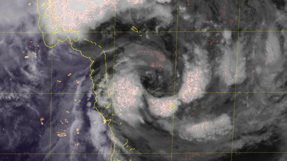
As of 22:00 AEST (12:00 UTC), Cyclone Jasper is located near 15.7 degrees south, and 147.4 degrees east, or about 220 kilometres (137 mi) to the northeast of Cairns in Queensland, Australia. It is currently moving northwest at 7 km/h (5 mph).
The Australian Bureau of Meteorology (BoM) has estimated Jasper to have 10-minute sustained winds of 85 km/h (50 mph), thus a Category 1 on the Australian scale, with gusts up to 120 km/h (75 mph), and a central pressure of 990 millibars. The Joint Typhoon Warning Center (JTWC) has Jasper with 1-minute sustained winds of 90 km/h (60 mph), and a central pressure of 988 millibars. Both estimates are backed up by Dvorak and surface observations, although its deep convection is decreasing.
Jasper is currently in an environment of very low wind shear, and remains in warm sea surface temperatures. Although its convection is decreasing due to the continued effects of a dry air intrusion, it is expected to come back tomorrow with the peak diurnal period.
Current warnings
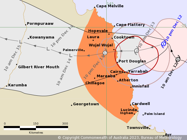
A Cyclone Warning is currently in effect for Cape Melville to Lucinda, including Cairns and Innisfail and extending inland to include Chillagoe and Palmerville. Additionally, a Flood Watch is also in effect for the North Tropical Coast, parts of the Cape York Peninsula and Gulf Country.
Current forecast
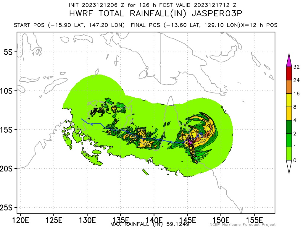
Within a favorable environment, Jasper is forecast to reintensify once again to a Category 2 system, as it takes a more westerly track due to the influence of a ridge to its south, before it makes landfall between Cooktown and Port Douglas by tomorrow afternoon. After landfall, land interaction and dry air will rapidly weaken Jasper and likely dissipate by Thursday. Its remnants is forecast to emerge to the Gulf of Carpentaria by Saturday, where the BoM expects regeneration by next week.
Ads by 
Current hazards
-
Locally intense rainfall which may lead to dangerous and life-threatening flash flooding is forecast to develop from Wednesday afternoon along the coast and adjacent ranges between Cape Flattery and Port Douglas as well as areas near the centre of Jasper. Isolated six-hourly rainfall totals between 250–300mm are likely with 24-hourly totals between 400–500mm possible.
Heavy rainfall which may lead to flash flooding is also forecast to develop between Cape Flattery and Ingham. Six-hourly rainfall totals between 100–150mm are likely, with isolated falls up to 250mm along the coast and adjacent ranges. 24-hourly rainfall totals between 150–250 mm are likely, with isolated falls up to 350mm possible.
- Destructive wind gusts of up to 140 km/h may develop between Wujal Wujal and Innisfail, including Cairns from early Wednesday morning.
Gales with damaging wind gusts of up to 120 km/h are expected to develop along the Queensland coast and adjacent ranges between Cape Flattery and Lucinda, including Cairns late Tuesday or early Wednesday. These damaging winds are likely to extend inland as far as Palmerville and Chillagoe after the cyclone has crossed the coast on Wednesday. Gales with damaging winds may extend as far north as Cape Melville on Wednesday, depending on the movement of Jasper.
-
As the cyclone approaches the coast, a storm tide is expected between Cooktown and Lucinda on the high tides on Wednesday. Large waves may produce minor flooding along the foreshore.
According to 9News, locals well-accustomed to cyclones have been preparing for days, clearing debris and loose items, filling sandbags and yesterday stripping supermarket shelves in Cairns. About 25,000 people in the red and orange flood zones were told to prepare to leave and plan to stay with friends or family on higher ground. Evacuation centres were also set up at the Edmonton Storm Tide Cyclone Shelter and Redlynch State College. Emergency alerts were issued yesterday for Douglas Shire, where residents were urged to take shelter in the strongest part of the building they were in, and Wujal Wujal.
A pre-emptive disaster declaration was made yesterday for the area between Cape Melville and Townsville, as emergency response teams flew in from Brisbane.
As the system closes in to the state of Queensland, it is important to stay updated with your local officials to know what you will do once the cyclone hits. Preparations should be nearing completion. Evacuate if ordered to, and have plenty of non-perishable food stocked up. Stay tuned to your local weather office, and to our Australian regional channel and 24/7 automated stream as the system progresses.