Cyclone Mocha Set to Bring Extensive Damage to Myanmar and Bangladesh
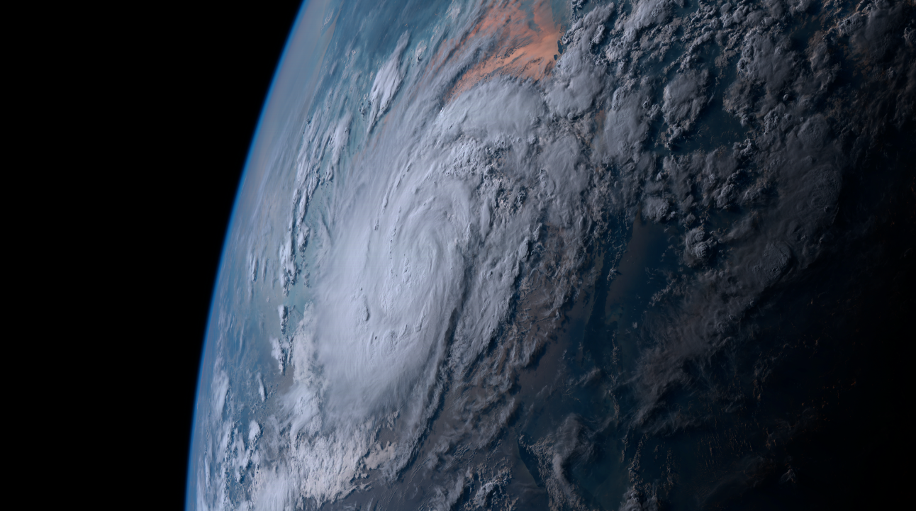
Cyclone Mocha formed this morning and could become one of the strongest cyclones to landfall in Myanmar, currently threatening millions of people living in the coastal areas of the country & Bangladesh.
Current Information
According to the Indian Meteorological Department’s (IMD) 5:30 pm IST (12:00 pm UTC) update, Mocha is located at 12.2°N, 88.0°E. This is around 520 km west of Port Blair & 1,020 km south-southwest of Sittwe in Myanmar. The cyclone has 3-minute sustained winds of 60 mph (90 kph) gusting up to 65 mph (105 kph) & a central pressure of 994 millibars. The system is currently moving northwards with a speed of 7 mph (11 kph).
Force Thirteen has analyzed the system with 1-minute sustained winds of 70 mph (110 kph) & a central pressure of 983 mb based on scatterometer data & satellite appearance of the cyclone.
Current Forecast
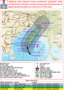
Mocha is expected to move northward till tomorrow, with gradual intensification into a Category 1-equivalent cyclone in the Saffir-Simpson scale and a Very Severe Cyclonic Storm on the IMD scale. Afterwards, it will turn northeast, rounding the periphery of the subtropical ridge over the Indo-China Peninsula, before making landfall in the border of Myanmar – Bangladesh near Sittwe (Akyab) as a high-end major cyclone on the morning of May 14th.
Risk Related to Cyclone
In the wake of the system, the RSMC has given warnings of:
- Wind – Hurricane force winds of 130-160 kph are expected as Mocha moves over the
landfall area on May 14th. Nearby Bangladesh coast could also experience gale force winds while northeast India may record winds of 50-60 kph gusting to 70 kph on the same day. - Sea Conditions – During the passage of the storm, surge height will be 3-4 meters in estuary & tributaries at districts like Sittwe and Maungdaw, whereas 2-3 meters of storm surge are expected at Rakhine & Kyaukpyu districts but the topographical features like creeks near Sittwe will be prone to the highest storm surge in the basin, with 15 meters.
- Rainfall – Widespread light to moderate rainfall with some isolated areas experiencing heavy to very heavy rainfall (65-205 mm) is expected over
Andaman & Nicobar Islands and isolated areas of northeast India. Light rainfall with cloudy sky conditions should also be expected over the coastal areas of Odisha & Gangetic West Bengal alongside Kolkata as the size of the storm gets larger. There’s also a chance that the cyclone could make heavy rainfall in the Yunnan province of China too during its weakening. Rainfall is expected to continue till May 14, with 80mm already occurred today at Car Nicobar due to the influence of the system.
Due to the prevailing hazardous conditions fishermen are
advised not to venture into sea & regulations of tourism & off
shore activities in Bay of Bengal till May 14.
Preparations

As the cyclone’s threat continues to grow, Bay of Bengal the Chief Minister of West Bengal Mamata Banarjee has asked the NDRF to remain well prepared & maintain sufficient stock of relief materials. The Bangladesh Red Crescent Society also did a evacuation drill in BashanChar today.
The region, specifically southeast Bangladesh & the Myanmar coast, didn’t witness any major cyclone for a long time, and due to the high population density the region is pretty much vulnerable. As so, Force Thirteen will bring you every update regarding it to you.

Cat 5
Crazy, usually doesn’t get this strong, but I’m not surprised. It’s always the Bay of Bengal that gets the strongest cyclones.