Guam starts recovery as Typhoon Mawar speeds away

The island of Guam looks to start its recovery as Typhoon Mawar speeds away from the island, regaining Category 5 strength with more intensification on the way.
Current information
As of 12:00 UTC (10pm local time), Mawar is located at 14.8 degrees north, 141.6 degrees east, or about 195 miles west-northwest of Guam. The Japan Meteorological Agency (JMA) has estimated Mawar to have 10-minute winds of 125 mph (200 kph), and a central pressure of 910 millibars, becoming the most intense typhoon of the season so far. The Joint Typhoon Warning Center (JTWC) has Mawar with 1-minute sustained winds of 170 mph (280 kph), equivalent to a very strong Category 5 storm on the Saffir-Simpson scale, and also the strongest typhoon of the year so far. The storm is currently moving west-northwest at 12 mph (19 kph).
Current warnings
All warnings have been lifted off by the National Weather Service’s Weather Forecast Office in Guam.
Current forecast
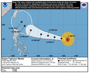
Mawar is expected to continue intensifying as it takes advantage of the highly favorable conditions, with warm sea surface temperatures, low wind shear, and strong radial outflow. The JTWC forecasts Mawar to peak with winds of 180 mph (290 kph) by tomorrow, as it continues west-northwest under the influence of a subtropical ridge to its north. By Sunday, its expected to turn towards Taiwan and slow down as it enters a competing steering environment between a subtropical ridge to its west, over southeast China, and another to its east. The storm is forecast to weaken by then due to increasing shear, weaker divergence aloft and possibly upwelling.
Model guidance remains consistent on its track for the next 3 days, before spreading out due to the aforementioned competion of steering environments. The ECWMF model in particular shows the storm stalling very close to Luzon before turning northwest once again. The HWRF model is much north of the JTWC forecast, as it expects Mawar to turn northwestwards towards the East China Sea. The GFS remains close to the forecast track.
Intensity-wise, models support a steady weakening trend in the next 3 days, before it drops Mawar significantly below major typhoon status by the end of the period.
Aftermath in Guam
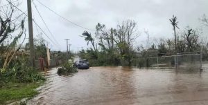
After Mawar exited the Marianas earlier today, the governor of Guam, Lou Leon Guerrero, declared the island is back to Condition of Readiness 4, according to her statement.
As a result, relevant agencies have started to work to return normal services to the island. According to KUAM News, the Guam Power Authority has begun the restoration of power access, with crews starting on the main transmission lines, while others work on individual circuits. Prioritized to bring back power are critical facilities such as hospitals, water wells, schools, public safety and ports of entry. The GPA has asked not to flood their dispatch with calls, as they are working as fast as they can to restore power.
The Guam Water Authority has also been working to restore access in the island, although no timetable has been given. A Boil Water notice has been issued for customer safety. GWA has asked the public with access to conserve water.
The AB Won Pat Guam International Airport remains closed. The Guam International Airport Authority completed initial damage inspections and terminal facilities, with airfield recovery efforts underway. Humanitarian and cargo flights are being allowed to enter. The terminal flooding is being prioritized to get the airport’s equipment back online. The airfield is being assessed and meetings are planned with airlines and other key stakeholders on their operational plans and the terminal’s status.
The National Weather Service’s WFO Guam earlier shut down its operations, as they were running on generators and are without air conditioning and water, and as such the NWS office in Honolulu, Hawaii took over warning the system for Guam.
According to NWS Guam’s Landon Aydlett, other staff of their office have gone to Hawaii to assist in shift changes as operations are turned over to allow local staff to take care of their family and residences.
Mawar looks to move near the Philippines and Taiwan, so residents there should monitor the storm’s progress. Stay tuned to us as well as we continue to cover the storm’s possible impacts.
