Intense Tropical Cyclone Freddy: A Looming Threat to Madagascar
Latest Information
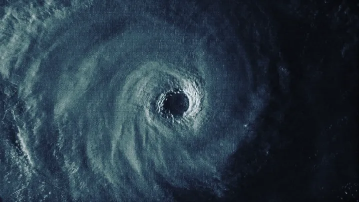
Intense Tropical Cyclone Freddy continues to roam across the Southern Indian Ocean and increasingly becoming a threat to Mauritius, La Reunion, and Madagascar. On the latest Force Thirteen analysis, the storm was last located at 15.8S 74.0E or about 1,180 kilometers (733 miles) west-northwest of Rodrigues, Mauritius. It is estimated that the storm is packing 1-minute sustained winds of 250 kph (135 knots / 155 mph,) with a minimum central pressure of 930 hPa and moving westward at a speed of 26 kph (16mph.)
Force Thirteen Discussion:
Freddy has redeveloped significantly during the daytime, with Central Dense Overcast (CDO) cooling as the spikes went at all quadrants. The current intensity estimate of Freddy is determined by subjective Dvorak 6.5 estimate (127kt) while going to the upper end of the range uncertainty due to extraordinary eye temperature and very symmetric CDO. AMSR2 at 0900z also retrieved 114-116kt (10min) winds, which is equivalent to 120-125kt with moderate uncertainty due to no available calibration algorithm/research. And since then the CDO is rapidly developing, with a resounding stadium effect and eye temperature warmed considerably to 20C, as shown in enhanced infrared satellite imagery. Unfortunately, other objective estimates are available as CIMSS estimates are not available again at this crucial moment until 1200z. As a result, it is also noted that the uncertainty of the estimate is higher than usual with only the Dvorak technique available.

Current Warnings
Green Cyclone Warning is raised over the regions of:
- Analanjirofo
- Atsinanana
- Fitovinany
- Vatovavy
- Atsimo-Atsinanana
Upgrade to yellow and red cyclone warnings are expected for the coastal regions in the coming days. More areas are expected to be under cyclone warnings as the storm approaches.
Ads by 
Cyclone Risks
Intense Tropical Cyclone Freddy is forecast to approach the island of Rodrigues on Sunday, 19 February, and then Mauritius and La Reunion on Monday, 20 February. The outer periphery of the storm is expected to bring gale-force winds, heavy rainfall, and dangerous swells.
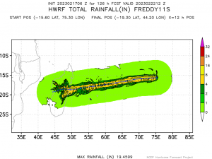
The cyclone is then expected to make landfall over Madagascar in the early hours of Wednesday, 22 February. The storm is still expected to be strong at the time of the landfall with significant wind and flood damage expected. The United Nations Office for the Coordination of Humanitarian Affairs notes that still tens of thousands of people are still homeless in the aftermath of Cyclone Cheneso making it difficult to the authorities to move them away from the storm’s path.
Local authorities in Mozambique, meanwhile, issued warnings on expected heavy rains for the Zambesi River as the cyclone is forecast to make landfall in Mozambique later next week.
If the local officials advised you to evacuate in preparation for the storm, please heed their advice. You can always check their social media sites for and follow developments from us on Facebook, Twitter, and YouTube as the storm approaches land.