Super Typhoon Mawar Now Approaching Guam
Typhoon Mawar has become a category 5 super typhoon by Force Thirteen’s analysis, and is posing a major threat to the entire island of Guam.
Current information
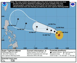
As of the 1am local time (3pm UTC) National Weather Service’s Guam Weather Forecast Office (WFO) update, Mawar is located at 12.3 degrees north, 145.9 degrees east, or about 110 miles southeast of Guam. The Japan Meteorological Agency (JMA) has estimated Mawar to have 10-minute winds of 115 mph (185 kph), and a central pressure of 930 millibars. Meanwhile, the Joint Typhoon Warning Center (JTWC) has Mawar with 1-minute sustained winds of 155 mph (250 kph), equivalent to a Category 4 super typhoon on the Saffir-Simpson scale. The storm is currently moving west-northwest at 5 mph (8 kph).
Force Thirteen currently has Mawar with winds of 160 mph (260 kph) and a pressure of 920 millibars as it is undergoing an eyewall replacement cycle. Earlier, the storm was estimated to have winds of 175 mph (280 kph) given its satellite presentation, with a 20 degrees Celsius eye seen on satellite imagery.
Current warnings
NWS Guam has issued the following warnings:
- Typhoon Warning, meaning typhoon-force winds are expected, for Guam and Rota;
- Tropical Storm Warning, meaning tropical storm-force winds are expected, for Tinian and Saipan; and
- Typhoon Watch, meaning typhoon-force winds are possible, for Tinian and Saipan.
Additionally, a Coastal Flood Warning and a Flood Watch is in effect for all aforementioned areas.
Current forecast

Mawar is forecast to continue its eyewall replacement cycle tonight local time before restrengthening. As it makes its west-northwest turn following the flow associated to a subtropical ridge to its north, the storm is forecast to strike tomorrow noon local time, with the JTWC forecasting Mawar to strengthen to a Category 5 typhoon officially before then. After Guam, the storm is expected to solidly follow the ridge before it approaches the ridge axis by Sunday.
Model track guidance appears to have built confidence on where the storm will go throughout the next 5 days, although the future remains uncertain on where the storm will go after those 5 days. Models also predict the storm to be a major typhoon throughout the period.
Ads by 
Current hazards

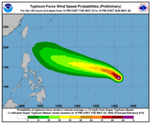
- Winds: The latest forecast is for typhoon force winds (winds 74 mph or greater) to move in Guam by tomorrow morning increasing through the morning to around a peak of 155 mph near the eye wall. Gusts could reach to around 170 mph or up to 190 mph near the eye wall. Exposed, higher terrain of the island is likely to experience higher winds. Wind direction at any point on Guam is highly dependent on the exact track of the eye. A direct passage over the island would lead to major typhoon force winds from a mix of directions. A passage just south of Guam would favor major typhoon force north to northeast winds shifting east and then southeast to south. A passage just north of Guam would favor major typhoon force winds from the northeast to west, then southwest to west. Typhoon force winds will extend outward from the center roughly 30 miles.
For Rota, tropical storm conditions will arrive later tonight, with typhoon conditions a distinct possibility around noon Wednesday if Mawar remains a bit farther north than the current forecast track.
In Tinian and Saipan, east to northeast winds will increase tonight, becoming damaging tomorrow morning in the 30 to 40 mph with gusts to 55 mph or so. Higher winds are likely for higher terrain such as Capitol Hill. Winds are forecast to increase further Wednesday afternoon as they shift to an easterly then southeasterly direction. Typhoon conditions are still possible for Wednesday afternoon, but this hinges on a northward drift with Mawar.
- Rainfall: Heavy rainfall is likely to develop in Guam tonight through the next few days. Torrential rain is likely as Mawar passes near or overhead. Rainfall amounts of 10 to 15 inches are possible with locally higher amounts of 20 inches or more. Landslides are a distinct possibility for central to southern Guam along with overflowing streams and rivers.
In Rota, torrential rain is quite possible as Mawar passes to the south closer to Guam. Rainfall amounts of 4 to 8 inches are possible with locally higher amounts. A slowing of forward speed and drift farther north could lead to higher rainfall totals.
In Tinian and Saipan, heavy rainfall is possible tonight through tomorrow night with rainfall amounts of 2 to 5 inches. If Mawar shifts a bit farther north, rainfall amounts could rise to between 5 and 8 inches.
- Storm surge: Storm surge of 6 to 10 feet above the normal high tide is expected as Mawar moves overhead Guam on Wednesday. Surge may reach to between 20 and 25 feet above normal high tide for the most vulnerable storm surge prone areas near the eye wall, just north of Mawar’s eye. Mawar’s angle of approach could lead to considerable coastal impacts and surge for Malesso, Inalahan, Ipan and Pago Bay, especially if the center of Mawar scrapes by just south of Guam. Coastal roads of Guam around Inalahan and Malesso may be impassable due to lofted beach debris and boulders if this southern track is realized. Surge of 1 to 3 feet is possible within Apra Harbor. Surge may reach 4 feet along western shores when Mawar passes over Guam.
In Rota, storm surge of 2 to 5 feet above the normal high tide is expected as Mawar passes closer to Guam on Wednesday. Higher surge values around 5 feet would be realized if Mawar passes closer to northern Guam.
In Tinian and Saipan, storm surge of 1 to 3 ft above the normal high tide is expected along the south and eastern shores.
Mawar is likely to bring considerable damage to buildings and homes of light material, and extensive damage to non-concrete roofs in Guam. Non-reinforced concrete walls could be blown down. Severe damage to well-built wooden and metal structures possible. Some reinforced hollow-spun concrete power poles and many reinforced wooden power poles could be downed. Solar panels could be damaged. Large projectiles and debris are possible. Most small and medium sized steel frame signs could be bent over or damaged. Some fuel storage tanks could rupture. Cars and high paneled vehicles could be overturned. Major damage to shrubbery and trees is likely with snapped or uprooted trees and blocked roads. Defoliation of vegetation is likely, perhaps 50-70% defoliation.
Electricity and water may be unavailable for days and perhaps weeks after the storm passes. Most trees will be snapped or uprooted. Fallen trees may cut off residential areas for days to weeks.
The storm is closing in on Guam, so preparations must be completed by now. If you do not feel safe at your home, evacuate to the nearest evacuation center as soon as possible. During the storm, stay inside and away from windows. Do not venture outside when high winds are occurring or during temporary lulls as flying debris can easily, and suddenly, cause serious injury. If the eye passes over you, extreme winds will suddenly cease. This is not the end of the typhoon – REMAIN IN SHELTER as extreme winds will rapidly resume. Stay tuned to your local officials and to us as the storm progresses.
