Super Typhoon Ragasa (Nando) Barrels Towards the Babuyan Claro Island, Forcasted to Aim For China and Vietnam
 Barrels Towards the Babuyan Claro Island, Forcasted to Aim For China and VietnamSeptember 22nd, 2025 at 00:40 AM • 9 months ago| 1")
Super Typhoon Ragasa (PAGASA: Nando) is currently targeting one of the Babuyan Islands north of the Philippines today at 7:00 a.m. PHT.
The Joint Typhoon Warning Center is closely monitoring Ragasa’s path as it is expected to make landfall in one of the Babuyan Islands, while also issuing critical warnings for the coastlines of China and Vietnam.
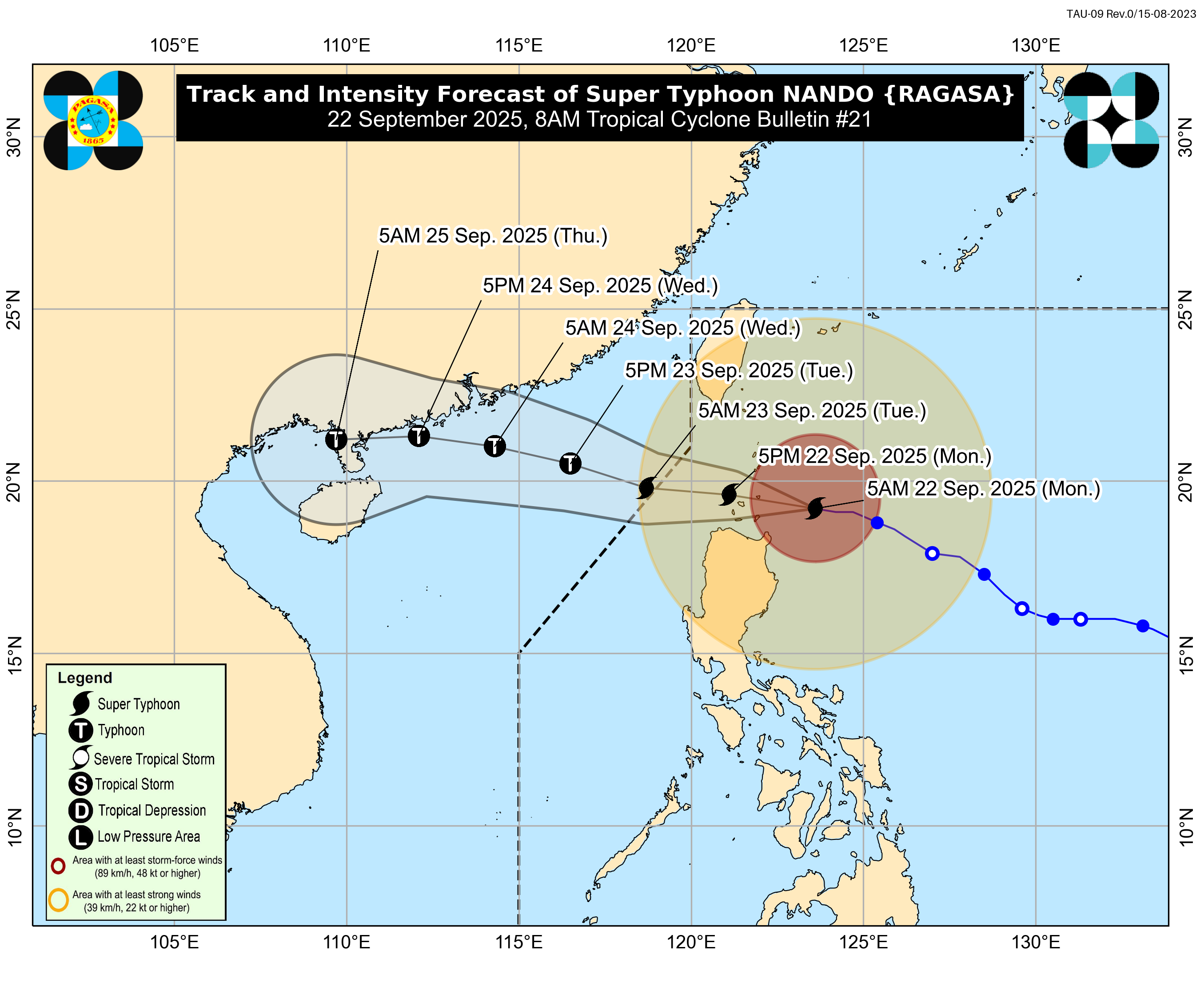
(Credit: PAGASA)
Current Information
As of 20Z today, Ragasa was located at 245 km East of Calayan, Philippines, and was moving west-northwestward at 20 km/h.
The latest outlook from the Philippines’ TCB states supported maximum winds of 250 km/h and a central pressure of 915 hPa.
Current Warnings and Watches
A TCWS Warning No. 5 is in effect for the northern portions of the Babuyan Islands, while the rest of the Babuyan Islands, the north portion of the Cagayan mainland, and the southeastern portion of the Batanes are under a TCWS No. 4.
Meanwhile, there may be potential warnings for the coastal areas of China and Vietnam in the next update.
If you live in the affected portions stated above, it is highly recommended to monitor additional warnings or watches issued by your local weather service within your area.
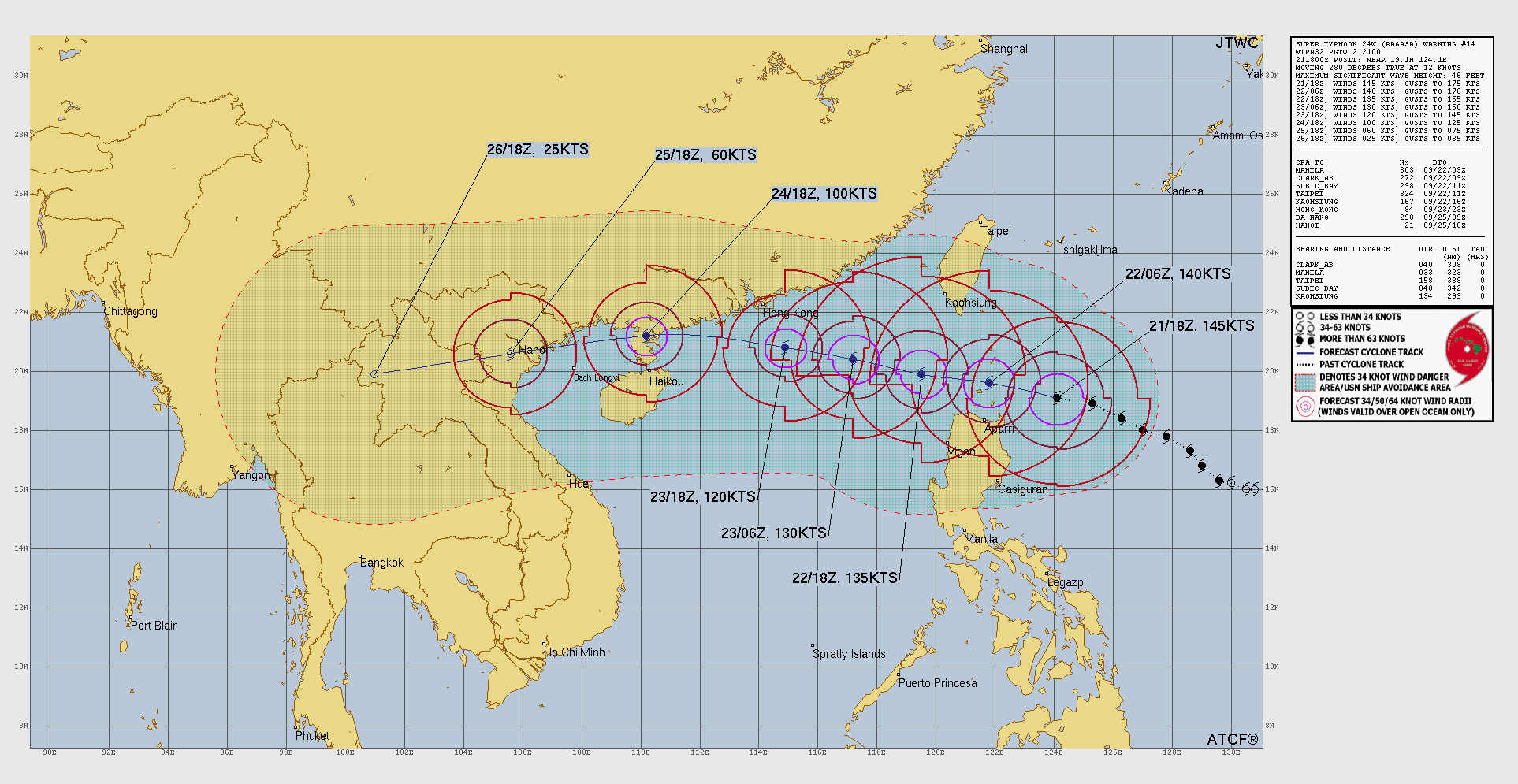
(Credit: JTWC)
Current Forecast
According to the cone forecast issued by the JTWC as of 21Z, Ragasa will cross the Luzon Strait while expected to make landfall in the Babuyan Islands.
By 18Z on Wednesday, Ragasa will strike the Zhanjiang peninsula and then dissipate after reaching the Vietnamese coast by this Friday.

(Credit: Force Thirteen/JMA/Himawari-9)
Ads by 
Current Hazards
From the latest bulletin issued by the Philippines’ Tropical Cyclone Board, winds generated by Super Typhoon Ragasa may be slightly stronger in coastal and upland/mountainous areas, which will cause significant damage to the affected areas of the Babuyan Islands, the Batanes, and the northern portions of the Cagayan mainland.
Additionally, heavy rainfall will also be expected from this typhoon, as more than 200 mm of rain will cause widespread incidents of severe flooding and landslides in the affected portions.
Lastly, the southwest monsoon and the trough of Ragasa will bring gusts to the Luzon areas today and tomorrow.
If possible, evacuate when directed by officials, and stay tuned to your local weather service or Force Thirteen for updates.
😯