Typhoon Doksuri approaching the Philippines
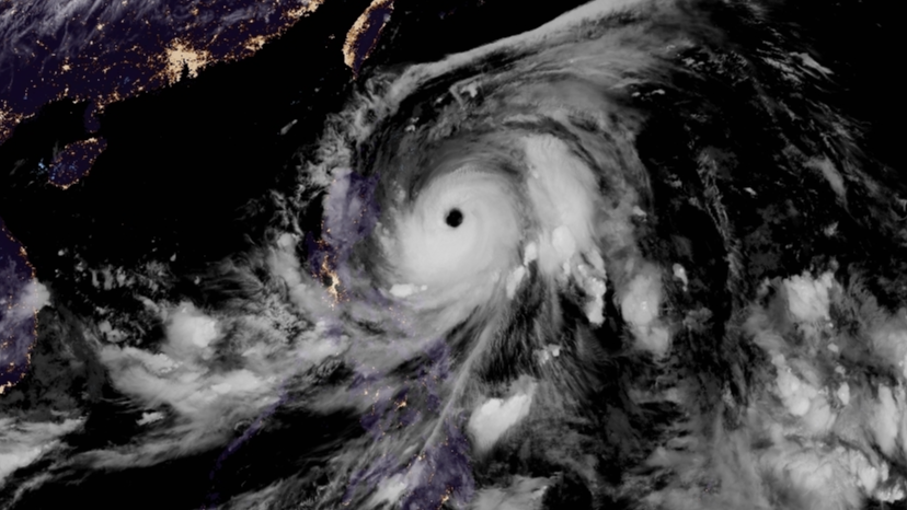
Typhoon Doksuri (Philippine name Egay) has continued its rapid intensification throughout today, becoming a Category 4 typhoon as it moves closer to the Philippines.
Current information
As of 8:00 pm PHT (12:00 UTC), Doksuri is currently located at 16.5 degrees north, 125.8 degrees east, or about 365 km east of Casiguran, Aurora. The Japan Meteorological Agency has Doksuri with 10-minute sustained winds of 170 km/h (100 mph), gusts up to 240 km/h (150 mph), and a central pressure of 940 millibars. The Joint Typhoon Warning Center has estimated the storm with 1-minute sustained winds of 220 km/h (140 mph), making it a Category 4-equivalent typhoon on the Saffir-Simpson scale. The storm is currently moving north-northwest at 17 km/h (10 mph).
Force Thirteen currently estimates Doksuri with 1-minute sustained winds of 230 km/h (145 mph), which is slightly higher than the JTWC’s estimate, and a central pressure of 934 millibars.
Current warnings

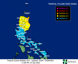
The Philippine Atmospheric, Geophysical and Astronomical Services Administration (PAGASA) has issued the following wind signals as Doksuri nears the country:
- Signal 3 warnings for Santa Ana, Gonzaga, Peñablanca, Baggao, Gattaran, and Lal-lo, Cagayan; Divilacan and Maconacon, Isabela;
- Signal 2 warnings for Batanes, Babuyan Islands, the rest of mainland Cagayan, the rest of Isabela, Quirino, the northern portion of Nueva Vizcaya (Kasibu, Quezon, Diadi, Bagabag, Ambaguio, Villaverde, Solano, Bayombong), Apayao, Kalinga, Abra, Mountain Province, Ifugao, the northern portion of Benguet (Bakun, Mankayan, Buguias, Kabayan, Kibungan), Ilocos Norte, Ilocos Sur, and the northern and central portion of Aurora (Dilasag, Casiguran, Dinalungan, Dipaculao);
- Signal 1 warnings for the rest of mainland Luzon, central and eastern portions of Romblon (Banton, Corcuera, Romblon, Magdiwang, Cajidiocan, San Fernando), Northern Samar, the northern and central portions of Samar (Almagro, Tagapul-An, Santo Niño, Daram, Zumarraga, Villareal, Talalora, Hinabangan, Calbiga, Pinabacdao, Paranas, Motiong, San Sebastian, Jiabong, City of Catbalogan, San Jose de Buan, Matuguinao, San Jorge, Tarangnan, Gandara, Pagsanghan, Santa Margarita, Calbayog City), the northern and central portions of Eastern Samar (City of Borongan, San Julian, Sulat, Taft, Can-Avid, Oras, Arteche, Jipapad, Dolores, San Policarpo, Maslog), and Biliran.
PAGASA has also issued storm surge warnings for Batanes, Isabela, Cagayan, Ilocos Norte and the extreme northern portion of Ilocos Sur (Cabugao, Magsingal, San Juan (Lapog), Simait) which can expect 2.1 – 3.0 meters of storm surge. The coasts of Maconacon, Isabela and Peñablanca, Cagayan are expected to get more than 3 meters of storm surge.
Current forecast

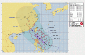
Doksuri is entering an eyewall replacement cycle, as evidenced by a microwave pass showing dry air over the southeastern quadrant of the system. The current JTWC forecast has the storm passing near the tip of Cagayan and traverse the Luzon Strait, which the Babuyan Group of Islands and Batanes are located, on Tuesday into Wednesday local time. The exact intensity of the system is uncertain as it will undergo the aforementioned cycle, but will likely remain a major typhoon as it passes through the islands.
As it continues northwestwards under the influence of a deep-layered subtropical ridge over Japan, it’s expected to encounter unfavorable conditions with decreasing sea surface temperatures and land friction, and make landfall near Xiamen, China as a high-end Category 1 typhoon by Thursday. The system is expected to weaken significantly as it turns north and dissipate by Saturday.
Current hazards
- Rain: Doksuri is forecast to drop above 200 millimeters of rainfall as it moves near Batanes, Babuyan Islands, the northeastern portion of mainland Cagayan, Ilocos Norte, Ilocos Sur, Apayao, and Abra on Tuesday night into Wednesday. Under these conditions, flooding and rain-induced landslides are highly likely especially in areas that are highly or very highly susceptible to these hazards and in localities that experienced considerable amounts of rainfall for the past several days. The southwest monsoon, currently being enhanced by the system, will continue to bring occasional to monsoon rains over the western portions of Central Luzon, Southern Luzon, and Visayas in the next three days.
- Wind: Moderate to significant impacts from storm-force winds may be experienced within the areas under Wind Signal No. 3. Minor to moderate impacts from gale-force winds are possible within any of the areas where Wind Signal No. 2 are in effect, and minimal to minor impacts from strong winds are also possible within any of the areas where Wind Signal No.1 is hoisted. The current PAGASA forecast shows that the highest wind signal that may be hoisted will be Wind Signal No. 4 or 5 (e.g., typhoon-force wind threat). Doksuri and the enhanced southwest monsoon will continue to bring gusty conditions over Luzon, Visayas and portions of Mindanao over the next 3 days.
- Storm surge: There is a high risk of storm surge which may cause flooding in the low-lying and exposed coastal areas of of Batanes, Cagayan, Isabela, Ilocos Norte, and the extreme northern portion of Ilocos Sur. Maximum surge heights may reach 2.0 m in most of the warning areas, with some localities exceeding 2.0 m surge heights.
Doksuri is continuing to approach the country, and as such, preparations should be nearing completion. Homes should be reinforced, and supplies must be replenished. Evacuate if the local officials have said to do so, and stay updated with your local PRSD. Stay tuned to us as well as we continue to cover the system’s progress.

