Typhoon Doksuri reintensifies as it barrels towards China
Typhoon Doksuri has reintensified significantly, and is now a Category 3 typhoon as it leaves the Philippines and approaching the coast of southern China.
Current information
As of 8:00 pm CST (12:00 UTC), Doksuri is located at 21.8 degrees north, 119.1 degrees east, or about 360 km southeast of Xiamen, Fujian. The Japan Meteorological Agency has Doksuri with 10-minute sustained winds of 150 km/h (90 mph), with gusts of 210 km/h (130 mph), and a central pressure of 955 millibars. The Joint Typhoon Warning Center estimated Doksuri to have 1-minute sustained winds of 195 km/h (120 mph), which is equivalent to a Category 3 system on the SSHWS. The storm is moving north-northwest at 13 km/h (8 mph).
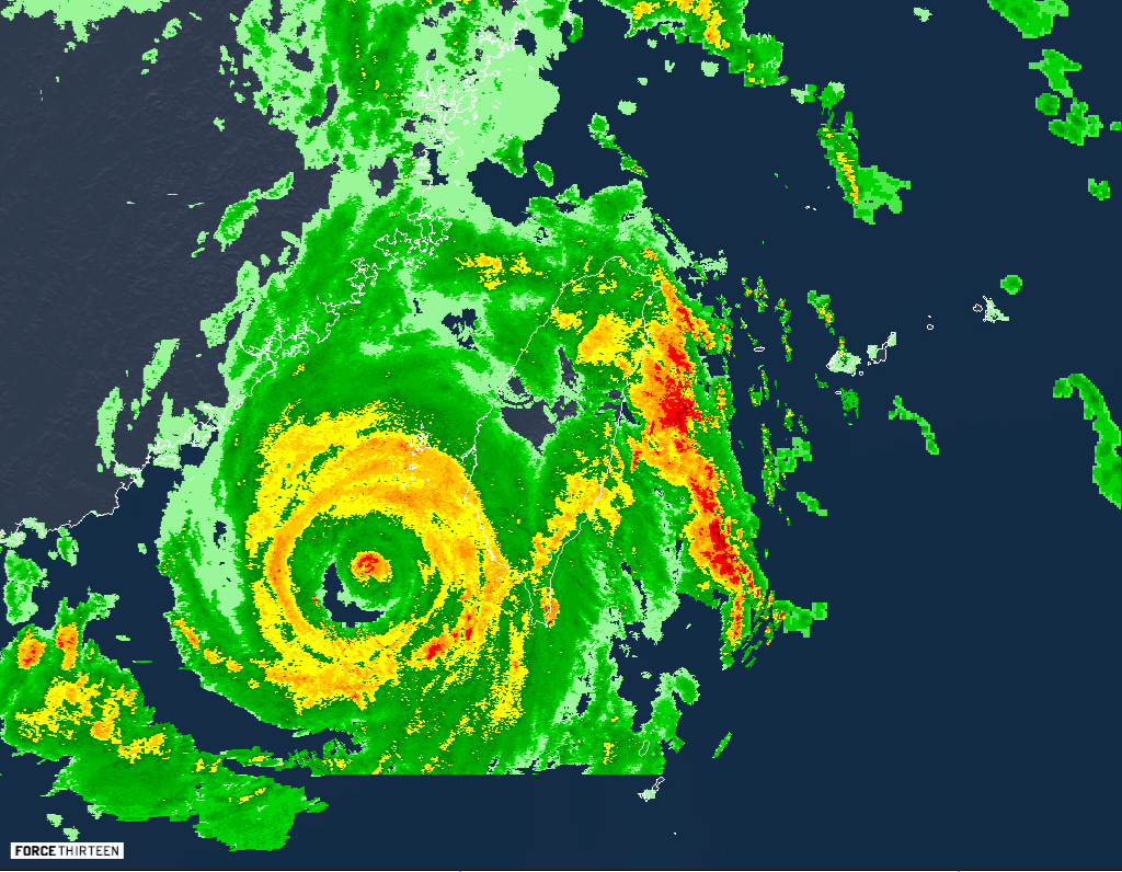
Force Thirteen currently has Doksuri with 1-minute sustained winds of 200 km/h (125 mph), which is slightly higher than the JTWC estimate, and a central pressure of 939 millibars. The wind estimate is supported by the range of satellite estimates and radar velocity (>60m/s at 3km) reported from Taiwan and Xiamen radars.
Current warnings
The China Meteorological Administration has issued the following warnings:
- Red Typhoon Warning for Zhangzhou & Xiamen, Fujian;
- Orange Typhoon Warning for Jieyang & Chaozhou, Guangdong, and Quanzhou, Fujian;
- Yellow Typhoon Warning for Wenzhou & Ningde, Fujian, and Fuzhou, Zhejiang; and
- Blue Typhoon Warning for Quzhou, Zhejiang, Sanming, Fujian, Pudong New District, Shanghai, and the entirety of Jiangxi.
The Hong Kong Observatory and the Macau Meteorological and Geophysical Bureau have hoisted their Standby Signal No. 1 for their respective regions, with higher signals unlikely to be raised.
The Central Weather Bureau in Taiwan has issued typhoon warnings in Nantou, Chiayi, Pingtung, Changhua, Penghu, Taitung, Hualien, Miaoli, Kinmen, & Yunli counties, and in Chiayi, Tainan and Kaoshiung City.
Current forecast
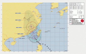
Although abysmal on radar imagery, with a 6 nautical mile pinhole eye embedded within a moat of clear air and a secondary eyewall, the system is under a favorable environment of 31 degrees Celsius sea surface temperatures, and even more warmer towards the coast of China due to coastal downwelling induced by the system, along with low wind shear, robust poleward and strong equatorward outflow. It will continue its reintensification before it strikes Xiamen in the next 12–18 hours, with the current JTWC forecast calling for a Category 4 system to hit the area, although a slightly stronger system cannot be ruled out if the eyewall replacement cycle currently ongoing on the system can fully complete. After it hits land, it is expected to weaken quickly, and dissipate by Saturday.
Current hazards
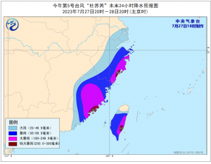
- Rain: Doksuri will continue to drop heavy rainfall across China, Taiwan and the Philippines, with 250–300mm of rainfall forecast to drop in southeastern portions of Fujian, Zhejiang, and Taiwan. In the Philippines, the southwest monsoon enhanced by Doksuri will continue to bring occasional to monsoonal rains over the western portion of Luzon in the next three days.
- Wind: In parts of southern Fujian and the coast, winds may reach hurricane-force as Doksuri approaches, with the rest of Fujian, Zhejiang and the eastern part of Guangdong experiencing storm-force winds.
Current situation in the Philippines

(Credits: Marikina City Rescue 161/FB)
Doksuri, known in the Philippines as Egay, has continued to drop large amounts of rainfall in northern Luzon. The weather station in Baguio has recorded 265mm of rainfall over the past 24 hours, followed by Sinait, Ilocos Sur with 245mm, and Laoag, Ilocos Norte with 150mm. These amounts were likely exacerbated by the mountainous terrain in the area. 6 people were reported dead, 11 were injured, and more than 400,000 affected, according to the National Disaster Risk Reduction and Management Council.
Down south, the southwest monsoon enhanced by the storm has also dropped a significant amount of rain, with a weather station in Subic Bay recording 164mm of rainfall. The capital, Manila, has experienced 47mm of rainfall over the past 24 hours. The continuous rainfall led to the Marikina River hitting its second alarm of 16 meters, but has now decreased below alarm levels.
The system continues to be a threat to land, and so preparations in China must be nearing completion. Keep updated with your local officials and to us as the system progresses.
