Typhoon Doksuri slows down, dumping heavy rainfall in Philippines
Typhoon Doksuri (Egay) has weakened down into a Category 2 typhoon as it slows down near Luzon, dumping heavy rainfall and causing flooding on many areas in the region.
Current information
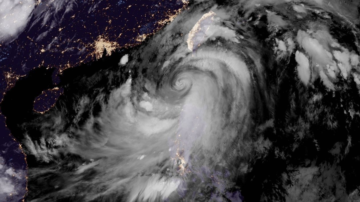
As of 11:00 pm PHT (15:00 UTC), Doksuri is located at 19.5 degrees north, 120.6 degrees east, or about 120 km west-northwest of Calayan, Cagayan. The Japan Meteorological Agency has estimated Doksuri to have 10-minute winds of 160 km/h (100 mph), with gusts of 220 km/h (140 mph), and a central pressure of 950 millibars. The Joint Typhoon Warning Center has Doksuri with 1-minute sustained winds of 175 km/h (110 mph), making the storm a Category 2 on the Saffir-Simpson scale. It is currently moving northwestward at 9 km/h (6 mph).
Force Thirteen has estimated the storm to have winds of 160 km/h (100 mph), which is lower than the current JTWC estimate, and a central pressure of 954 millibars.
Current warnings
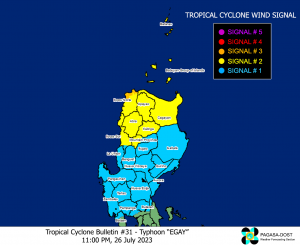
The PAGASA has currently hoisted the following Tropical Cyclone Wind Signals (TCWS):
- TCWS #3 for the northwestern portion of Ilocos Norte (Bangui, Pagudpud, Burgos, Pasuquin);
- TCWS #2 for Cagayan including Babuyan Islands, Kalinga, Abra, the rest of Ilocos Norte, Apayao, the northern and central portion of Ilocos Sur (Gregorio del Pilar, Magsingal, San Esteban, Banayoyo, Burgos, City of Candon, Santa Lucia, Santiago, San Vicente, Santa Catalina, Lidlidda, Nagbukel, Sinait, Suyo, Sigay, San Ildefonso, Galimuyod, Quirino, City of Vigan, San Emilio, Cabugao, Caoayan, San Juan, Santa, Bantay, Santo Domingo, Santa Cruz, Santa Maria, Narvacan, Salcedo, Tagudin, Cervantes), the western portion of Mountain Province (Besao, Sagada, Bontoc, Sadanga, Tadian, Sabangan, Bauko), and Batanes; and
- TCWS #1 for Isabela, the rest of Mountain Province, Ifugao, Zambales, Pangasinan, Benguet, La Union, Nueva Vizcaya, the rest of Ilocos Sur, Quirino, Aurora, Nueva Ecija, Tarlac, Pampanga, the northern portion of Bataan (Morong, Samal, Orani, Hermosa, Dinalupihan) and the northern portion of Bulacan (Hagonoy, Doña Remedios Trinidad, Paombong, City of Malolos, Plaridel, Guiguinto, Pandi, Bustos, Angat, Calumpit, Pulilan, Baliuag, San Rafael, San Ildefonso, San Miguel).
The Central Weather Bureau of Taiwan has issued typhoon warnings for Nantou, Chiayi, Pingtung, Changhua, Penghu, Taitung, Hualien and Yunlin counties, along with Chiayi, Tainan and Kaoshiung City.
The China Meteorological Administration has issued the following warnings:
- Orange Typhoon Warning for Shantou, Guangdong;
- Yellow Typhoon Warning for Zhangzhou, Xiamen, Quanzhou, Fuzhou and Ningde, Fujian, and Jieyang City, Guangdong; and
- Blue Typhoon Warning for Shanwei and Meizhou, Guangdong, and Wenzhou, Zheijang.
Current forecast
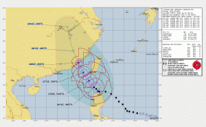
As a microwave pass showed, Doksuri’s eye is now weak and eroding, but as it moves away from Luzon, there is a small window of reintensification with an overall favorable environment, along with high oceanic heat content. The current JTWC forecast has the storm reintensifying into major typhoon status, before it interacts with the geography of Taiwan. As it moves north-northwestward, the storm will likely hit southern China as a weak typhoon by Friday, before dissipating shortly after.
Ads by 
Current hazards
- Rain: Doksuri is forecast to continue dropping 100-200mm of rainfall on Ilocos Norte, the northern portions of Ilocos Sur and Abra. Forecast rainfall are generally higher in elevated or mountainous areas. Under these conditions, flooding and rain-induced landslides are highly likely especially in areas that are highly or very highly susceptible to these hazards and in localities that experienced considerable amounts of rainfall for the past several days. The Southwest Monsoon enhanced by the storm will continue to bring occasional to monsoon rains over the western portions of Central Luzon and Southern Luzon in the next three days. Numerous rainfall warnings are also currently in effect in Taiwan.
- Wind: Moderate to significant impacts from storm-force winds may be experienced within the areas under Wind Signal No. 3. Minor to moderate impacts from gale-force winds are possible within any of the areas where Wind Signal No. 2 is in effect, and minimal to minor impacts from strong winds are also possible within any of the areas where Wind Signal No.1 is hoisted. The enhanced Southwest Monsoon will continue to bring gusty conditions over Luzon and parts of Visayas over the next 3 days.
- Storm surge: There is a moderate to high risk of storm surge which may cause flooding in the low-lying and exposed coastal areas of Batanes, Cagayan including Babuyan Islands, Ilocos Norte, and extreme northern portion of Ilocos Sur. Maximum surge heights may reach 3.0 m in most of the warning areas.
Current situation
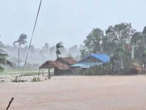
(Credits: Cagayan PIO)
Doksuri has already dropped more than 200mm of rainfall on some areas in northern Luzon. An automated weather station (AWS) in Baguio has already recorded 485mm of rainfall over the past 24 hours, followed by Laoag, Ilocos Norte with 410mm, and Sinait, Ilocos Sur with 397mm. These amounts were likely exacerbated by the mountainous terrains around the area. The AWS in Itbayat, Batanes has seen lesser rainfall, with 115mm recorded, along with Tuguegarao with 101mm.
According local media, 6 deaths have been reported in parts of Benguet, Mountain Province and Baguio. The National Disaster Risk Reduction and Management Council (NDRRMC) are still verifying the information, and also reported 2 were injured, with more than 180,000 people affected by the storm.
The storm continues to drop heavy rainfall, and we hope you are safe from this storm. Stay tuned to us and your local officials as the storm progresses.