Typhoon Mawar a Significant Threat to the Marianas
Tropical Storm Mawar has rapidly strengthened into a typhoon as it heads into the Marianas, where typhoon watches are in place.
Current information
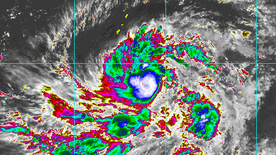
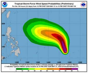
As of 12pm UTC (11pm ChST), Mawar is located near 7.7 degrees north, 147.9 degrees east, or about 95 miles east-northeast of Satawal, Yap, and about 440 miles south-southeast of Guam. The Japan Meteorological Agency has Mawar at 10-minute sustained winds of 70 mph (110 kph), and a central pressure of 985 millibars. The Joint Typhoon Warning Center has Mawar with 1-minute sustained winds of 80 mph (130 kph), making the storm a Category 1-equivalent typhoon in the Saffir-Simpson scale. The storm is currently moving northwest at 7 mph (11 kph).
Current warnings
The National Weather Office’s Weather Forecast Office in Guam has issued the following:
- Tropical Storm Warning for Ulul and Polowat, Chuuk, and Satawal, Yap;
- Typhoon Watch for Guam, Rota, Tinian and Saipan.
In addition, a Flash Flood Watch is also in effect in Guam. The governor of Guam has placed the Northern Mariana Islands in Tropical Cyclone Condition of Readiness (TCCOR) 3, while Guam is under a TCCOR 2.
Current forecast
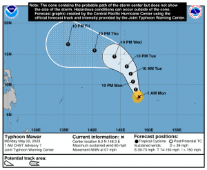
Mawar is expected to continue intensifying under a very favorable environment of warm sea surface temperatures and strong poleward and westward outflow limiting the effects of moderate wind shear. By Tuesday, Mawar is expected to pass very close to Guam and Rota near major typhoon status, before turning northwest. While the near-equatorial ridge moving northeast of it keeps the storm moving west-northwestward after moving across the Marianas, it’ll enter the waters of the Phillippine Sea with deep oceanic heat content, making a further intensification to super typhoon in the realms of possibility. The JTWC forecast currently calls for a 130 mph (210 kph) Category 4-equivalent typhoon for its peak intensity by Friday, while the JMA forecasts a peak intensity of 115 mph (185 kph).
Model guidance discrepancy has been increasing in days 4-5 intensity-wise, with the HWRF and CTCX models calling for a Category 5 typhoon by Friday, while the GFS are around what the JTWC is currently forecasting.
Mawar remains unpredictable in the next 5 days, but one thing is clear: the storm is nearing Guam, Tinian and other areas. Preparations should be completed soon, along with stocking of supplies. Keep updated with your local National Weather Service office, and stay tuned to us as the storm progresses.

It really has a shot at hitting the Philippines in the long run, right?
Mawar still has a big uncertainity with the tracks, but Guam and the Marina Islands are in life-threatening danger.