Typhoon Mawar continues to intensify, nearing Guam
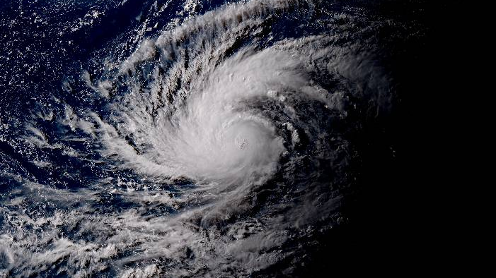
Typhoon Mawar has steadily strengthened over the past day and is nearing major typhoon status as it heads towards Guam, where typhoon warnings remain in place.
Current information
As of 12:00 UTC (10pm ChST), Mawar is currently located at 10 degrees north, 146.9 degrees east, or about 275 miles south-southeast of Guam. The Japan Meteorological Agency (JMA) has estimated Mawar to have 10-minute winds of 85 mph (140 kph) and a central pressure of 985 millibars. The Joint Typhoon Warning Center (JTWC) has Mawar with 1-minute sustained winds of 105 mph (165 kph), making the storm a Category 2-equivalent typhoon on the Saffir-Simpson scale. The storm is currently moving north-northwest at 8 mph (13 kph).
Current warnings
The National Weather Service’s Weather Forecast Office in Guam has issued the following:
- Typhoon Warning for Guam and Rota;
- Typhoon Watch for Tinian and Saipan; and
- Tropical Storm Warning for Tinian and Saipan.
In addition, a Flood Watch is in effect for all aforementioned areas.
Current forecast
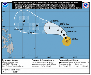
Mawar is forecast to continue intensifying under a favorable environment of warm sea surface temperatures, lowering wind shear, and strong poleward outflow. By Wednesday, the storm is expected to pass very close near Guam at major typhoon status as it turns west-northwestward, with the near-equatorial ridge to its east shifting poleward. Once passed Guam, Mawar will head to the Philippine Sea and will likely intensify into a strong Category 4-equivalent typhoon with the sea’s deep ocean heat content.
Force Thirteen is currently forecasting a Category 4 system to pass very near, or even slam Guam, barring any setbacks. Afterwards, the storm strengthens to a very strong Category 5 super typhoon in the Philippine Sea by Saturday, as it continues west-northwestward.
Ads by 
Current hazards

- Winds: The most likely onset of tropical storm conditions in Guam, Rota, Tinian and Saipan is tomorrow evening. In Guam and Rota, winds will steadily increase on Tuesday with damaging winds by Tuesday evening and destructive winds overnight. The latest forecast is for typhoon force winds to move in over on Wednesday with sustained winds of 120 miles per hour and gusts to 140 miles per hour. Wind direction for any given location is highly dependent on where the center tracks. With forecasts showing Mawar tracking near or over Guam, winds may very well be variable while Rota is most likely to see a wind direction from the northeast shifting east and then southeast. If the center moves through just south of Guam, a similar shift in the wind direction is likely for Guam.
- Storm surge: Storm surge of 4 to 6 feet above the normal high tide is expected as Mawar moves overhead on Wednesday. Surge may reach up to 8 feet just north of the center of the system. Surge may reach 2 to 4 feet along western shores. In Tinian and Saipan, storm surge of 1 to 3 ft above the normal high tide is expected as Mawar passes to the south, mainly along south and eastern shores.
- Rainfall: Heavy rainfall is likely to develop in Guam and Rota late tonight through the next few days. Torrential rain is likely as Mawar passes near or overhead. Rainfall amounts of 8 to 15 inches are possible with locally higher amounts. A slowing of forward speed could lead to much higher rainfall totals. In Saipan and Tinian, heavy rainfall is possible tomorrow night into Wednesday with rainfall amounts of 3 to 5 inches through Thursday. If Mawar shifts a bit farther north, rainfall amounts could rise considerably to between 6 and 10 inches.
As Mawar nears the Marianas, preparations should be nearing completion. Stock up supplies, cover your windows with shutters, and evacuate if needed. Residents in other countries such as the Philippines and Taiwan may need to watch the system as it moves over the Philippine Sea. Stay tuned to your local weather office and to us as the storm progresses.