Typhoon Mawar moving away from Guam
Typhoon Mawar grazed Guam earlier as a Category 4 typhoon, and is looking to reintensify as it moves away from the island on its way to the Philippine Sea.
Current information
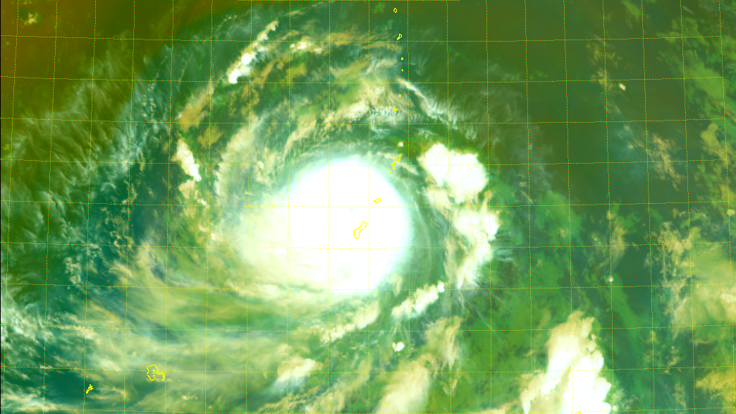
As of 12:00 UTC (10pm local time), Mawar is currently located near 13.7 degrees north, 144.6 degrees east, or about 20 miles to the northwest of Guam. The Japan Meteorological Agency (JMA) has estimated Mawar to have 10-minute winds of 110 mph (175 kph) and a central pressure of 940 millibars. The Joint Typhoon Warning Center (JTWC) has Mawar with 1-minute sustained winds of 140 mph (220 kph), equivalent to a Category 4 system on the Saffir-Simpson scale. The storm is currently moving northwest at 8 mph (13 kph).
Force Thirteen has estimated Mawar to have winds of 130 mph (210 kph), slightly lower than the JTWC estimate, with a central pressure of 942 millibars. The pressure estimate is supported by observations being transmitted in Guam currently.
Current warnings
The National Weather Service’s Weather Forecast Office in Guam has issued the following warnings:
- Typhoon Warning, meaning typhoon-force winds are expected, for Guam and Rota;
- Tropical Storm Warning, meaning tropical storm-force winds are expected, for Tinian and Saipan; and
- Typhoon Watch, meaning typhoon-force winds are possible, for Tinian and Saipan.
In addition, the NWS has issued a Coastal Flood Warning for all aforementioned areas, and a Flood Watch to Guam and Rota. It has also issued a Flash Flood Warning for Guam, due to the automated rain gauges showing rainfall in excess of 1 to 2 inches over the last hour, with several inches of rain already fallen. The expected rainfall rate is 1 to 2 inches per hour with locally heavier rainfall rates. Additional rainfall amounts of 8 to 10 inches are possible, with locally 15+ inches possible.
Current forecast
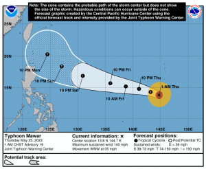
With Guam nearly out of the woods, Mawar looks to intensify once again as it completed its eyewall replacement cycle before passing very close to Guam earlier noon local time. The current JTWC forecast has the storm continue west-northwestward under the influence of a subtropical ridge to the north and the east throughout the 5 days. In those 5 days, the storm is expected to intensify into a Category 5 typhoon, fueled by warm sea surface temperatures, low vertical shear, and favorable upper-level outflow. By Sunday, the storm is expected to weaken as it passes over somewhat cooler sea temperatures.
Model guidance has remained fairly consistent with its track, although the GFS and the HWRF has the storm more north than the current JTWC forecast. Intensity-wise, models remain unified on a major typhoon over the next 5 days.
Ads by 
Current hazards
- Winds: Mawar’s intense southern eyewall winds have pivoted onshore Guam. Sustained winds of 140 mph, particularly along the southern eyewall, may persist over the island this evening and possibly through midnight. Winds will ease early Thursday morning, with damaging tropical storm conditions for much of the day on Thursday. Exposed, higher terrain of the island is likely to experience higher winds. For Rota, strong tropical storm force conditions may brush to typhoon force levels tonight. In Tinian and Saipan, east winds of 40 to 55 mph are expected late this evening and overnight, with higher winds and gusts expected for elevated terrain such as Capitol Hill. Typhoon conditions are not expected, however, outer rainbands may bring typhoon force gusts (60-70 mph) at times.
- Rainfall: In Guam, additional rainfall of 10 to 15 inches of rain is possible the next day or so with some areas potentially seeing up to 25 inches. In Rota, heavy rainfall may develop tonight and continue through Thursday morning, with rainfall amounts of 5 to 8 inches possible with locally higher amounts. In Tinian and Saipan, heavy rainfall is possible through Thursday with rainfall amounts of 2 to 4 inches. This is most likely if Mawar’s outer rainbands train overhead tonight.
- Storm surge: Surge of 4 to 6 feet is possible in Guam. Debris is likely to be lofted onto vulnerable coastal roads and shoreline properties. Apra Harbor may see surge up to 4 feet. West and southern portions of Malesso may see surge up of 2 to 4 feet. Mawar’s close passage to Ritidian Point may lead to surge of 5 to 10 feet with considerable shoreline erosion and reshaping of the shoreline. In Rota, storm surge of 3 to 5 feet above the normal high tide is expected as Mawar passes near northern Guam tonight. In Tinian and Saipan, storm surge up to 3 ft above the normal high tide is expected along south and eastern shores.
Considerable damage to buildings and homes of light material, and extensive damage to non-concrete roofs are expected as Mawar continues to bear down on Guam. Non-reinforced concrete walls could be blown down. Severe damage to well-built wooden and metal structures are possible. Some reinforced hollow-spun concrete power poles and many reinforced wooden power poles could be downed. Large projectiles and debris are possible. Most small and medium sized steel frame signs could be bent over or damaged. Cars and high paneled vehicles could be overturned. Major damage to shrubbery and trees is likely with snapped or uprooted trees and blocked roads. Defoliation of vegetation is likely, perhaps 40-60% defoliation. Trees may snap or become uprooted. Electricity and water may be unavailable for days.
As Mawar continues to affect Guam, remain in place. Stay inside and away from windows. Do not venture outside when high winds are occurring or during temporary lulls as flying debris can easily, and suddenly, cause serious injury. Once conditions have improved, remain in shelter until the all-clear has been given by your local officials.
The storm looks to be getting ready to depart from Guam and into the Philippine Sea, so residents in the Philippines and Taiwan should watch the storm closely. Stay updated to your local officials and stay tuned to us as the storm progresses.