Paulette and Sally Likely to Threaten Land as Hurricanes Early Next Week

As we pass the climatological peak of the hurricane season, the Atlantic Ocean has been more active than ever. With four systems at tropical depression strength or higher simultaneously active, this is the first time such activity has been seen since September 2018. Of these four systems, two of them, Tropical Storms Paulette and Sally, are immediate threats to land, and both are forecast to reach hurricane intensity before impacting Bermuda and the United States respectively.
Tropical Storm PAULETTE
As of 20:00 AST, Tropical Storm Paulette was located near 28.7°N, 59.2°W, or about 415 miles southeast of Bermuda with maximum sustained winds of 70 mph and a minimum pressure of 981 millibars. It was moving WNW at approximately 15 mph. A hurricane warning is in place for Bermuda.
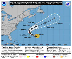
Paulette is expected to continue moving towards the northwest, intensifying into a hurricane tonight as southerly wind shear drops significantly over the next several hours. Conditions are expected to deteriorate in Bermuda on Sunday night, and Paulette is forecast by the National Hurricane Center to pass near or directly over Bermuda on Monday before being pushed towards the northeast by a trough moving across the eastern United States. Paulette is forecast to continue intensify as it moves away from Bermuda for another day or so before beginning to weaken. The National Hurricane Center is forecasting a 110 mph peak for Paulette- just below major hurricane intensity.
Bermuda is near-certain to experience winds of at least tropical storm-force winds, and the National Hurricane Center’s latest Wind Speed Probabilities give a 62% chance for Paulette to deliver sustained hurricane-force winds to Bermuda. Paulette is expected to deliver 3-6 inches of rain to the island. Preparations ahead of Paulette should be rushed to completion by tomorrow afternoon.
Tropical Storm SALLY
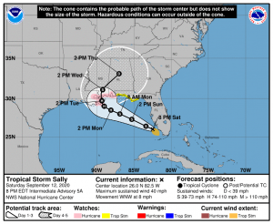
As of 20:00 EDT, Tropical Storm Sally was located near 26.0°N, 82.5°W, or about 45 miles west of Naples, FL with maximum sustained winds of 40 mph and a minimum pressure of 1003 millibars, moving WNW at approximately 8 mph. A hurricane watch is in place from Grand Isle, LA to the Alabama/Florida border, including Lake Pontchartrain, Lake Maurepas, and metropolitan New Orleans. A tropical storm watch is in place from the Alabama/Florida border extending eastwards to the Ochlockonee River.
In addition to these watches, New Orleans Mayor LaToya Cantrell has ordered mandatory evacuations for residents outside of the city’s levee system starting at 6:00 pm local time on Sunday. If you are under a mandatory evacuation order, it is STRONGLY ADVISED you heed it, and extremely dangerous to your health and safety if you proceed to ignore the order.
Sally is forecast to slowly move towards the northwest over the next couple of days as it rounds a weakening high pressure area before being picked up by a north-south ridge on Tuesday, which would likely cause Sally to crawl northwards as it makes landfall on the U.S. Gulf Coast that afternoon as a Category 1 hurricane, before then accelerating towards the northeast over the southeastern United States. Most models show Sally making landfall in southeastern Louisiana or Mississippi, however the landfall location may be as far east as the western portion of the Florida panhandle.
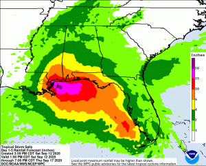
The National Hurricane’s Center Experimental Storm Surge graphic shows that portions of southeast Louisiana could potentially see 6-9 feet of storm surge, 4-6 feet for the Mississippi coastline, 2-4 feet for the Alabama coastline, and 1-3 feet throughout the Florida panhandle down to the Big Bend region of Florida- to the mouth of the Chassahowitzka river. The rainfall forecast has significantly increased over the past day or so, with several areas across the hurricane and tropical storm watches forecast to receive at least 10 inches of rain, and several isolated areas in extreme southeastern Louisiana are forecast to receive 15-20 inches of rain from Sally. Large areas of 6 inches of rain from Sally are forecast as far north as Interstate 20 in southeastern Mississippi and southwestern Alabama.
Elsewhere in the Atlantic (Tropical Depressions RENE and TWENTY)
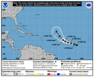
Further out in the Atlantic Ocean are the struggling Tropical Depression Rene, and the newly formed Tropical Depression Twenty. Both systems have maximum sustained winds of 35 mph. Rene is expected to dissipate in the next few days, and it’s remaining energy will drift southwestwards towards Puerto Rico and Hispaniola. On the other hand, Tropical Depression Twenty is expected to intensify into a significant hurricane in the Main Development Region, and is forecast to curve northwestwards away from the Greater and Lesser Antilles as it intensifies into a hurricane on Tuesday. The next name on the naming list for this year is Teddy.
