Potentially Historic Severe Weather Outbreak Today

The SPC has issued its second high risk in March
Today there is potential for a historic severe weather outbreak centered over the states of Mississippi, Alabama, and Tennessee. Understand that this is an incredibly dangerous situation evolving and that one needs to be ready to immediately activate tornado safety plans. The SPC noted the potential for “long-tracked, violent tornadoes” in their most recent Day 1 Convective Outlook. Violent tornadoes are rated EF4 or EF5 on the Enhanced Fujita scale, meaning they are capable of causing major damage to even well built homes and schools. As such, in the event of any tornado warning, treat the situation as if a violent tornado is moving towards your home and get to the most interior rooms or a basement in order to distance yourself from the tornadic situation. The SPC notes that the setup for this event is an “uncommon, upper-echelon parameter space,” so in the event of a tornado watch, a violent tornado could very well be approaching your location. Remember that your safety is the most important and you should not do anything that you feels compromises your safety.
Meteorologically, the setup for this event is extremely conducive to tornadoes. Multiple well-known parameters have skyrocketed for this event, and hodographs show large amounts of vorticity generating wind shear. The CAPE, or Convectively Available Potential Energy for this event has been augmented by warm air being entrained from the Gulf of Mexico and by incredible lapse rates in the middle atmospheric levels. All in all, the environment is conducive to the point where, even if this event takes the best case scenario, it may still merit a high risk.
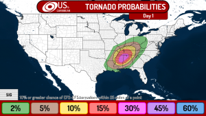
Early observed soundings from this morning have practically confirmed the NAM model’s prediction for extremely high lapse rates, while high CAPE is already building across the risk area. Understand that this is a rapidly evolving situation and the risk may change at any time, for better or for worse. It is still unknown exactly how the situation today will evolve, but even the most conservative scenarios from the models show a significant outbreak. Current guidance from the models show the supercells initiating across MS and AL around 1700 UTC, which is noon CDT and 1pm EDT. From here it is possible that the supercells organize into a somewhat linear formation that travels east until around 4pm CDT, where it is caught by another line of supercells initiating along the cold front behind it. The supercells then move eastward across TN, MS, AL, and GA, with possible supercellular activity as far north as IN. The highest risk will be concentrated in MS, AL, and southwestern TN, while lower levels of risk spread over a very large area extending from East Texas to Ohio.
Again, this is an extremely dangerous situation. Remember that your safety is above all else and not to make any decisions that could compromise it.
