Powerful Category 4 Hurricane Genevieve Expected to Impact Portions of the Baja California Peninsula Wednesday

Hurricane Genevieve has continued its long stretch of rapid strengthening, and is now a Category 4 major hurricane on the Saffir-Simpson scale. Genevieve is the seventh tropical storm, third hurricane, and second major hurricane of the 2020 Northeastern Pacific hurricane season. Environmental conditions are expected to support further rapid strengthening during the next 12 to 18 hours, and Genevieve is expected to make a close pass to the Baja California Peninsula, where tropical storm conditions are expected beginning Wednesday. By then, the cyclone will likely have lost some of its strength, but Genevieve is expected to still be a powerful hurricane through Thursday.
Hurricane Genevieve: Latest Storm Information
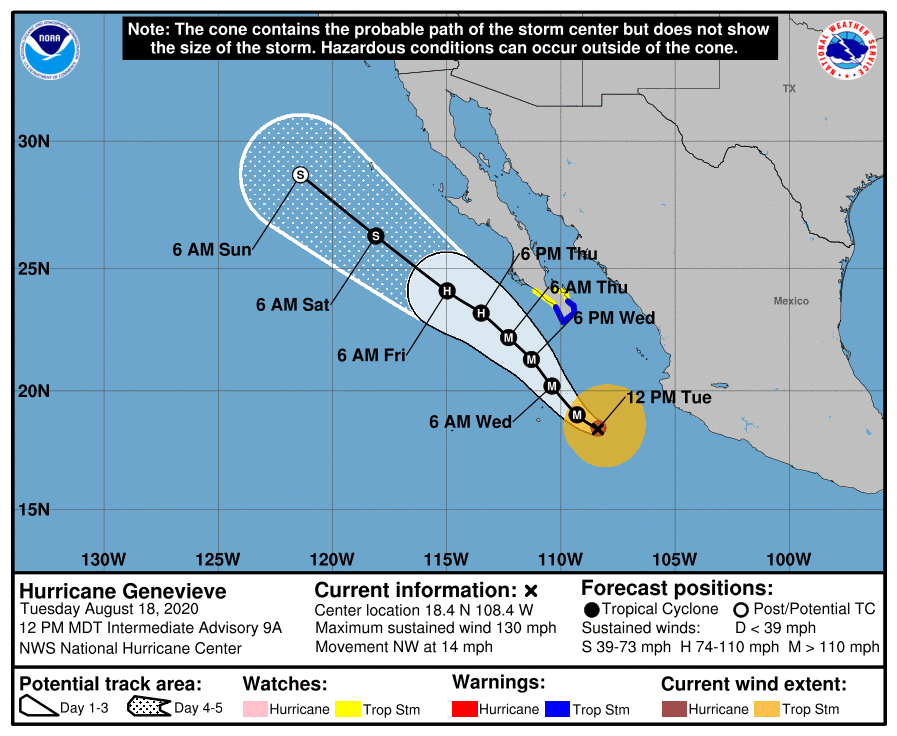
As of the National Hurricane Center’s most recent advisory on Genevieve at 8:00 AM PDT (15:00 UTC), the eye of Hurricane Genevieve was located near 18.4°N, 108.4°W, about 270 mi (435 km) west-southwest of Manzanillo, Mexico, and about 325 mi (525 km) south-southeast of the southern tip of the Baja California Peninsula. Maximum sustained winds are near 130 mph (215 km/h) with gusts to 160 mph (260 km/h), and the minimum central pressure is 950 mb (28.06 inches). Tropical storm-force winds extend outward up to 150 mi (240 km) from the center, and hurricane-force winds extend outward up to 30 mi (45 km) from the center. Genevieve is moving toward the northwest at around 14 mph (23 km/h), and a general northwestward motion with a decrease in forward speed is expected through Thursday. On the NHC’s forecast track, the center of Genevieve is forecast to move close to the southern Baja California Peninsula late Wednesday and early Thursday. Afterward, Genevieve is forecast to gradually accelerate on Friday, moving parallel to the coast of the Baja California Peninsula. Additional strengthening is forecast through the rest of the day and tonight before a gradual weakening is expected to begin Wednesday night. A more rapid pace of weakening should begin on Friday as Genevieve moves over cooler waters, and the cyclone should weaken to a tropical storm by early Saturday, and then likely degenerate into a remnant low by Sunday.
Forecast Track, Intensity Guidance, and Hazards Affecting Land
The dynamical model guidance remains tightly clustered in strong agreement on a continued northwestward track through the next several days, with a slower forward speed initially, and a faster forward speed later in the week as Genevieve is weakening. Genevieve will likely remain offshore as it moves northwestward, parallel to the Baja California Peninsula, with the closest pass expected to occur late Wednesday into early Thursday. The dynamical and statistical guidance does not indicate much additional strengthening, but given the impressive structure of the cyclone, the NHC forecast lies above the guidance, and calls for a peak intensity of 150 mph (240 km/h) within 12 hours. Weakening should begin by late Wednesday, but Genevieve should remain a powerful hurricane through Friday morning, after which time a more rapid weakening should commence.
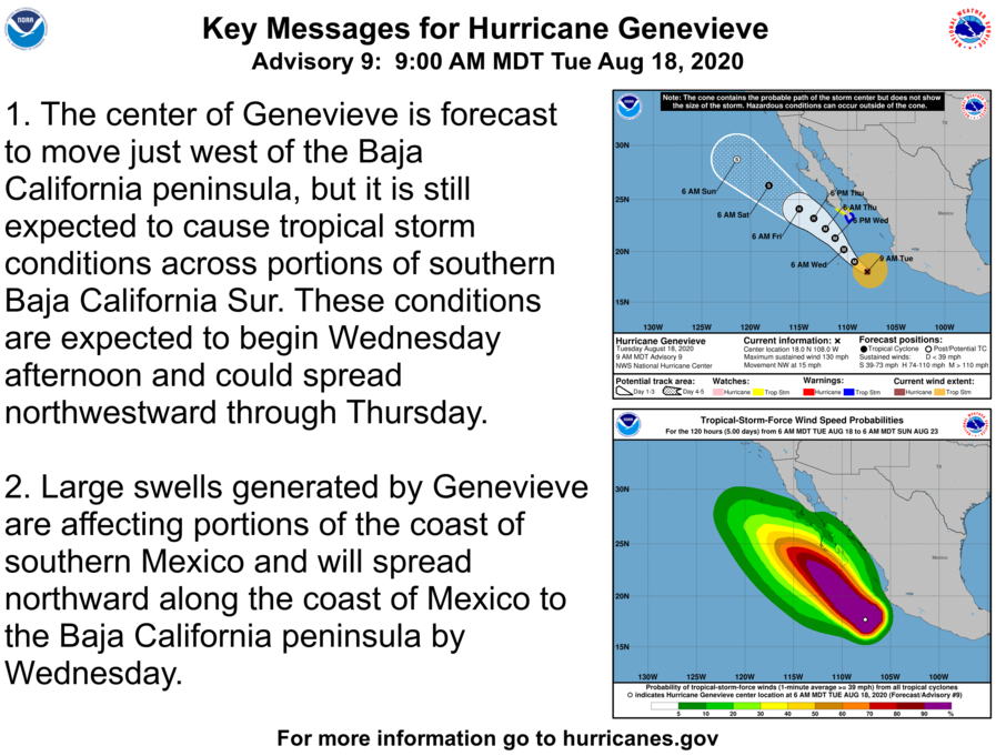
Although the center of Genevieve is forecast to move to the west of the Baja California Peninsula, tropical storm conditions are still expected to occur across portions of southern Baja California Sur. A Tropical Storm Warning is currently in effect for this area from Los Barilles to Todos Santos, while a Tropical Storm Watch is in effect from Puerto Cortes to Santa Fe. A Tropical Storm Warning means that tropical storm conditions are expected within the warning area within 36 hours, while a Tropical Storm Watch indicates the possibility of tropical storm conditions within the watch area within 48 hours. Large swells produced by Genevieve are currently affecting portions of the southern coast of Mexico and will spread northward along the southwestern and west-central coast of Mexico to the Baja California Peninsula through Wednesday. These large swells can create dangerous marine conditions for mariners as well as life-threatening surf and rip current conditions along coastal waters. Additionally, Genevieve is expected to produce rainfall amounts of 1 to 4 inches (25 to 100 mm) across portions of southern Baja California Sur and the southwestern coast of Mexico. This rain may result in life-threatening freshwater and flash flooding and mudslides, particularly in mountainous terrain. Please continue to refer to the National Hurricane Center and your local meteorological office for further information regarding Hurricane Genevieve.
External Links
Please refer to the National Hurricane Center and National Weather Service websites for further information regarding Hurricane Genevieve as well as watches and warnings in effect. Daily updates and Force Thirteen’s live satellite feed of Hurricane Genevieve can be found on the Force Thirteen YouTube channel at https://www.youtube.com/watch?v=6TFVWVMvELo. More information can be found at Force Thirteen’s official outlets, including its Twitter and Facebook pages.
