Remembering the 2011 Super Outbreak: April 14-24 “A Relatively Widespread/Multi-Round Severe Threat is Expected”

On Thursday April 14, 2011, the Storm Prediction Center (SPC) predicted that a significant severe weather outbreak would take place across the South in the coming days. A Moderate Risk for severe weather was issued for the next 2 days meaning that widespread severe storms-including numerous damaging and long-tracked tornadoes-seemed likely. Not long after that a line of supercells developed over Kansas and Oklahoma and swept east bringing tornadoes across the 2 states and Arkansas. This wave of storms swept South and on April 15 unleashed a powerful storm system over the Central Gulf Coast states of Mississippi and Alabama. Widespread EF-2 and EF-3 tornadoes touched down across the states causing intense damage and destruction. The following day a rare High Risk was issued for the North Carolina Coast meaning that a tornado outbreak is expected for the region. And indeed, one did occur as 53 tornadoes touched down across the state killing 23 people in one of the worst outbreaks in the state’s history. The system then moved into Canada while the front moved off the coast.
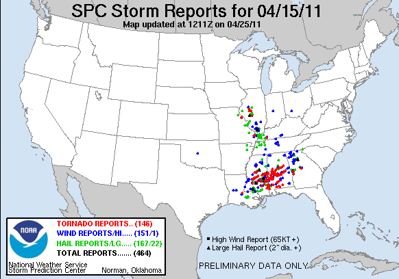
It was one of the country’s worst tornado outbreaks. 178 tornadoes had hit 16 states causing $2.1B in damages and killing 45 people in the deadliest outbreak since 2008. Entire communities had been affected with many large cities such as Jackson, MS, Raleigh, NC and Fayetteville, NC being especially hard hit. AccuWeather even stated that the outbreak was the largest number of tornadoes in a 3-day period in history. Surely this had to be the worst outbreak of the year, something like this wouldn’t happen for a while. Therefore, there was no need to panic and people went on with their lives helping clean up and begin repairing damaged areas. Little did people know this was just a taste of the horrors that would occur that tornado season, it was about to be much worse.
On Tuesday April 19, 2011, just 3 days after the April 14-16 tornado outbreak, the SPC stated on their day 4-8 outlook that a more amplified weather pattern seemed to be on tap for the Southeast on April 25 and 26 (days 7 & 8 on the outlook). When one goes more than 3 days out on model runs, very low congruency begins to occur. Because of this the SPC, with Day 1 being the day the outlook is issued (meaning it would be April 19 this day), bunches the Day 4-8 outlooks into one map and only issues a severe weather risk when there is a 30% probability of severe weather for an area which is very rare. During this day on this outlook, there wasn’t enough certainty to justify a risk so it was left with “Predictability Too Low” meaning just that.
On Wednesday, April 20, the SPC once again said that a very active pattern was likely over the Southern US in the coming days, though there wasn’t enough confidence to add a 30% risk. They stated that the main threat would probably be on the 25th to 28th (Monday-Wednesday) which would be widespread while a more limited event on the 24-25th but they stressed that there was still ample uncertainty on the event. Unknown to them, this forecast would become extraordinarily accurate in the coming days.
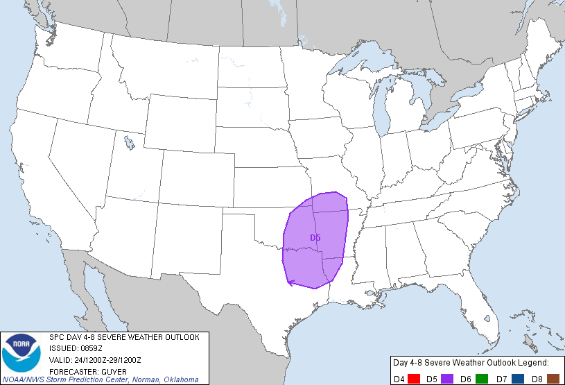
The following day on April 21, a 30% risk was added on the Day 5 (April 25) outlook for the ArLaTex region as well as for Eastern Oklahoma and Southwestern Missouri. The setup was that a weather system would pull moisture north into the Gulf Coast states which would make an unstable environment (meaning it would be very easy for thunderstorms to form in the area) that a cold front would interact with causing warm air to rapidly rise and form thunderstorms capable of producing severe storms, which as defined by the National Weather Service is thunderstorms which produce 58mph wind gusts or greater and/or hail the size of quarters (1″ in diameter) or larger and/or a tornado. These storms were likely to be very widespread that day. For the following 2 days, the SPC stated that “A relatively widespread/multi-round severe weather threat” was expected. There was still lingering uncertainty on where it would be which limited predictability and thus no highlighted areas were given.
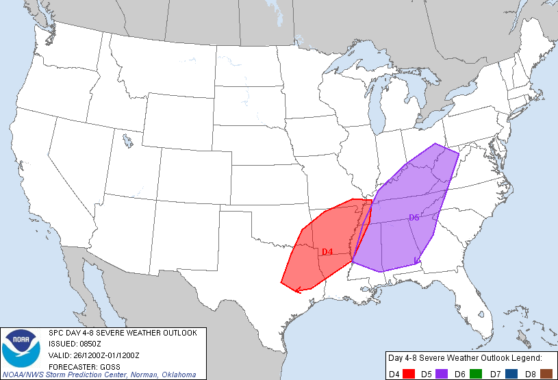
On April 22, another 30% risk was added for Day 5 (April 26) while the one for Day 4 (April 25) remained. They were both for similar areas centered over Arkansas but included areas of Eastern Texas, Northern Louisiana and Western Oklahoma with the Day 5 risk including extreme Western Tennessee and Mississippi. The first weather system was expected to have an enhanced tornado threat while the following a day a second weather system would likely bring another threat for severe weather over the same area with a similar threat. On April 27, the threat was harder to tell so no area was marked.
On Saturday, April 23, the SPC issued a Slight risk for severe weather for April 25. For the Day 1-3 forecasts there is usually more certainty to what to expect so the SPC will issue risks dependent on that threat which include a Slight risk (scattered severe storms are possible), a Moderate Risk (widespread severe storms are likely) or a High Risk (a tornado outbreak is expected). On the Day 1 and 2 outlooks the SPC also included a General Thunderstorms risk (thunderstorms, but no severe weather, are possible). The Slight Risk was mainly focused over the ArLaTex region and Eastern Oklahoma. Here a similar severe threat to that of April 14 was developing which included the risk for mainly large hail but also damaging winds and tornadoes. Meanwhile a 30% risk was added for both Day 4 (April 26) and Day 5 (April 27). Day 4 was similar to that of Day 3 with a threat mainly in the ArLaTex region but also extended to cover almost all of Arkansas and part of the Lower-Mississippi River Valley. Here, as instability was expected to continue to increase, large hail would once again be the main threat as well as damaging winds and tornadoes. But April 27 seemed to be the main day for the event. Here a large 30% risk spanned from the Gulf Coast to the Ohio River Valley and from the Mississippi River to the Appalachians. With ample destabilization a tornado environment seemed prime for this region. Past these day models diverged on what the front would do over the Mid-Atlantic states so no area was added. However, things would come into place the following day, April 24. This day a powerful weather system would begin forming and be the preshow the upcoming historic outbreak.
April 24
Morning Convective Outlooks

Models began to come in better agreement on what to expect for the following day of April 25. Because of this, the SPC issued a rare Day 2 Moderate Risk for a “Potentially significant severe weather event…with potential for strong tornadoes in addition to very large hail and damaging winds.” This Moderate Risk was over mainly over Arkansas but also parts of Southern Missouri. Here strong southerly flow was expected to make the environment very unstable and with strong, rotating winds in the atmosphere, it made conditions prime for tornado development. As the night progressed the threat was expected to turn more into a bow echo/more linear shifting the threat to more of a damaging wind threat with isolated tornadoes.
Here, some basic thermodynamics should be understood. For thunderstorms to form, warm air needs to be able to rise and form clouds. For something to rise it needs to be warmer/less dense than its environment. Air is the same way and to form thunderstorms must be always warmer than its environment through the atmosphere. The warmer an air parcel is to its environment, the easier it is to rise and form thunderstorms. This is called instability and how warm an air parcel is compared to its environment is called the convective available potential energy (CAPE) and is measured in joules per kilogram of air. For April 25, CAPE values were expected to be as high as 2000 but the estimate grew to 2500 that afternoon
For April 26 the SPC also stated that a “Complex — but potentially significant — scenario appears to be unfolding…” mainly across Arkansas, Northern Mississippi and Western Tennessee. Here moisture would continue to surge into the region and interact with a new weather system and a cold front. As wind shear (winds blowing in different directions and speed with height) would be strong and support rotation. As the cold front interacted with the environment, severe thunderstorms and tornadoes would rapidly form, with some tornadoes being quite strong. For April 27, the risk area hadn’t really changed but they expected the cold front from the previous to sweep through the region. Afterwards moisture would continue to surge into the region and with strong rotation, a “substantial severe weather” threat would be likely. damaging winds and hail as well as isolated tornadoes would be likely. Past this it became more uncertain so no area was marked.
Weather Event
A new low-pressure system began to develop over the Southern Rockies. This new low-pressure system began to produce powerful thunderstorms over Oklahoma and Texas prompting two Severe Thunderstorm Watches. These storms stretched on a line from Abilene, TX northwest toward just south of Tulsa, OK. They quickly became severe and began dropping large hail across the region. Just east of Abilene, thunderstorms began to suddenly become supercells (a thunderstorm with rotation that could form a tornado) and drop several tornadoes, including one that was reported to be a multi-vortex tornado. But as the night progressed, the storms over Texas began to weaken and dissipate while the ones over Oklahoma organized into a linear system and began to plow through Northern Arkansas. The low-pressure system continued to take shape and move north-west over Kansas. Meanwhile moisture was surging into the lower Mississippi River Valley and shear continued to rotate and strengthen.
The stage was set for the largest tornado outbreak in the history of the world.
Sources:
https://www.weather.gov/ffc/20110427_svrstorms
https://en.wikipedia.org/wiki/Tornado_outbreak_of_April_14%E2%80%9316,_2011
https://www.spc.noaa.gov/exper/archive/event.php?date=20110415
https://www.spc.noaa.gov/products/exper/day4-8/archive/2011/day4-8_20110419.html
https://www.spc.noaa.gov/products/exper/day4-8/archive/2011/day4-8_20110420.html
https://www.spc.noaa.gov/products/exper/day4-8/archive/2011/day4-8_20110421.html
https://www.spc.noaa.gov/products/exper/day4-8/archive/2011/day4-8_20110422.html
https://www.spc.noaa.gov/products/outlook/archive/2011/day3otlk_20110423_0730.html
https://www.spc.noaa.gov/products/exper/day4-8/archive/2011/day4-8_20110423.html
https://www.spc.noaa.gov/products/outlook/archive/2011/day2otlk_20110424_0600.html
https://www.spc.noaa.gov/products/outlook/archive/2011/day2otlk_20110424_1730.html
https://www.spc.noaa.gov/products/outlook/archive/2011/day3otlk_20110424_0730.html
https://www.spc.noaa.gov/products/exper/day4-8/archive/2011/day4-8_20110424.html
https://gis.ncdc.noaa.gov/maps/ncei/radar
https://mesonet.agron.iastate.edu/current/mcview.phtml?prod=usrad&java=script&mode=archive&frames=600&interval=5&year=2011&month=4&day=24&hour=0&minute=0
https://www.spc.noaa.gov/exper/archive/event.php?date=20110424
