Severe Tropical Storms In-fa and Cempaka continue to strengthen as both posing threat to land

Severe Tropical Storm In-fa now started moving West-Northwest as it approach the Southern Ryukyu Islands. As per the 3PM JST analysis of Force Thirteen, the storm is located at 24.6°N 131.3°E with 10-minute maximum sustained winds of 95 kph (50 knots) with minimum central pressure of 983 millibars.
Severe Tropical Storm Cempaka is currently stationary as it’s near Southeastern China. As per the 2PM ChST analysis of Force Thirteen, the storm is located at 21.0°N 113.2°E with 10-minute maximum sustained winds of 95 kph (50 knots) with minimum central pressure of 986 millibars.
[CURRENT WARNINGS]
In-fa
Shikoku
Ehime Nan-yo: High Waves, Heavy Rain (Landslide) Advisories
Northern Kyushu
Qita Central and Qita Southern Regions: High Waves, Heavy Rain (Landslide) Advisories
Qita Western Region: Heavy Rain (Landslide) Advisory
Southern Kyushu
Miyazaki: Plain Area of Southern Region: High Wave and Heavy Rain (Landslide) Advisories
Miyazaki: Plain Area of Northern Region: Heavy Rain (Landslide) Warning; High Wave, Flood, and Heavy Rain (Inundation) Advisories
Miyazaki: Area long mountains of Southern Region: High Wave and Heavy Rain (Landslide) Advisories
Miyazaki: Area long mountains of Northern Region: Heavy Rain (Landslide) Advisory
Kagoshima: Satsuma and Osumi Regions: Storm Gale and High Wave Advisories
Kagoshima: Tanegashima Yakushima Region: High Wave and Heavy Rain (Landslide) Advisories
Kagoshima Amami Region: High Wave Advisory (With a high probability of a subsequent Warning (Except Storm Surge))
Okinawa
Okinawa Northern, Central, and Southern Main Island: High Wave Advisory (With a high probability of a subsequent Warning (Except Storm Surge))
Okinawa: Kumejima Region: High Wave Advisory
Okinawa Daitojima Region: High Wave Warning, Storm Gale Advisory
Okinawa Miyakojima Region: High Wave Advisory
Cempaka
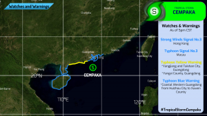
Macao, China SAR: Signal No. 3 is now in effect starting 14:30 ChST.
Hong Kong, China SAR: Strong Wind Signal No. 3 is in force starting 16:10 HKST. This means that a tropical cyclone now centered within about 800 kilometers of Hong Kong may affect the area.
People’s Republic of China
Yellow Typhoon Warning: Taishan City, Yangjiang City, Yangxi County, Coastal Western Guangdong
Blue Typhoon Warning: Coastal Western Guandong Province from Huizhou City to Xuwen County
[FORECAST]
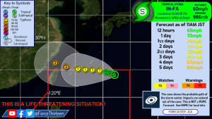
In-fa is expected to continue to strengthen and be a Typhoon within 36 hours. It will moves toward the Ryukyu Islands. It’s expected to gain more latitude nearing Taiwan and move NW towards Fújiàn and Zhèjiāng Provinces. Possible life-threatening rainfall over Taiwan and the Ryukyu Islands. Strong winds are also affected on the said areas.
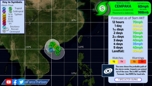
Cempaka is expected to move slowly towards Southeastern China near Macao and Hong Kong potentially as a Typhoon. Afterwards, it expected to turn back and move towards Hainan and strengthen as it re-enters the South China Sea. Heavy rain and squalls are expected in the vicinity of the Pearl River delta.
