Severe Weather Going to Impact Millions This Weekend

A huge low-pressure frontal system is going to make its way across the US not only affecting the south with Severe Weather but also the north with ice and snow. Millions are in the way of this system and should be prepared in case of any inclement weather from this system. The NWS SPC outlooks give high chances of severe weather for Day 1 and 2, and it will affect millions including NOLA, Birmingham, Atlanta, Oklahoma City, and San Antonio to name a few. You might be wondering what are the chances of severe weather for me, and if I am in one of those locations what should I do to prepare for the severe weather or even the worse. Don`t worry that is what this article is here to tell you.
Day 1(Friday)
Today will be the spawning of the system, and the severe weather will mainly affect Louisiana, Texas, Arkansas, and Oklahoma. While in the north severe snow and ice will affect Missouri, Iowa, Illinois, and Wisconsin. This system will be double hitter, and that`s why this article is going to be divided between the Northern and Southern U.S. because each area will experience different situations.
Southern U.S. Day 1 (Texas, Oklahoma, Mississippi, Arkansas, Tennessee, and Louisiana)

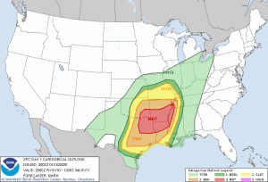
The SPC Day 1 outlook showing a full day of severe weather for people from Texas to Missouri. If you are in the orange area or red areas please take shelter if there is any tornado threat near you and be cautious of the high winds and hail. Remember tornadoes aren`t the only killer because high winds hail can be just as deadly if people do not take the right precautions. The chances for day 1 are Hail 30%, Winds 45%, and Tornado 15%, so anyone in the highlighted areas please keep updated with your local weather service and takes some extra precautions.
Northern U.S. Day 1(Missouri, Iowa, Illinois, Wisconsin)

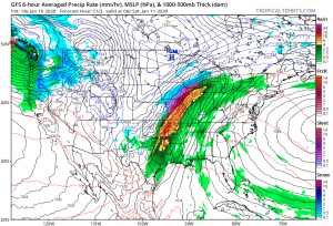
Not only is this system a severe weather threat, but it is also a severe winter storm in the north which could have black ice, which super dangerous when driving, and tons of snow possibly keeping some people in their homes. Overall, the winter storm is nothing to take lightly and if you are in those blues or pinks you should prepare for tons of snow and ice.
Day 2(Saturday)
Tomorrow is potentially going to be less dangerous, but you should always prepare for the worse in case tomorrow is as severe as today. Michigan will experience wretched conditions from the snow and ice, and the south will experience more severe weather as the system continues to push east.
Southern U.S. Day 2(Louisiana, Mississippi, Tennessee, Georgia, Kentucky, Florida)

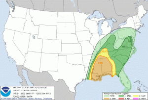
Louisiana, Mississippi, Alabama, Tennessee, Georgia, and Florida are going to experience the worst of the severe weather for day 2. It is most likely not going to be as tornado driven as today but high winds and hail will make for inclement weather tomorrow. If you are in one of the highlighted areas you should take a look at your local weather service, and look at what safety precautions you should take and make safe decisions, so you do not get hit off guard by this.
Northern U.S. Day 2(Wisconsin, Michigan, Indiana, Illinois)
Michigan is most likely going to get hammered by this system especially Detroit by all the ice and snow that could pile and make some roads not able for people to drive on. It is not only Michigan, but it is also Northern Indiana, North Eastern Illinois, and Wisconsin. If you live in any of those location please look at your local weather service and make a plan in case of the worst.
Summary
The severe weather this weekend will affect millions and if you are in one of the locations I talked about in the article you should keep a close eye on this developing situation so in case of the worse you have cut in stone plan. The most important thing to do right now will be to check your local weather service. Also, if you want some more in-depth coverage from Force Thirteen go check out Force Thirteen U.S https://www.youtube.com/channel/UCYXSc1C38hfe6QFR6moVGIw for more coverage from our team.
Works Cited
- http://spc.noaa.gov “Products, Outlook, Day 1” https://www.spc.noaa.gov/products/outlook/day1otlk.html Accessed 10 Jan. 2020.
- https://www.tropicaltidbits.com/ “Forecast Models, GFS, 18z Friday Jan 10, CONUS, Forecast Hour 12, MSLP and Precip (Rain/Frozen)” https://www.tropicaltidbits.com/analysis/models/?model=gfs®ion=us&pkg=mslp_pcpn_frzn&runtime=2020011018&fh=30 Accessed 10 Jan. 2020.
- http://spc.noaa.gov “Products, Outlook, Day 2” https://www.spc.noaa.gov/products/outlook/day2otlk.html Accessed 10 Jan. 2020.
