Severe Weather Outbreak Possible This Afternoon

The SPC's forecast risk areas for this afternoon, the 4th of May
In its 11:30AM CDT update, the NWS Storm Prediction center upgraded severe risk for this afternoon and evening to Moderate for areas in the Southeast US. This risk level signifies strong and severe thunderstorms are likely, where severe is defined as a thunderstorm having at least 58mph gusts, 1 inch hail, or a tornado.
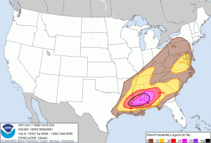
The current SPC outlook calls for the population centers of Hattiesburg, MS, Meridian, MS, Pearl, MS, Brandon, MS, and Laurel, MS to be encompassed within the Moderate risk level. This risk is driven by a 45% chance of severe winds (58mph) under a 10% chance of significant severe winds (74mph), as shown on the right. The 45% wind risk of 58mph gusts also extends into central Alabama, encompassing the population center of Prattville, and is producing a forecast Enhanced risk in those areas. The significant severe wind threat also extends marginally farther than the 45% wind threat to the east, and is producing Enhanced risk in those areas as well. The 30% wind threat encompasses the rest of the Enhanced risk area, with cities such as Birmingham, AL, Baton Rouge, LA, and Mobile, AL within. Lower wind risk extends farther and a 5% encompasses most of the Southeast US as well as some mid-Atlantic states including Virginia, West Virginia, Maryland, Delaware, and Pennsylvania. An isolated area of 15% wind risk also extends through most of eastern Virginia.
A 5% hail threat is forecast over much of the same area as the wind threat, with a smaller 15% area following the lower Mississippi Valley and the Ohio river up to the middle of Kentucky. This 15% hail threat also extends west of the southernmost portion of the Mississippi into Texas. A tornado risk is also forecast, with a 2% tornado risk extending through the same areas as the 15% wind risk. There is also a 5% tornado risk encompassing Birmingham, AL, Montgomery, AL, Mobile, AL, Baton Rouge, LA, and Jackson, MS. All risks are based on the possibility of a severe event occurring within 25 miles of a point
The storm mode today is likely to transition quickly into a rather strong quasi-linear convective system, possibly a derecho, after rapid upscale growth after the initiation of cells in the threat sector. High dewpoints exceeding 70 degrees Fahrenheit and strong shear will support organized storm development in the area, with the SPC noting the possibility of multiple mesoscale convective systems developing during the event. Supercells are still possible in the early stages of the event if isolated initiation occurs, while tornadoes can still occur within the main QLCS.
Remember that a Moderate risk means you should be on guard to take cover in the event of a severe thunderstorm threat, and the high wind threat means you should not be outside of a sturdy shelter when the main QLCS passes over. For more information, watch your local weather station and monitor your local NWS office.
