Significant Severe Weather Likely Across the Deep South Today

A significant severe weather event is once again unfolding in the Southern United States today as a strengthening trough pushes eastward across the continent. Multiple episodes of severe thunderstorms will be capable of producing all kinds of severe weather, including strong and potentially long-tracked tornadoes, widespread damaging wind gusts, and large hail. The greatest threat is expected across eastern Texas into the Mississippi Delta and eastward into Alabama and central Georgia, where the Storm Prediction Center (SPC) has issued a “Moderate” risk of severe thunderstorm activity.
Individual Threat Synopsis
Tornado
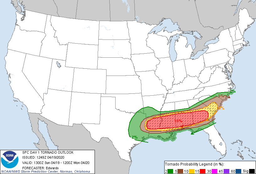
Supercells developing near a warm front situated over the risk area will pose a risk for tornadoes today, some of which may be strong and long-tracked. Across the “Moderate” risk area, the SPC has also outlined potential for significant (EF2+ on the Enhanced Fujita Scale) tornadoes from eastern Texas eastward into central Georgia and southern South Carolina. The primary tornado threat during the afternoon and evening hours will come with supercell development near a warm front positioned over the risk area. From tonight into tomorrow morning, a mesoscale convective system sweeping eastward will bring an additional tornado threat along with the potential for widespread damaging winds. Tornadoes may develop rapidly from severe thunderstorms and can produce significant structural damage across their paths. If a tornado warning is issued for your area, take cover in the nearest substantial shelter immediately; do not wait to hear or see the tornado. Be sure to have an emergency kit with you if neccessary.
Wind
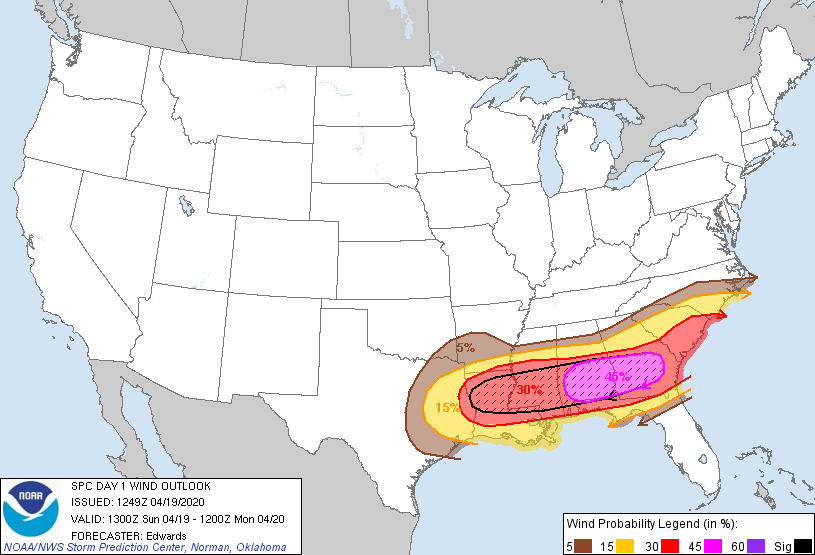
Any severe thunderstorm developing within the risk areas may be capable of producing damaging wind gusts. Across the “Moderate” risk area, the SPC has outlined potential for wind gusts of 65 kt (75 mph) or greater within 25 miles of a point, with the greatest wind threat in central Alabama and Georgia. The greatest wind threat will arrive later today as a mesoscale convective system sweeps eastward across the risk area. Strong winds are particularly dangerous to structures, vehicles, and people and animals outdoors. Unsecured light objects may become projectiles, and damage to roofs, siding, windows, and vehicles is likely with damaging winds. For your and others’ safety, clear your property of any small and light objects which could become projectiles in the event of damaging winds from a severe thunderstorm.
Hail and Heavy Rainfall
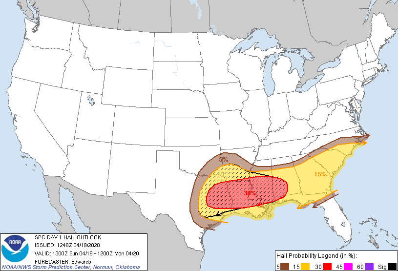
The greatest hail threat today will come this morning into the afternoon hours primarily with individual thunderstorm cells. The greatest hail threat exists from eastern Texas northward into central Arkansas and eastward into central Mississippi and Alabama, where the SPC has outlined potential for two inch diameter hail or larger within 25 miles of a point. Hail is particularly dangerous to vehicles and people and animals outdoors. The threat for large hail will diminish this evening into Monday morning as a mesoscale convective system becomes the dominant storm mode.
Additionally, heavy rainfall is expected across much of the Southern United States as the parent trough and associated fronts sweep eastward across the region through Monday afternoon. With heavy rainfall comes the threat for freshwater and flash flooding, primarily across the risk area, where rainfall totals will be greatest. Flash Flood Watches are already in effect from portions of Louisiana eastward into central South Carolina. Flash flooding is a very dangerous situation. Never attempt to walk or drive into a flooded area, the water may be much deeper than it appears. If flash flooding is occurring, move to higher ground and stay away from the flooded area. Ensure that you have taken proper precautionary measures and have an emergency plan in action in case basic utilities become inaccessible.
For further information regarding today’s severe weather event, visit the National Weather Service (NWS) on the web at www.weather.gov. Refer to your local National Weather Service office for the latest information, watches, warnings, and advisories. Force Thirteen will be providing live coverage of today’s severe weather event on the Force Thirteen US YouTube Channel. Stay tuned to your local NWS office and to Force Thirteen’s outlets as this severe weather event unfolds.
