Remembering Mount Pinatubo 30 Years Later

Mount Pinatubo erupted multiple times from 1991 and 1992, causing one of the most historical and devastating volcanic eruptions of the 20th century, coupled by a typhoon that further amplified its devastation.
But how did people find out that it was a volcano?
How did people respond to the impending volcanic threat?
How often can this type of eruption occur?
And what can we learn from this monster of a volcano?
It all started back in early 1991 where the indigenous Aeta Negrito tribal communities lived on the slopes of Mount Pinatubo.
The Aetas believed that one of their deities, Apung Malyari, lives in Mount Pinatubo, and they felt that it was their duty to guard the mountain.
(Credit: Raymundo Punongbayan/PHIVOLCS)
First Signs
On August 3rd, 1990, 2-3 weeks after the 1990 Luzon earthquake that struck Cordillera and devastated many people’s livelihoods, ground fracturing and steam emissions were reported by residents of Sitios Tarao and Yamut on the upper slopes of Mount Pinatubo.
This event signalled magmatic or hydrothermal activity yet no one thought that this would lead to an eruption at the time.
On March 15th, 1991, the Aetas, on the lower north-western flank of Pinatubo, felt earthquakes that could have originated from Mount Pinatubo.
Then in the following month of April 2nd, steam explosions, coming from the mountain, were witnessed by many within the tribal community.
Two days later on April 4th, Sister Emma Fondevilla of LAKAS reported these explosions to the Philippine Institute of Volcanology and Seismology (or PHIVOLCS); she also reported felt earthquakes and a strong sulfur odor during and after the explosions.
The series of explosions and the strong sulfur odor caused some residents of villages at the northwest, west, and southwest slopes of the volcano to evacuate voluntarily.
PHIVOLCS began to become more concerned regarding these reports, but could they trust the accounts of a people who believed in make believe deities living in the mountain?

(Credit: Raymundo Punongbayan/PHIVOLCS)
Punongbayan’s Assessment
PHIVOLCS, under the guidance of one of the world’s best volcanologists Raymundo Punongbayan, deployed scientists to install seismographs near Mount Pinatubo to determine whether these accounts were true.
In the first 24 hours after the seismographs were deployed, more than 200 small and high-frequency earthquakes were recorded.
These were not your average tectonic earthquakes, these were volcanic earthquakes.
On April 7th, PHIVOLCS stated that Mount Pinatubo was a volcano and that its condition was unstable.
A 10 km danger zone around Pinatubo’s summit was created.
Around 5,000 indigenous Aetas were evacuated from the volcano due to the enforcement of the danger zone, yet some stayed as they felt that leaving would be like betraying their deity, Apung Malyari.
(Credit: Raymundo Punongbayan/PHIVOLCS/USGS)
Frequent Earthquakes and Reconnaissance
Throughout the months of April and May, around 30-180 high frequency earthquakes occurred per day and the volcano’s condition remained unstable.
Around late April, a team from the USGS joined PHIVOLCS at an apartment in Clark Air Base.
This apartment would later be known as the Pinatubo Volcano Observatory (PVO).
Reconnaissance was sent by the PVO to look at the magnitude of past eruptions and this provided an insight into the behavior of Pinatubo: large explosive eruptions separated by repose periods lasting millennia.
Three most recent major eruptions happened around 500, 3k, and 5.5k years ago.
Daily bulletins and special advisories were provided about Pinatubo throughout the entirety of the unstable condition of the volcano.
(Credit: Force Thirteen/PHIVOLCS)
Ads by 
Alert Levels and Magma Activity
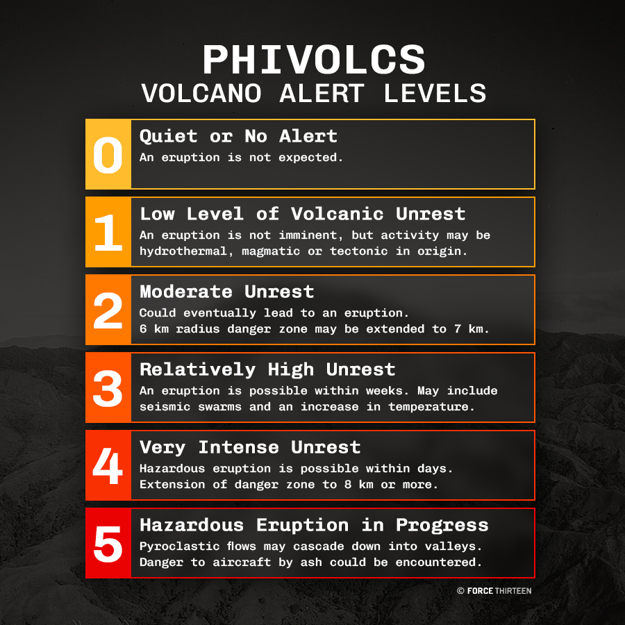
On May 13th, 1991, PHIVOLCS released Alert Levels for Pinatubo, which they have done for other volcanoes like Taal.
These Alert Levels range from 1-5, depending on the activity of the volcano.
Alert Level 2 was issued on the same day, meaning probable magmatic intrusion that could eventually lead into an eruption.
The 10 km danger zone was reiterated with this Alert Level being raised.
The earthquakes around the volcano remained relatively shallow and less than Magnitude 2.5.
These earthquakes were too small to be felt except by people near the areas where the earthquakes were.
Meanwhile, sulfur dioxide emissions began rising near the summit from 500 tonnes/day on May 13th to more than 5,000 on May 28th.
The data at the time suggested that the magma beneath Pinatubo was going in a more shallow area sufficient for substantial degassing of toxic volcanic gas.

(Credit: John Ewert/USGS)
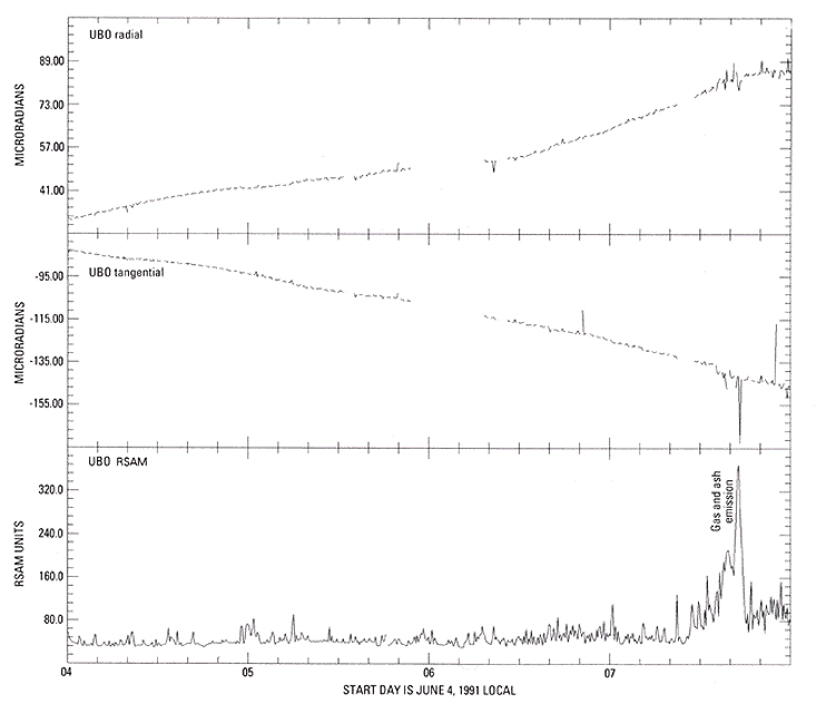
An electronic tiltmeter was installed on the eastern flank of the volcano during late May.
The month of June arrived and on June 1st, a second swarm of shallow earthquakes was recorded around the area of fuming vents.
These earthquakes signalled rising magma trying to forcefully open a conduit between Pinatubo’s magma reservoir underneath and the surface.
The rate of SO2 emissions had also dropped from 1,800 tonnes/day on May 28th, to 260 on June 5th.
This may have signalled that the passages where the gases were getting out of were getting sealed, and that rapidly increasing pressurization and an imminent explosive eruption might ensue.
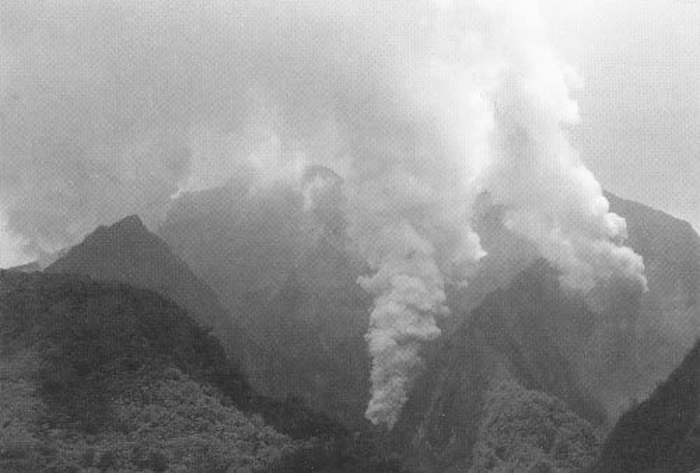
On the evening of June 3rd, a small explosion rocked Pinatubo with an increasing level of unrest characterized by increasing seismicity beneath the vents, harmonic tremor, minor emission of ash, and a gradual outward tilt on the tiltmeter in the volcano’s eastern flank.
After 2 days, Alert Level 3 was raised for Mount Pinatubo signalling that an eruption is possible within 2 weeks.
The 10 km danger zone was still maintained for the volcano.
(Credit: USGS)
The electronic tiltmeter on the eastern flank of Mount Pinatubo had accelerated outward tilt at noon June 6 along with increased seismicity until June 7 when increased emission generated a column of ash and steam around 7 to 8 km high.
After that, seismicity had decreased and the accelerated outward tilt had stopped.
PHIVOLCS then announced Alert Level 4 which meant that an eruption was possible within 24 hours.
The danger zone was extended to 20 km and included more civilians to be evacuated.
The outward tilt and the shallow seismicity suggested that a shallow conduit was being developed in order to be transported to the surface.
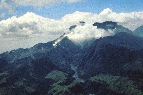
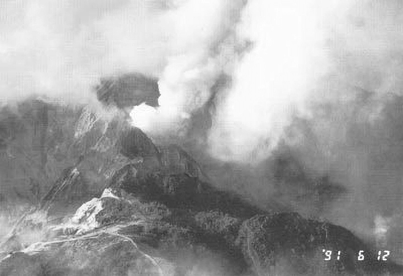
This was confirmed when witnesses the next morning saw a 50m-100m diameter lava dome northwest of the summit.
Aerial observations, despite extremely poor visibility due to venting steam and tephra, indicated that the lava dome had kept expanding until June 11.
(Credit: USGS)
Volcanic Escalations and Military Evacuations
The south-eastern section was destroyed by vertical eruptions on June 12-14.
The dome margin, despite destruction, had continued to expand westward.
The last time it was seen (June 14, a day before the cataclysmic and climactic eruption), the dome was flat-topped and spanned the upper Maraunot River valley.
This expansion may have been caused by continued extrusion or post-extrusion flowage as the dome lava continued to move downwards under gravity.
The period from June 8 to early June 12 was marred with increased ash emissions from Pinatubo, more swarms of shallow earthquakes beneath the dome, and continued episodes of harmonic tremor.
The wind carried the ash plume westward.
At times, dilute ashy density currents flowed down the upper Maraunot valley.
These dilute ashy density currents resembled ash clouds commonly associated with pyroclastic flows, but they never coincided with seismic explosion signals nor had any recognizable flowage deposits marking their tracks.
(Credit: USGS)
PHIVOLCS, seeing the continued escalation of volcanic unrest and observation of these dilute ashy density currents had prompted them to raise Alert Level 5 on June 9th meaning that an eruption was in progress.
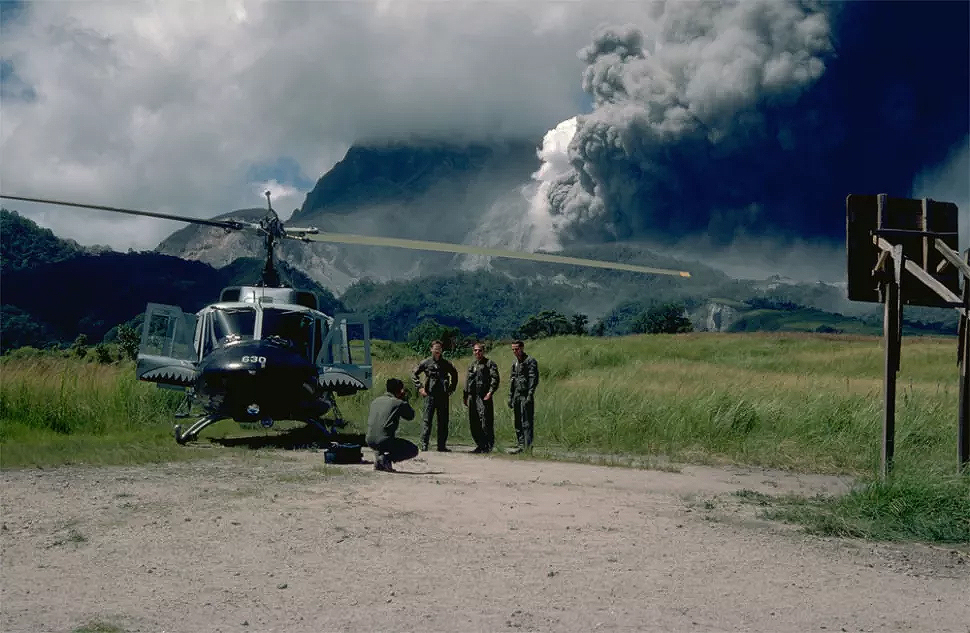
On June 10th, 14.5k American military personnel and other relatives had evacuated Clark Air Base and travelled to Subic Bay Naval Base.
All remaining aircraft except 3 helicopters had also left Clark in the same day.
Around 1.5k American and nearly the same amount of Filipino troops had remained behind to provide base maintenance and security.
The PVO had remained the base however moved their headquarters to a building 25 km away from the summit near the east end of Clark Air Base.
They had continued monitoring Pinatubo’s unrest from there.
Tremors and Eruptions
(Credit: USGS)
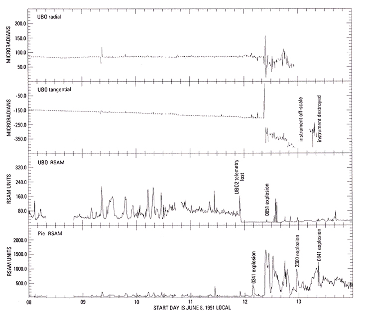
A large burst of intense seismic tremor had occurred on June 12 at 3:10AM.
High magnitude tremor persisted for around 40 minutes.
Although the magnitude gradually had decreased, it had returned back to background level more than 2 hours after it began.
A small eruption signal with an onset time of 3:41AM (noting that seismic-drum records had recorded uncorrected local time) had been embedded in the tremor episode.
No tephra fall was reported during this signal, however this could have coincided with increased ash emission.
As the sun rose, a plume of steam and ash had been rising 3 kilometers above the volcano, higher than what had been observed during the past few days.
Aerial observations had shown that small pyroclastic flows had coursed down the uppermost Maraunot and O’Donnell drainages which had spawned small lahars.

(Credit: USGS)
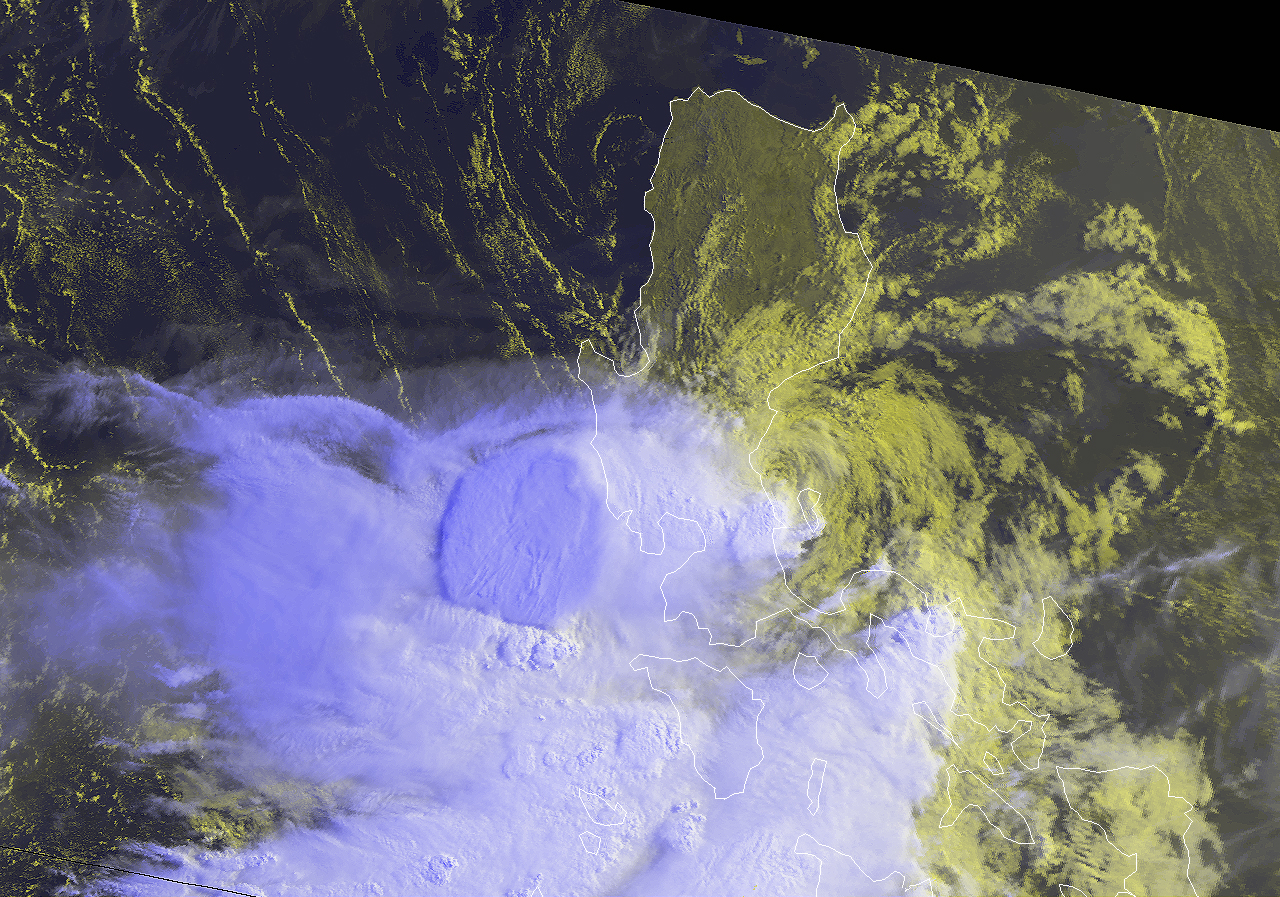
Meanwhile in the Philippine Sea, a Tropical Cyclone Formation Alert had been issued for a tropical disturbance that would later be known as Typhoon Yunya.
A major explosive eruption had occurred at 8:51AM.
Seismicity had increased in just a few seconds from a low-amplitude tremor to a high-amplitude signal that had saturated records of all seismic records.
The high-amplitude signal and rise of the eruptive column had began simultaneously.
Ash from this eruption had been transported southwestward past communities north of Subic Bay, and a small pyroclastic flow travelled northwest from the vent in the headwaters of the Maraunot River.
This was the first and the longest out of four eruptions that had been occurring from June 12-14, 1991.
The others had occurred at 10:52PM at the same day, 8:41AM at June 13, and 1:09PM at June 14.
Ground-based observers at Poonbato had reported seeing pyroclastic flows at each of the 3 daytime eruptions and low tephra plumes have been seen over the vents following the 8:51AM June 12 and the June 13 eruptions.
Explosion plumes seen from the air along the upper 5 km of the Maraunot River valley after the 8:51AM June 12 eruption provided indirect evidence of new pyroclastic-flow deposits, but poor visibility prevented direct observation of the deposits themselves.
Another observation flight shortly before the 1:09PM June 14 eruption documented new pyroclastic-flow deposits in the upper Maraunot valley.
Later ground-based observations about 3.5 km downstream from the position of the 1991 dome showed deposits of only two pyroclastic flows beneath the June 15 deposits in the Maraunot valley.

(Credit: USGS)
The Danger Zone Extension
On June 14, the danger zone had been extended to 30 km and the number of evacuees had increased to 85k.
600 of the 1.5k remaining American soldiers at Clark Air Base had been evacuated.
North-easterlies had prevailed during the eruptions which had caused tephra to fall southwestward across Subic Bay and nearby communities.
No tephra had been recorded in Clark Air Base.
Unlike the initial eruption at 8:51AM on June 12, the eruptions at 10:52PM on June 12 and 8:41AM on June 13 were preceded by 2-4 hour swarms of long-period earthquakes which made it easier for the PVO to issue explicit warnings in advance.
The resumption of this pattern during the evening of June 13 had suggested that another eruption would be imminent however none occurred as expected.
The pattern had changed to one where long-period earthquakes had continued hour after hour.
A sequence of 13 explosive eruptions began shortly after the 1:09PM eruption on June 14 and continued for nearly 24 hours.
These became more closely spaced as time progressed and apparently reflected pyroclastic-surge production.
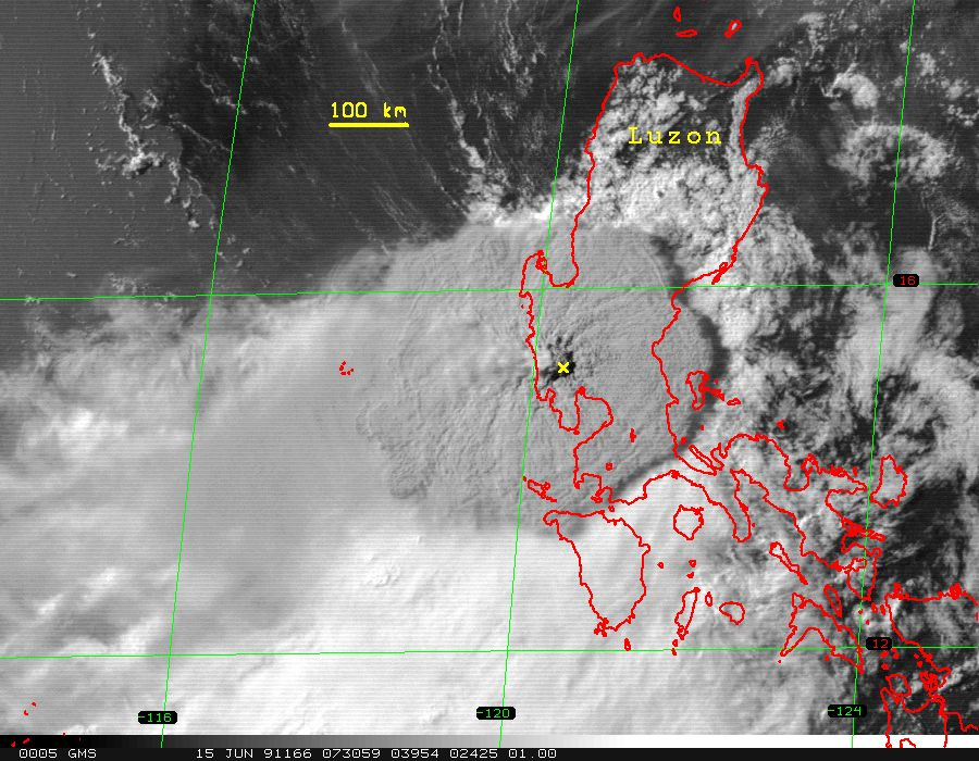
Tropical Cyclone Yunya
(Credit: NOAA)
Meanwhile, Yunya had rapidly organized and became a Category 3 typhoon east of Luzon.
However, strong wind shear had continued to weaken this small system and once it made landfall, it became a minimal typhoon and weakened into a tropical storm once land interaction occurred.
Deteriorating weather conditions related to the approach of Typhoon Yunya obscured the view of Mount Pinatubo from Clark Air Base so that only one of these events (at 5:55AM June 15) was seen directly from Clark.
Several were seen, however, by observers to the northwest at Poonbato and to the north at Camp O’Donnell.
In addition, two night eruptions (11:20PM on June 14 and 1:15AM on June 15) were recorded by an infrared-imaging device at Clark Air Base.
All views were of large pyroclastic density currents sweeping the volcano’s flanks.
(Credit: Robert LaPointe/USAF)
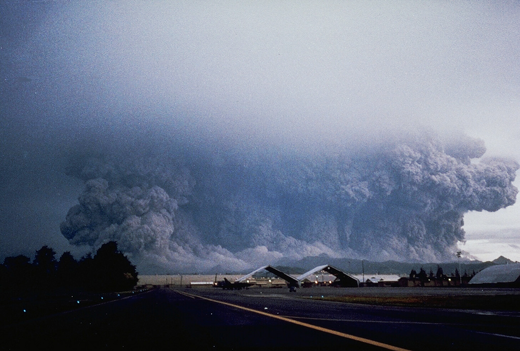
The Big Event
The cataclysmic and climactic eruption occurred at 1:42PM and had initiated continuous high-amplitude tremor and had initiated 9 hours of atmospheric pressure variation and ash with pumice fragments as large as 4 cm in diameter that was falling at PVO.
A 40-km wide danger zone had been in place, the highest that has ever been placed by PHIVOLCS during the 1991 Mount Pinatubo eruption- This included 17 towns.
The PVO team and the rest at Clark Air Base were forced to evacuate at around 3:00PM in pitch black darkness.
Large earthquakes had occurred varying from Magnitude 4.3 to 5.7. These earthquakes may have recorded caldera formation.
There have been 29 of these earthquakes within the first 6 hour period of the eruption.
(Credit: JMA/GMS-4)
The eruption cloud expanded to 400 kilometers wide at around 3:55PM and shadow measurements around the white clouds suggest that the altitude was about 25 kilometers at the eastern edge and 34 kilometers at the center.
Mount Pinatubo’s present caldera had formed from around 4:30PM when volcano-tectonic activity had increased to 10:30PM when the climactic eruption ended.
The PVO team went back to Clark Air Base and re-established seismic monitoring at June 16.
The seismicity of the volcano had decreased for the next 2 months.
The climactic eruption left open a vent system where ash kept billowing in the caldera for another month.
Plumes at times reached 18 to 20 kilometers tall. Winds caused significant ashfall, especially southwest and northeast of the new caldera.
Alert Levels have been downgraded gradually from Alert Level 2 as the volcano was reeling from its climactic eruption.
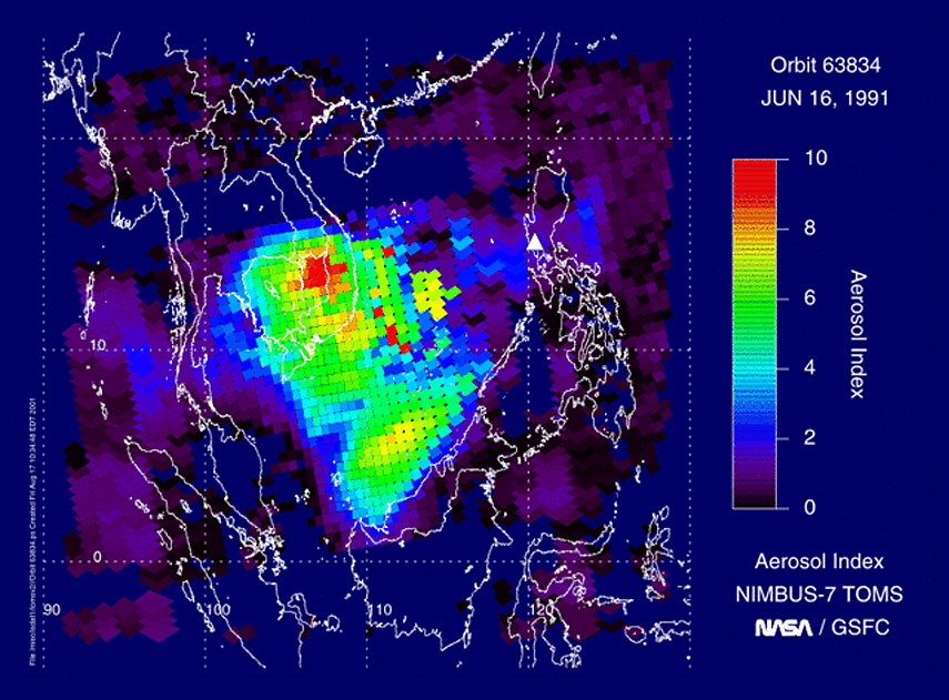
(Credit: NASA/GSFC/NIMBUS-7)
Disruption
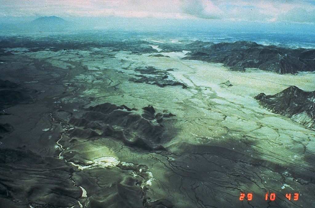
Mount Pinatubo’s lahars have caused severe economic and social disruption.
It has kept striking Central Luzon during the SW monsoons of 1991 and 1992.
Numerous secondary explosions occurred during the 1991 and 1992 monsoon seasons from the interaction of water with hot pyroclastic-flow deposits.
A lava dome formed within the new summit caldera from July through October 1992.
Its emplacement was heralded by increasing earthquakes and tremor in early July.
By July 9, explosions near the center of the caldera lake had built a low pyroclastic cone that was about 70 to 100 m across and extended 5 m above the lake surface.
Alert Level 3 was raised by PHIVOLCS with a 10-km danger zone.
Captured on June 29th, 1991.
(Credit: Ed Wolfe/USGS)
Lava extrusion had ensued, by July 14, a lava dome was about 5 to 10 meters high and 50 to 100 meters in diameter which had grown in the pyroclastic cone that had widened to 150 meters.
Alert Level 5 was raised while maintaining the 10-km danger zone.
By July 23, the lava dome had buried the pyroclastic cone.
Dome growth continued through October marked by the formation of a succession of extrusive lobes and accompanied by intense swarms of shallow earthquakes.
A sharp drop in seismicity in October 31 had marked the end of the 1992 lava dome growth.
The Alert Level was downgraded to 2 on December 9th of 1992, maintaining the 10-km danger zone.
In Summary
The 1991 eruption of Mount Pinatubo was the world’s largest in more than half a century and probably the second largest of the century.
Its roughly 5 km3 of erupted magma is an order of magnitude greater than the volume of magma erupted in 1980 from Mount St. Helens but is smaller than the 13+-3 km3 of ignimbrite and fall deposits from the 1912 eruption of Novarupta, Alaska.
Pinatubo measured VEI 6 on the Volcanic Explosivity Index.
Usually eruptions like what happened with Pinatubo happen every 50-100 years.
Due to the volcanologists’ efforts to get people to safety, thousands of lives have been saved from what could have been a very worse fate.
Unfortunately hundreds have still perished due to the raining ash and toxic gas around the volcano.
We can learn to continue improving our response to future eruptions by keeping track of the activity of active volcanoes, listening to our local volcanology agency, and preparing for the worst.
Article written by Zenitsu on April 15th, 2021 at 17:54 UTC.