Strengthening Hurricane Laura a Significant Threat to the U.S Gulf Coast

After becoming a hurricane earlier this morning, Hurricane Laura has continued to strengthen and become better organized as it continues its trek toward the U.S Gulf Coast. Laura is the twelfth named storm and fourth hurricane of the 2020 Atlantic hurricane season, and the third named storm and second hurricane in the month of August, following Marco by just two days. The Air Force and NOAA Hurricane Hunters have been flying into the storm on a nearly continuous basis today, and continue to find a strengthening hurricane that is quickly becoming better organized. The National Hurricane Center (NHC) anticipates continued strengthening through the next 36 hours, and Laura is expected to be a Category 3 major hurricane when it moves inland near the Texas/Louisiana border.
Hurricane Laura: Current Storm Information
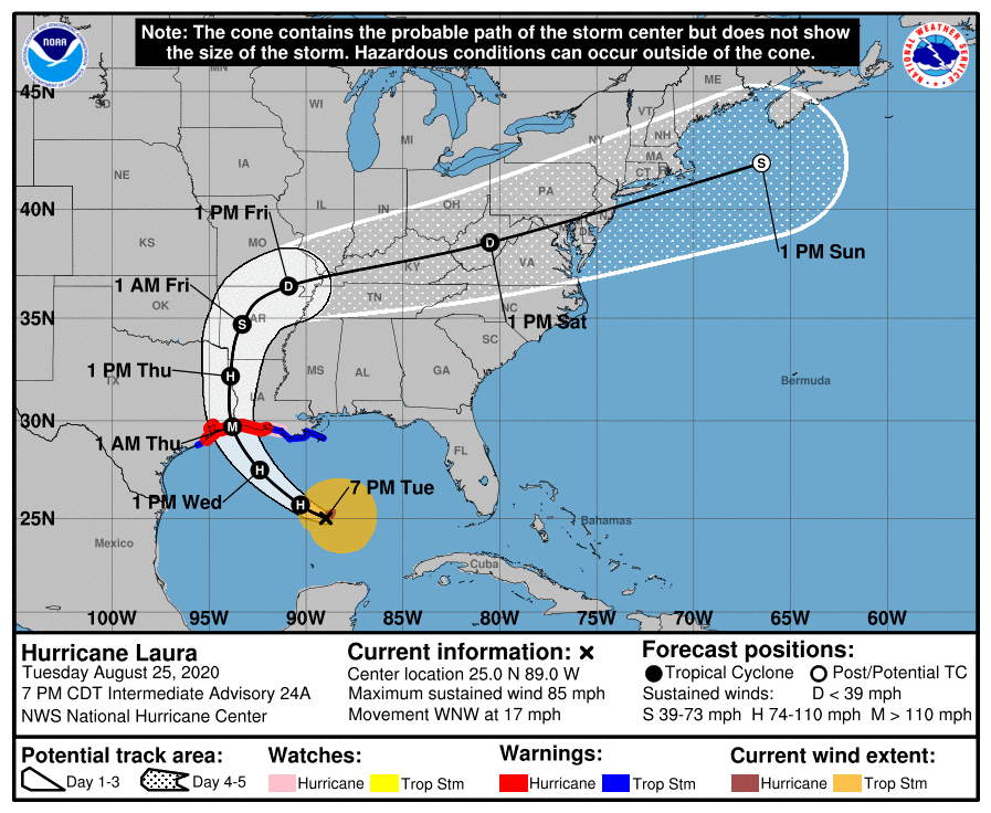
As of the National Hurricane Center’s most recent advisory on Laura at 7:00 PM CDT (00:00 UTC), the center of Hurricane Laura was located near 25.0°N, 89.0°W, about 435 mi (700 km) southeast of Lake Charles, Louisiana, and about 465 mi (745 km) southeast of Galveston, Texas. Maximum sustained winds are near 85 mph (130 km/h) with gusts to 105 mph (165 km/h) and the storm’s minimum central pressure is 983 mb (29.03 inches). Tropical storm-force winds extend outward up to 175 mi (280 km) from the center, and Hurricane-force winds extend outward up to 45 mi (75 km) from the center. Laura is moving toward the west-northwest at around 17 mph (28 km/h), and this general motion should continue overnight. A turn toward the northwest is expected to begin on Wednesday, and a northwestward to north-northwestward motion should continue thereafter. On the NHC’s forecast track, the center of Laura is forecast to move inland near the upper Texas and southwestern Louisiana coasts early Thursday, and continue moving inland thereafter. A northeastward turn should begin on Friday, followed by a generally east-northeastward to eastward motion through the weekend. Laura is forecast to continue strengthening through the next 36 hours, and it is expected to become a Category 3 major hurricane late Wednesday, and maintain that status until landfall. Rapid weakening is expected as Laura moves inland, with it expected to weaken below hurricane status on Friday, and below tropical storm status on Friday. Laura is expected to become a post-tropical cyclone over the weekend as it accelerates rapidly northeastward into the western Atlantic Ocean.
External Links
Please refer to the National Hurricane Center and National Weather Service websites for further information regarding Hurricane Laura as well as watches and warnings in effect. Daily updates and Force Thirteen’s live satellite feed of Hurricane Genevieve can be found on the Force Thirteen YouTube channel at https://www.youtube.com/watch?v=ABfejcNeHK4. Force Thirteen will also be providing live coverage on Laura beginning tonight, and will continue to do so as long as conditions warrant. More information can be found at Force Thirteen’s official outlets, including its Twitter and Facebook pages.
