Super Typhoon Nanmadol to Affect Majority of Japan

Super Typhoon Nanmadol is slowly weakening as it is undergoing an eyewall replacement cycle, but it remains a serious concern for the main Japanese islands. Evacuation orders in Kyushu have been in place, mandating more than a million residents to evacuate as the storm is expected to make serious impacts to Kyushu, Honshu, and Shikoku Islands this weekend and up to the early parts of next week.
Latest Information
The Japan Meteorological Agency (JMA), on its’ 23:00 JST (14:00 UTC) update, has estimated the storm location at 27.7°N 131.8°E or about 315 kilometers (195 miles) south-southeast of Yakushima City, and 450 kilometers (280 miles) south-southeast of Kagoshima City in southern Kyushu. JMA estimates the 10-minute sustained wind to be 195 kph (105 kts / 120 mph), with gusts reaching up to 280 kph (150 kts / 175 mph). The minimum central pressure estimate of the storm was 910 millibars and the storm’s movement was north-northwestward at a speed of 15 kph (8 kt/9 mph).
Latest Advisories in Effect
An Emergency Typhoon Warning is in effect for:
- Southern Kyushu
- Satsuma Region
- Osumi Region
- Tanegashima
- and Yakushima Region.
A Typhoon Warning is in effect for:
- Southern Kyushu
- Miyazaki Southern Plains
- and the Amami Region.
A Gale Advisory is in effect for:
- Okinawa Islands
- Okinawa Main Islands
- Daito Jima Region
- Kume Jima Region
- Rest of the Kyushu Islands including Amami
- Entire Shikoku Island
- Kansai Region (Honshu Island)
- and the Chugoku Region (Honshu Island).
Advisories in Fukuoka and Kumamoto Prefectures are expected to be upgraded to an Emergency Typhoon Warning on Sunday. Kochi Region in Shikoku and the rest of Kyushu Islands except western Oita are expected to be under a Typhoon Warning on Sunday.
For more details in your local area, please refer to your Prefecture Disaster Office or go to JMA website here.
What to Expect?
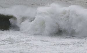
Strong winds, storm surge, and heavy rain are expected to be brought by the Violent Typhoon, as the JMA classifies it. Winds as strong as 195 kph (105 kt / 125 mph) are expected for Southern Kyushu and Amami Islands. Miyazaki Prefecture in western Kyushu is expected to experience winds up to 150 kph (80 kt / 90 mph.) Typhoon conditions are expected in eastern Honshu, and gale-force winds in Chugoku Region in Honshu and the entire Shikoku Island.
Rainfall totals on Sunday in southern Kyushu could reach up to 500 millimeters (20 inches.) In northern Kyushu, totals could still reach 300 millimeters (12 inches) and Shikoku Island up to 150 millimeters (6 inches). This amount of rain could cause widespread flooding, especially to the plains of southern Kyushu. Rivers overflowing are expected as the storm passes.
On Sunday evening, Nanmadol which is still a typhoon will pivot towards the northeast and move towards Honshu, still bringing winds up to 55 kph (30 kts / 35 mph) and rainfall totals up to 100 millimeters (4 inches) enough to inundate some areas in the region.
Heed all orders from your local authorities and get regular updates from the JMA. You can also watch Force Thirteen Automated Streaming Service here:
