Super Typhoon Noru to make Catastrophic Landfall in Northern Philippines

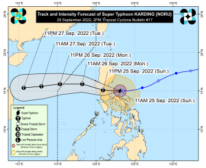
Super Typhoon Noru (PH Name: Karding) is expected to make a destructive landfall in the Northern Philippines. Philippine Atmospheric Geophysical, Astronomical Services Administration (PAGASA) stated in their 2PM PHST (06Z) bulletin, the storm is forecast to make landfall over northern Quezon Province, southern Aurora area tonight. PAGASA is not ruling out a possible landfall over the Polillo Islands in the afternoon.
LATEST INFORMATION
PAGASA’s 2PM (06Z) bulletin estimates the eye of the storm at 15.0°N 122.7°E or about 76 kilometers (47 mi.) east of the Polillo islands, or 115 kilometers (71 mi.) east-northeast of Infanta, Quezon in Mainland Luzon. Noru is packing 10-minute sustained winds of 195 kph (105 kt / 120 mph) with gusts reaching up to 240 kph (130 kt / 150 mph.) The agency also estimates the storm to have minimum central pressure of 920 millibars and is moving westward at a speed of 20 kph (11 kt / 12 mph.)
LATEST WARNING SIGNALS
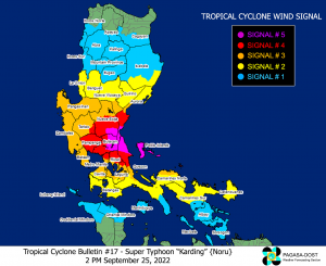
Tropical Cyclone Wind Signal No. 5
Winds of 185 kph or higher, in the next 12 hours since initial issuance
Potential impacts of winds: Extreme threat to life and property
- Polillo Islands
- Extreme Northern Portion of Quezon
- Extreme Southern Portion of Aurora
- Eastern Portion of Bulacan
- Extreme Southeastern Portion of Nueva Ecija
Tropical Cyclone Wind Signal No. 4
Winds of 118 to 184 kph, in the next 12 hours since initial issuance
Potential impacts of winds: Significant to severe threat to life and property
- Calaguas Islands
- Southern Portion of Aurora
- Northern Portion of Quezon
- Northern Portion of Metro Manila
- Central and Southern Portions of Nueva Ecija
- Rest of Bulacan
- Pampanga
- Northern and Central Portions of Rizal
- Southeastern Portion of Tarlac
- Extreme Northern Portion of Laguna
Tropical Cyclone Wind Signal No. 3
Winds of 89 to 117, in the next 18 hours since initial issuance
Potential impacts of winds: Moderate to significant threat to life and property
- Central Portion of Aurora
- Southeastern Portion of Nueva Vizcaya
- Rest of Nueva Ecija
- Tarlac
- Zambales
- Bataan
- Pangasinan
- Rest of Laguna
- Rest of Metro Manila
- Rest of Rizal
- Northern Portion of Laguna
- Northern and Central Portion of Cavite
- Rest of Northern Quezon
- Northern Portion of Camarines Norte
Tropical Cyclone Wind Signal No. 2
Winds of 62 to 88 kph, in the next 24 hours since initial issuance
Potential impacts of winds: Minor to moderate threat to life and property
- Southern Portion of Isabela
- Quirino
- Rest of Nueva Vizcaya
- Benguet
- La Union
- Rest of Aurora
- Rest of Cavite
- Batangas
- Rest of Laguna
- Central Portion of Quezon
- Rest of Camarines Norte
- Northern Portion of Camarines Sur
- Catanduanes
Tropical Cyclone Wind Signal No. 1
Winds of 39 to 61 kph, in the next 36 hours since initial issuance
Potential impacts of winds: Minimal to minor threat to life and property
- Southern Portion of Cagayan
- Rest of Isabela
- Southern Portion of Apayao
- Kalinga
- Abra
- Mountain Province
- Ifugao
- Southern Portion of Ilocos Norte
- Ilocos Sur
- Rest of Quezon
- Northern Mindoro including Lubang Islands
- Marinduque
- Rest of Camarines Sur
- Albay
- Sorsogon
- Burias and Ticao Islands
WHAT TO EXPECT?
TRACK AND INTENSITY: PAGASA forecast a landfall over Southern Quezon – Northern Aurora area at 5PM to 8PM PHST (09Z to 12Z.) An earlier landfall over Polillo Islands is not ruled out. Landfall intensity is forecast to be 185 to 205 kph (10-minute sustained.) After traversing Luzon overnight, it will emerge, still as a typhoon over the coast of Zambales or Pangasinan.
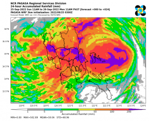
RAIN: On Sunday afternoon through Monday early morning, moderate to heavy rainfall is expected over Central and Southern Luzon including Metro Manila. And from Monday early morning through early afternoon, moderate to heavy rainfall is expected over western Luzon from Pangasinan to Mindoro Island including Metro Manila. With these conditions, flooding and rain-induced landslides are expected. Residents in low-lying areas, next to rivers, and mountains should observe extreme precautions on these hazards.
WINDS: Areas under Warning Signals 4 and 5 will experience typhoon-force winds enough to severely damage infrastructures. Meanwhile, areas under Signal 2 and 3 will experience gale-force winds enough to slightly damage homes. Strong winds may also be experienced in areas under signal 1.
COASTAL INUNDATION: With storm surge forecast to reach 3 meters (10 feet) and heavy rain over coastal areas of northern Quezon including the Polillo Islands and Aurora, the risk of coastal inundation is high to very high. Coastal inundation could also happen in the coastal areas of Central Luzon, rest of Quezon, Pangasinan, and Metro Manila.

naturally like your web-site however you have to take a look at the spelling on quite a few of your posts. Several of them are rife with spelling problems and I find it very bothersome to inform the reality on the other hand I’ll definitely come back again.