Top 10 Storms of 2021

Number 10: Hurricane Rick (EPAC)
Impacted Southern Mexican Pacific States
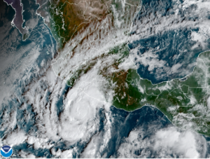
On October 19th, the NHC noted a disturbance formed south of Central America. The disturbance became more organized and was upgraded into a Tropical Depression and designated it as Seventeen-E on the 22nd. And was upgraded by the NHC as a Tropical Storm and named it Rick later that day; into a hurricane the next day and reached its peak as a Category 2 hurricane with winds of 105 mph (165 kph) and pressure of 977 millibars. Shortly after reaching its peak, it made landfall in Mexico east of Lázaro Cárdenas, Michoacán State, Mexico. Rick rapidly weakened as it moved northwards over mountainous terrain and became a remnant low the next day.
Number 9: Gulab-Shaheen (NIO)
Impacted Southern and Western Asia
Noted on September 24 in North Central Bay of Bengal, the disturbance was upgraded as a Depression later that day and was classified as a Cyclonic Storm named Gulab the next day. As it continued westward, the outer rainbands of Cyclone Gulab reached the coastal regions of northern Andhra Pradesh and southern Odisha by the evening of 26th. The JTWC issued its final warning prior to landfall while the IMD downgraded it to a Deep Depression as it traversed India. It was a well-marked low-pressure area as it emerged in the conducive Arabian Sea on the 29. Agencies continued releasing advisories, JTWC upgraded it as a Tropical Storm, still referring to the name Gulab on the 30th. IMD reported that the system had strengthened to a Cyclonic Storm and was named Shaheen. It continued to intensify as it developed an eye; however, it struggled to develop further, due to inadequate convection. On the early morning of October 3, Shaheen made landfall over the northern Oman coast, making it possibly the only cyclone to make landfall there since 1890. Shaheen rapidly weakened after landfall as it moved further inland, weakening into a depression on October 4.
Number 8: Cyclone Tauktae (NIO)
Devastated Western India in May
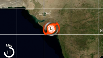
Designated as a Tropical Cyclone 01A in the Arabian Sea on May 14th and named later that day by the IMD as Tauktae. The system continued to intensify and was classified as a Severe Cyclonic Storm the next day, and as a Very Severe Cyclonic Storm by the 16th. It continued to intensify as it brought damaging winds and heavy rain on the coastal states of India facing the Arabian Sea. It slightly weakened before making landfall at night near Diu in Gujarat state and was considered to be the strongest in about two decades. It continued to be a trackable area of low pressure far inland of India. Tauktae left the Western Indian states with considerable damage and left 175 deaths. Neighboring countries of Maldives, Sri Lanka, and Pakistan were also affected by the storm.
Ads by 
Number 7: Major Hurricane Felicia (EPAC)
Strongest Tropical Cyclone in 2021 Eastern Pacific Hurricane Season
A disturbance that was likely from the Central American Gyre was located on July 9th. The system moved westward over the open ocean during the following days slowly organizing and was classified as a Tropical Depression on the 14th and becoming Tropical Storm Felicia later that day. Felicia immediately underwent a rapid intensification, becoming a hurricane on the 15th and a major hurricane the next day. Early on July 17, the system attained peak winds of 145 mph (235 km/h). Surrounded by the dry air of the northeastern Pacific Ocean, Felicia attained annular characteristics. After a brief westward turn, Felicia resumed a west-northwestward motion into much more hostile environmental conditions the 18th and rapidly weakened and degenerated to a remnant low well east of Hawaii two days later.
Number 6: Major Hurricane Grace (NATL)
The first Major Hurricane of 2021 Atlantic Hurricane Season
First noted as an area of interest near Cabo Verde, the system continued to move west-northwestward in the North Atlantic Ocean between Cabo Verde and Leeward Islands. Moving into a more conducive environment with better thunderstorm activity, the National Hurricane Center designated the system as Potential Tropical Cyclone Seven on August 13th. The system continued to intensify and was named Grace the next day. With strong wind shear in the Caribbean Sea, Grace weakened into a Tropical Depression before making landfall on earthquake-hit Haiti. Reemerging in Western Carribean, Grace intensified as a hurricane and made landfall near Tulum, Quintana Roo. Weakened to Tropical Storm, the storm reemerged over Bay of Campeche and rapidly intensified into a Category 3 Major Hurricane less than 48 hours over water. Grace peaked with winds of 125 mph and made landfall in the state of Veracruz. Grace rapidly weakened over rugged terrain of Mexico.
Number 5: Major Hurricane Sam (NATL)
Strongest Tropical Cyclone in 2021 North Atlantic Hurricane Season
Major Hurricane Sam was first noted as a tropical wave coming out of Africa. After days traversing the North Atlantic and fluctuations in thunderstorm activity, the National Hurricane Center upgraded the system as Tropical Depression 18 on September 22th, and was named Sam the next day. Sam intensification was disrupted with dry air intrusion and an eyewall replacement cycle. With Sam’s structure significant improvement and better atmospheric conditions, the storm underwent rapid intensification and peaked on the 26th with winds of155 mph and pressure of 929 mb. Second eyewall replacement cycle caused the storm to weaken on the 27th with Sam growing in size afterwards. The storm regained strength and its Category 4 status. Bermuda was placed under a tropical storm warning on the 30th as the hurricane approached the island experiencing another eyewall replacement cycle and reached a secondary peak. Sam continued to move over the North Atlantic and turned extratropical on October 5th and affected Iceland and Greenland.
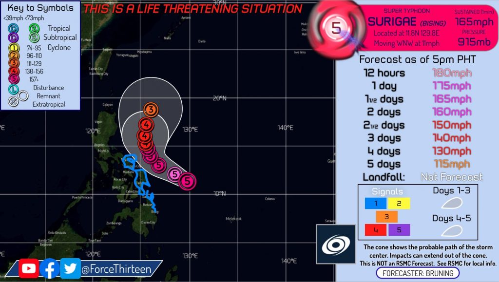
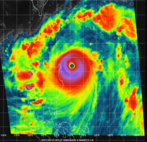
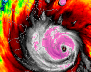
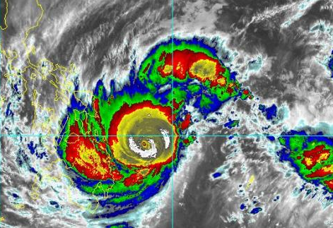
Number 4: Super Typhoon Surigae (WPAC)
Strongest April Tropical Cyclone
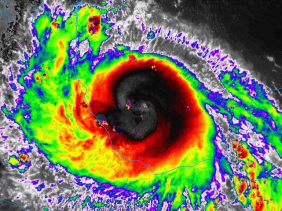
Originated in an area of low pressure south of Guam, the disturbance over part of Western Pacific with low wind shear, warm sea surface temperature, and a good high-level outflow was noted to be conducive to further development. On April 12th, Japan Meteorological Agency (JMA) and Philippine Atmospheric, Geophysical and Astronomical Services Administration (PAGASA) upgraded the disturbance as Tropical Depression; the Joint Typhoon Warning Center (JTWC) followed suit the next day, by then it was named Surigae by JMA. As it slowly moved over the Philippine Sea near Palau, Surigae continued to intensify. With a tight core and conducive environment, Surigae rapidly intensified on the 16th and reached peaks of 10-min winds 220 kph (140 mph) and 1-min winds of 305 kph (190 mph) as per JMA and JTWC, respectively. On the 17th, Surigae experienced an eyewall replacement cycle causing it to weaken. The next day, with diminished outflow and finished eyewall replacement cycle, Surigae acquired annular characteristics. With its slow movement and dry air, Surigae slowly weakened and became extratropical on the 24th.
Number 3: Super Typhoon Chanthu (WPAC)
Impacted Northern Philippines, Taiwan, South Korea, and Japan
On September 5th, an area of interest formed in the Philippine Sea, and JMA classified it as a Tropical Depression the same day. JTWC upgraded it as Tropical Depression the next day, and as a Tropical Storm later that day. JMA named it as Chanthu on September 7th, PAGASA reported the system entered PAR and named Kiko. Chanthu rapidly intensified the same day and became a Category 5 Super Typhoon the next day. Chanthu continued to move northwest and made landfall in Batanes The storm fluctuated in intensity due to multiple eyewall replacement cycles. Chanthu passed east of Taiwan causing heavy rainfall. The system continued to weaken as it reached the East China Sea. The storm slowly moved eastward and made landfall as Tropical Storm in Nagasaki on 17th and weakened into Tropical Depression moving into Japan’s rugged terrain. Chanthu dissipated in the Sea of Japan on the 20th.
Number 2: Major Hurricane Ida (NATL)
Only Major Hurricane Landfall in Continental United States in 2021
Originating as a tropical wave in late August in the southeastern Caribbean Sea, the wave moved westward through the Caribbean. The next day, the system became more organized near Jamaica and was classified as Tropical Depression Nine, later that day Hurricane Hunters found winds of a tropical storm, prompting NHC to name the system Ida. On the 27th, Ida intensified as a hurricane while making two landfalls in Cuba. Ida emerged in the Gulf of Mexico and rapidly intensified over days and became a major hurricane on the 29th. As Ida continued to move towards Louisiana, it further intensified and peaked with winds of 150 mph and pressure of 929 mb. Ida made landfall in Louisiana midday of 29th, tying the 1856 Last island Hurricane and Hurricane Laura as the strongest landfall in the state. The storm sustained Major Hurricane status due to brown ocean effect; and as it moved further inland, Grace rapidly weakened and became an extratropical low. Remnants of the storm caused massive flooding over northeastern United States before dissipating.
Watch the track of Hurricane Ida here: https://www.youtube.com/watch?v=3FnDKCytrbI
Number 1: Super Typhoon Rai (WPAC)
Left Path of Destruction in the Philippines
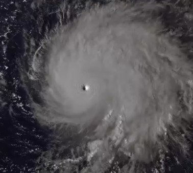
First noted on December 9th south of the Federal States of Micronesia, the disturbance dissipated and was absorbed by another circulation by the 10th. The center of the circulation moved to the convective bursts the next day and was classified as a Tropical Depression on the 13th. The system continued to intensify on the Philippine Sea and was named Rai late into the 13th. Rai continued to organize as it passed north of Palau and was considered a typhoon on the 16th. The storm then rapidly intensified while nearing the Visayas and Mindanao regions. It started an eyewall replacement cycle shortly after reaching peak intensity. Throughout the afternoon of December 16th and 17th, Rai made landfall nine times in the Central part of the Philippines slowly weakening. It then entered the South China Sea and intensified into its second peak due to favorable conditions. Due to the northeast monsoon, Rai rapidly weakened while meandering the coasts of Vietnam and China. Rai left widespread damage and became one of the deadliest and costliest storms in the Philippines.
Read further on the destruction caused to the Philippines here: Typhoon Rai Leaves Path of Destruction Through the Philippines
Article written by Justine, formatted and adapted by Preston Schenk and feature imagery credit to Isaac G.
Rai160 mph 915 mb