Tropical Cyclone Seroja approaching Western Australia; warnings and watches issued

As Tropical Cyclone Seroja approaches Western Australia while absorbing Tropical Cyclone Odette, warnings and watches are being issued in preparation for the storm.
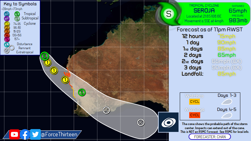
Seroja is currently located at 21.4 degrees south, 108.6 degrees east, approximately 86 nautical miles to the northwest of Learmonth, Australia. The storm currently has maximum 1-minute sustained winds of 65 mph (100 km/h) and a minimum central pressure of 983 millibars, according to Force Thirteen’s analysis. The Joint Typhoon Warning Center currently have Seroja at 70 mph (110 km/h) 1-minute sustained, and a minimum central pressure of 981 millibars.
According to the Regional Specialized Meteorological Centre (RSMC) of the basin, the Bureau of Meteorology (BoM), Seroja is currently a category 2 tropical cyclone in the Australian scale, with 10-minute sustained winds of 65 mph (100 km/h), sustained gusts up to 85 mph (140 km/h), and a minimum central pressure of 976 millibars. It is currently moving south-southeast at 4 mph (6 km/h).
What to expect in the next few days?
Seroja is forecast to continue intensifying under an overall favorable environment, with moderate (15-20 knots) vertical wind shear, robust poleward outflow and warm (27-28°C) sea surface temperatures, while accelerating to the southeast. Force Thirteen is currently forecasting Seroja to peak at 90 mph (150 km/h) in the next 24 hours while commencing an extratropical transition, and make landfall on Western Australia. The transition is expected to finish at 60 hours, when Seroja emerges from Australia and become an extratropical cyclone.
Is there any warnings in effect?
Yes. BoM has issued cyclone watches and warnings on the following areas:
- Warning zone: Cape Cuvier to Geraldton, extending to adjacent inland areas.
- Watch zone: Geraldton to Lancelin and inland areas including Mount Magnet, Paynes Find, Dalwallinu, Merrredin and Southern Cross.
What to experience over Seroja’s passage?
According to the Bureau, “gales with gusts to 100 kilometres per hour are likely to develop in an area between Cape Cuvier and Kalbarri during Sunday afternoon, then extend further south towards Lancelin and inland into the southern Gascoyne and the Central Wheatbelt during Sunday evening and early on Monday morning.”
“Destructive winds with gusts to 150 kilometres per hour are forecast to occur close to the centre of Seroja as it moves across the coast and into adjacent inland parts. The most likely area to experience destructive wind gusts is on the coast between Geraldton and Denham. People near Denham may see gales as early as midday on Sunday, tending to as early as dusk further south near Geraldton. The most likely time for onset of gales winds is mid to late Sunday afternoon near Denham, and during Sunday evening or overnight near Kalbarri and Geraldton.”, the Bureau added.
The Bureau also expects heavy to intense rainfall and flash floodings to occur within Seroja’s track, as well as abnormally high tides that can cause minor inundation at the coast between Coral Bay and Lancelin, increasing to serious flooding in the Denham and Shark Bay region and near Kalbarri.
BoM has also advised people under a yellow alert (in or near Carnarvon to Kalbarri, not including Kalbarri townsite) to take action and get ready to shelter from Seroja, and people under a blue alert (in or near Cape Cuvier to Lancelin, including Cape Cuvier and Lancelin, and extending inland to include the Shires of Northampton, Chapman Valley, Morawa, Greater Geraldton, Mingenew, Three Springs, Perenjori and the townsites of Mullewa, Coorow and Carnamah) to prepare for the upcoming storm.
Please be prepared for this storm, as the storm can trigger flash flooding and kill life. Keep updated with your local officials, and stay safe from this storm. Stay tuned for updates. You can also track Seroja real-time in our Cyclone Tracker: Cyclone Tracker – Force Thirteen (force-13.com)
References:
- The Joint Typhoon Warning Center’s text warning advisory for Seroja: https://www.metoc.navy.mil/jtwc/products/sh2721web.txt
- The Bureau of Meteorology’s Tropical Cyclone Forecast Track Map for Seroja: Tropical Cyclone Forecast Track Map Image – System 1 (bom.gov.au)
- The Bureau of Meteorology’s Tropical Cyclone Technical Bulletin for Seroja: Tropical Cyclone Technical Bulletin 1 (WA) (bom.gov.au)

Seroja will most likely get retired.