Tropical Depression 91B forms in the Bay of Bengal, could become an Extremely Severe Cyclonic Storm

Himawari Imagery of 91B at 02:30 UTC on May 16.
Force Thirteen publicly declared Invest 91B a Tropical Depression today at 02:00 UTC in our first update on the system. While the IMD (India Meteorological Department) and the JTWC (Joint Typhoon Warning Center) have yet to declare 91B a tropical depression, the debate over 91B’s current status may be our least concern at this time.
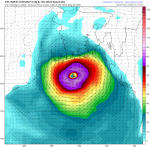
In terms of intensity, several models agree that 91B could become a strong system. On the most recent model run (yesterday at 18z), the GFS has 91B with winds up to 110 mph (175 km/h) and a minimum pressure of 935 millibars, which would be an Very Severe Cyclonic Storm (on the IMD scale), or a high-end Category 2 hurricane (on the Saffir-Simpson scale) in 102 hours. The HWRF model goes even further, putting 91B at 150 mph and minimum pressure of 900 millibars at 102 hours on their 18z run.
Some models are less aggressive with 91B, and the CMC is the least intense major model with a minimum pressure of 961 millibars. However, other major models including the European model are as aggressive as the GFS, taking 91B below 950 millibars. The NAVGEM model also shows 91B’s minimum pressure drop to 936 millibars.
The models are in more disagreement over where 91B is suspected to make landfall. Over the next couple of days, it is expected that 91B will move generally north to northeast. The GFS, NAVGEM, and most models take 91B into the central Bangladesh coastline. However, the European model and the CMC model take 91B into India (albeit, the CMC model’s projected landfall is very close to the Bangladesh border), and the HWRF model takes 91B much closer to Bangladesh’s border with Myanmar. Several other models also take 91B closer and into Myanmar.
All who have interests in the Bay of Bengal (especially those in Bangladesh) should keep a close eye on this system. Force Thirteen has already rated 91B as a Stage 7 out of 10 on the CDPS (Cyclone Potential Destruction Scale), predicting “Catastrophic” damage wherever 91B happens to make landfall, due to the model runs. The next name on the naming list for North Indian Ocean cyclones is Amphan, which is the final name on the original eight lists drafted in 2004 by eight countries for the basin. After Amphan, the North Indian Ocean will move to a new set of thirteen lists for naming tropical cyclones in the North Indian Ocean.
Force Thirteen will continue to release more articles on the progression of 91B here on force-13.com, as well as video updates on our YouTube channel, which can be found by clicking here.
