Tropical Depression forms in the South China Sea, forecast to strike Vietnam; Tropical Disturbance threatens Philippines

The West Pacific never stops, as two systems have formed in the basin.

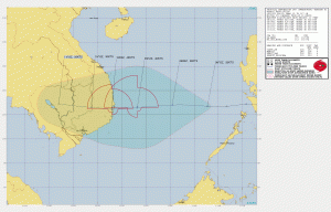
Tropical Depression 24W just formed in the South China Sea, approximately 548 nautical miles to the east-southeast of Da Nang, Vietnam. It has sustained winds of 30mph and a pressure of 1004 millibars. It is expected to intensify to a tropical storm tomorrow before striking Vietnam, and weaken to a tropical depression. This storm formed earlier last week, and affected the Philippines; the Philippine Atmospheric, Geophysical and Astronomical Services Administration (PAGASA), the local agency in the country, has named it as “Tonyo”. There are no warnings in effect for this storm, but if you are from Vietnam, please prepare for this storm.
Meanwhile, east of the Philippines, the PAGASA has named a tropical disturbance east of Mindanao as “Ulysses”. The Joint Typhoon Warning Center has the disturbance as a “high” chance of developing, and has issued a Tropical Cyclone Formation Alert (TCFA) on the system. The storm is currently in a favorable environment of low wind shear, excellent outflow and warm sea temperatures. Models are suggesting the system to organize very quickly while moving north-northwest, before striking Luzon as a strong typhoon and approaching Vietnam in the long run. Stay tuned for updates.
