Tropical Storm 05P forms, may become a strong storm in the next few days; new invest forms north of Niue

The South Pacific is now revving up its activity in early December, as three systems have formed already in the basin.
Tropical Storm 05P (02F) has now formed in the basin, located near 13.7 degrees south, 172.9 degrees east, approximately 413 nautical miles to the northwest of Suva, Fiji. It has maximum sustained winds of 40 mph (65 km/h) with gusts of 50 mph (85 km/h), and a minimum pressure of 1000 millibars. The storm is currently moving south-southeastward at 15 knots (15 mph; 30 km/h) and is currently absorbing the remnants of Tropical Storm 04P, which is designated as 01F by the Regional Specialized Meteorological Centre of the basin, the Fiji Meteorological Service. The Joint Typhoon Warning Center is forecasting 05P to intensify into 125 mph (205 km/h) on their 120 hour forecast, but it is noted that the centre has low confidence for their forecast as of now.
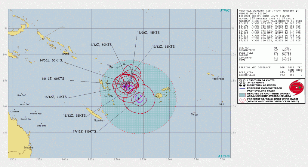
The storm is enveloped within high uncertainty due to the system absorbing 04P. The FMS is also forecasting a category 4 cyclone in the Australian scale in three days in the basin.
Meanwhile, an invest was also designated in the basin. Invest 92P is located at 14 degrees south, 170.3 degrees west, to the north of Niue, with winds of 15 mph (30 km/h) with a pressure of 1010 millibars. Models are hinting of development from this storm, as it moves towards the southeast.
The next names for the South Pacific is Yasa, followed by Zazu. Stay tuned for updates.
