Tropical Storm Barbara Forms in the Eastern Pacific; Could Become a Potent Hurricane

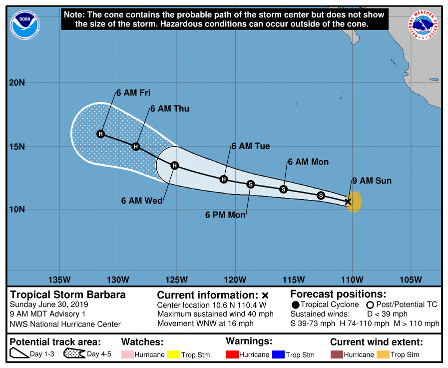
At 9:00 AM MDT (15:00 UTC), the National Hurricane Center classified Invest 94E, a tropical disturbance which had been showing signs of organization during the past few days, as Tropical Storm Barbara, the second named storm of the 2019 Eastern North Pacific hurricane season. As of the National Hurricane Center’s most recent advisory, the center of Tropical Storm Barbara was located at 10.6°N, 110.4°W, about 850 mi (1370 km) south of the southern tip of the Baja California Peninsula. Barbara had maximum sustained winds of 40 mph (65 km/h), with gusts to 50 mph (85 km/h), and the minimum central pressure was 1006 mb (29.71 inches). The cyclone was moving west-northwestward at 16 mph (26 km/h), and this motion is expected to continue over the next several days, albeit with a gradual decrease in forward speed. The NHC forecasts slow, but steady strengthening over the next couple of days, followed by quicker intensification into a Category 2 hurricane, and then gradual weakening afterward. Barbara will likely enter the Central North Pacific basin late next week, at which time the Central Pacific Hurricane Center (CPHC) will take the responsibility of warning on the system. Barbara is a rather broad tropical cyclone at this time, though tropical storm-force winds only extend 80 miles (130 km) eastward from the center. There are no tropical cyclone watches or warnings in effect at this time, and Barbara is not expected to affect land at this time.
Track and Intensity Guidance
The general consensus among computer models is that Barbara will take a generally westward to west-northwestward track during the next few days and gradually decelerate as it approaches the southern edge of a mid-level ridge. The majority of models show steady intensification into a hurricane, and as the cyclone will remain over warm waters and in a favorable atmospheric environment for the next four to five days, such intensification is very likely. In fact, conditions will be favorable for rapid intensification, and Barbara has the potential to strengthen into a major hurricane if the cyclone consolidates. With these prolonged favorable conditions in mind, the NHC’s forecast lies on the high end of the model guidance, and shows Barbara intensifying into a Category 2 hurricane.
Some models show Barbara passing close to or making landfall in the Hawaiian islands at the end of their forecasts. While it is too soon to determine what, if any, impacts Barbara may bring to the islands, residents in this area should closely monitor Barbara and have a tropical cyclone plan prepared in the event that Barbara does affect the islands.
You can follow the progress of Tropical Storm Barbara through Force Thirteen’s official outlets. Live updates on Barbara can be found at the official Force Thirteen YouTube channel, and further information can be found on the Force Thirteen Twitter and Facebook pages.
