Tropical Storm Barry Forms in the Gulf of Mexico; Dangerous Storm Surge, Strong Winds, and Heavy Rainfall Expected Across the U.S Gulf Coast

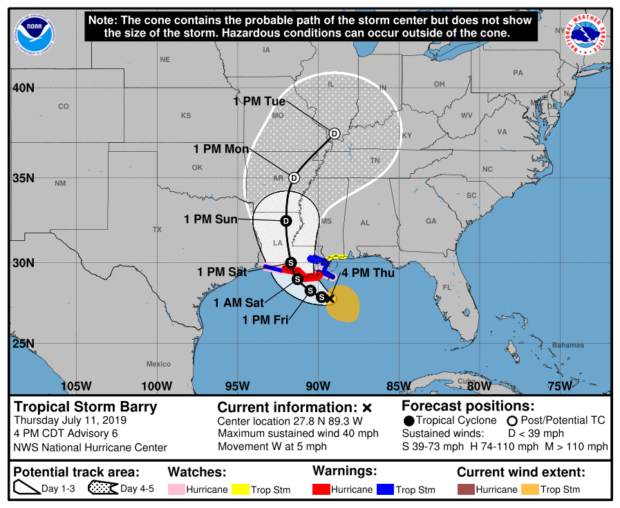
The low pressure area over the northern Gulf of Mexico, marked as Potential Tropical Cyclone Two by the National Hurricane Center (NHC), has continued to become better organized today. The United States Air Force and the NOAA have been conducting reconnaissance flights into the system, and they have recently reported sustained winds of gale-force within the developing cyclone. Based on these recent observations, the NHC classified the disturbance as Tropical Storm Barry at 10:00 AM CDT (15:00 UTC). As of the most recent advisory from the Hurricane Center at 7:00 PM CDT (00:00 UTC) July 12, the center of Tropical Storm Barry was located near 27.8°N, 89.3°W, about 90 mi (145 km) south of the Mississippi River, or about 175 mi (280 km) southeast of Morgan City, Louisiana. Barry had maximum sustained winds of 45 mph (75 km/h), with gusts to 50 mph (85 km/h), and the minimum central pressure was 1003 mb (29.62 inches). The cyclone was moving westward at 3 mph (5 km/h), and this westward motion is forecast to continue tonight. On Friday, Barry is forecast to turn toward the northwest, and then to the north by Saturday, at which time it will likely be moving inland into the lower Mississippi Valley. Barry is a relatively large tropical cyclone, with Tropical storm-force winds extending outward up to 140 miles (220 km) from the center. The NHC anticipates strengthening during the next two days, and Barry could become a hurricane before it makes landfall on the Louisiana coast.
Track and Intensity Guidance
Model guidance with Barry has not been very consistent during the past few days, although recently the track guidance has been shifting eastward. Most models show the cyclone making landfall on the central Louisiana coast, although there are a few outliers, such as the UKMET and UKMET ensemble, which take the cyclone into the upper Texas coast, and the HWRF and HMON, which show the storm moving across southeastern Louisiana. All are in unanimous agreement that the cyclone will make landfall somewhere on the Gulf Coast of the United States late Friday or on Saturday, and then recurve northeastward as it encounters the mid-latitude westerlies. By that time, the cyclone is likely to be a tropical depression or post-tropical cyclone. The NHC forecast cone lies in the middle of the extremes and is in agreement with the GFS (American), ECMWF (European), and CMC (Canadian) models, showing Barry making landfall on the central Louisiana coast on Saturday, and then weakening as it moves inland, becoming post-tropical over eastern Arkansas on Monday.
The intensity guidance has been on a downward trend today. Earlier today, many models showed Barry strengthening into a Category 1 hurricane. However, only a small number now show such intensification. The ECMWF ensemble members show more intensification than those of the GEFS, few of whose members show the system becoming a hurricane. The cyclone is currently being affected by northerly shear and dry mid to upper-level air, although this has not stopped development thus far, and most of the guidance does show at least some intensification. However, the structure of the cyclone currently remains broad, which may serve as an inhibiting factor toward intensification. The NHC forecast is in agreement with the guidance, and calls for intensification into a strong tropical storm. Although not explicitly shown in the forecast, the center noted that “there is a significant chance that Barry will be a hurricane when it makes landfall between 36-48 h (on the forecast track) in agreement with the HWRF and GFS models”. After landfall, Barry is forecast to weaken as it moves through the Mississippi Valley, and it is expected to become a post-tropical cyclone or remnant low by Monday. Regardless of Barry’s future intensity, the cyclone is expected to bring life-threatening storm surge inundation, heavy rainfall, and wind damage to much of the north-central Gulf Coast.
Impacts and Areas at Risk
Although it is still unknown exactly where Barry will make landfall, the cyclone is expected to bring impacts to much of the north-central Gulf Coast. Heavy rainfall and dangerous surf conditions are expected from the upper Texas coast eastward to the Florida panhandle. The most significant impacts are expected in areas near the central Louisiana coast, where the center of Barry is currently forecast to make landfall. A Hurricane warning is in effect for the coast of Louisiana from Intracoastal City to Grand Isle, while a Hurricane watch is in effect from the mouth of the Mississippi River to Grand Isle, and from Intracoastal City to Cameron. Tropical Storm warnings are also in effect for these areas, as well as for Lake Pontchartrain and Lake Maurepas, and includes the New Orleans metropolitan area. Tropical storm watches are in effect from east of the mouth of the Pearl River to the Mississippi/Alabama border. Storm Surge warnings are in effect from the Mouth of the Atchafalaya River to Shell Beach, while Storm Surge watches are in effect from Shell Beach to the Misssippi/Alabama border, Lake Pontchartrain, and from the mouth of the Atchafalaya River to Intracoastal City. Further inland, heavy rainfall is expected in much of the Southern and Midwestern United States as Barry moves inland. A more detailed analysis of the threats at hand is presented below.
Rainfall
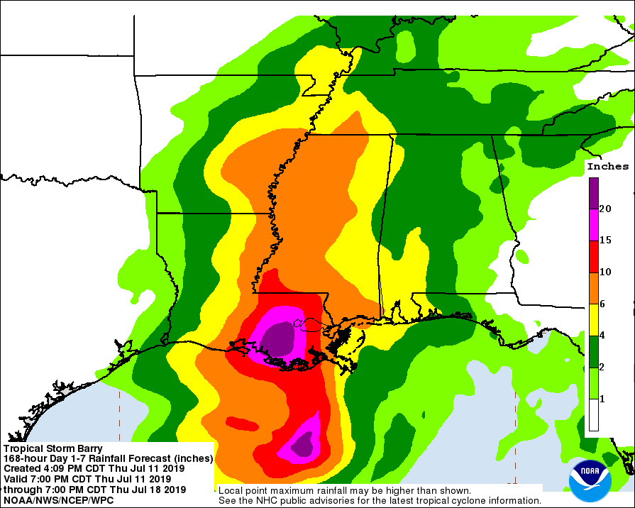
Barry is expected to produce extremely heavy rainfall across much of the Mississippi Valley due to its anticipated slow movement across the region. Total rain accumulations of 10 to 20 inches (254 to 508 mm) are expected over southeastern Louisiana and southwestern Mississippi, with localized amounts of up to 25 inches (635 mm) possible. Over the remainder of the Mississippi Valley, rainfall amounts of 4 to 8 inches (102 to 203 mm) are forecast, with localized amounts of up to 12 inches (305 mm) possible. Lighter rainfall amounts are forecast from eastern Texas into Alabama and the Florida panhandle, as well as in the Midwestern United States. Heavy rainfall can cause life-threatening flash floods, especially in low-lying and coastal areas. Flooding of lakes, rivers, and other bodies of freshwater is likely. Flooding induced by heavy rainfall is one of the most significant threats associated with tropical cyclones. Rapidly-rising flood waters can quickly inundate roadways and areas of poor drainage. Some rivers, creeks, and streams may overflow their banks, which can inundate nearby structures. When faced with a flooded roadway, do not attempt to drive or walk through. Water can easily sweep you or your vehicle away, you may be swept downstream and risk drowning. If flash flooding is occurring, move to higher ground and stay away from the flooded area.
Storm Surge
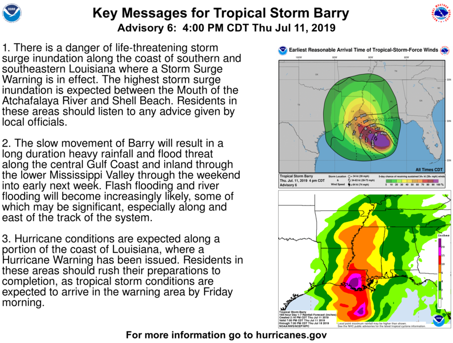
Dangerous storm surge is expected in association with Barry along much of the Louisiana and Mississippi coasts. The combination of a dangerous storm surge and enhanced tide can cause normally dry areas along the coast to become flooded by the rising waters moving inland from the shore. If the peak storm surge occurs at high tide, the water could reach heights of 2 to 6 feet (0.6 to 1.8 m) in the warned area, with the highest surge expected from the mouth of the Atchafalaya River to Shell Beach. Storm surge is often the greatest threat to life and property to areas along the coastline. Storm surge can cause severe beach erosion and can cause significant damage to structures near the coast from wave action and rapidly-rising seawater. If you live in a coastal area threatened by storm surge, follow evacuation orders and take precautions to ensure the safety of yourself and others. Assemble disaster supplies and plan your evacuation route ahead of time.
Wind
Barry is expected to produce Hurricane conditions along the central and eastern Louisiana coast, and Tropical Storm Conditions from the western coast of the state to the Mississippi coast. Tropical Storm conditions are expected to arrive in the warning area late tonight and Friday morning, and are possible in the watch area by Friday night and Saturday. Hurricane conditions are expected in the warning area and are possible in the watch area at that time as Barry closes in on the coast. Hurricane-force winds in excess of 75 mph (120 km/h) with higher gusts can cause damage to buildings and cause trees and power lines to fall. Loose objects may be picked up by the winds and be turned into projectiles. If Hurricane conditions are imminent or occurring, move into an interior room or on the lowest floor of a building. Stay away from windows, which may be shattered by objects blown by the winds. Offshore, seas will become very rough as hurricane conditions arrive. Mariners are advised not to venture out into the waters in Hurricane and Tropical Storm conditions. In addition to these strong winds, a few tornadoes are possible Friday morning through Friday night across southeast Lousiana, southern Mississippi, and the Alabama coast.
Residents in the north-central Gulf Coast area should closely monitor the progress of Barry. Take proper measures to prepare for the storm, and evacuate if advised to do so. Ensure that friends, family, and neighbors are prepared as well. Being properly prepared can mean the difference between life and death in the event of a tropical cyclone impact.
External Links
Please refer to the National Hurricane Center and National Weather Service websites for further information regarding Tropical Storm Barry as well as watches and warnings in effect. Force Thirteen will be providing daily coverage on Tropical Storm Barry. Live updates and Tropical Weather Bulletins can be found at the Force Thirteen YouTube channel. More information can be found at Force Thirteen’s Twitter and Facebook pages.
