Tropical Storm Bavi Expected to Strengthen Significantly on Approach to the Korean Peninsula

Earlier today, the low pressure system which the Joint Typhoon Warning Center (JTWC) and East Asian regional meteorological offices have been monitoring for the past couple of days, was designated as Tropical Storm Bavi, the eighth named storm of the 2020 Northwestern Pacific typhoon season. Since then, Bavi has been on a nearly continuous strengthening trend, although this seems to have paused recently. Nevertheless, Bavi is forecast to strengthen significantly over the next few days as it moves slowly northwestward. By early next week, the cyclone is expected to accelerate northward, and could impact the western Japanese islands and the Korean Peninsula as a potentially significant typhoon.
Tropical Storm Bavi: Current Storm Information
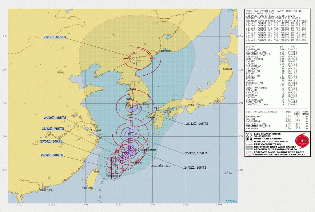
As of the most recent bulletin from the Joint Typhoon Warning Center at 15:00 UTC (00:00 JST), the center of Tropical Storm Bavi (09W) was located near 25.3°N, 123.8°E, about 200 km (125 mi) east-northeast of Taipei, Taiwan. Maximum 1-minute sustained winds are near 95 km/h (60 mph), with gusts to 120 km/h (75 mph), and maximum 10-minute sustained winds are near 100 km/h (60 mph). The minimum central pressure is 990 mb (29.23 inches), and tropical storm-force winds extend outward up to 185 km (115 mi) from the center. Bavi is moving toward the west-northwest at around 21 km/h (13 mph), and this general motion is expected to continue through tonight. Afterward, a gradual turn to the north is expected through Monday, with an increase in forward speed beginning shortly afterward. On the JTWC forecast track, the center of Bavi will pass just to the east of Jeju, South Korea, on Wednesday, and move inland over the Korean Peninsula shortly afterward. Strengthening is expected over the next few days as Bavi remains in a quite favorable environment for intensification, and it is forecast to attain typhoon status on Sunday. Further strengthening is expected thereafter, and Bavi is forecast to become a Category 3-equivalent (on the Saffir-Simpson scale) typhoon by Tuesday. Some weakening is then anticipated before Bavi reaches the Korean Peninsula, with rapid weakening anticipated thereafter as the system moves inland.
Forecast Track, Intensity Guidance, and Hazards Affecting Land
Bavi is expected to become a potent typhoon over the East China Sea by early next week, and this is reflected by nearly all the dynamical guidance and the global models + ensembles. Although there is still uncertainty in exactly where Bavi will make landfall, and it is too soon to determine the magnitude of impacts, interests in the southwestern Japanese islands, Korean Peninsula, and northeastern China should closely monitor the progress of Bavi. Further, and possibly significant, adjustments in the track and intensity forecast for Bavi are possible during the next few days, and users should closely monitor this situation for further updates.
Please refer to to your local meteorological office for further information regarding Tropical Storm Bavi as well as watches and warnings in effect. Daily updates on Tropical Storm Bavi can be found on the Force Thirteen YouTube channel. More information can be found at Force Thirteen’s official outlets, including its Twitter and Facebook pages.
