Tropical Storm Bertha Forms off the Carolina Coast; Heavy Rainfall Expected Across the Carolinas and Southern Virginia

The area of low pressure which the National Hurricane Center (NHC) has been monitoring over the past day or so has quickly become better organized this morning, and is now Tropical Storm Bertha. This is the second named storm of the 2020 Atlantic hurricane season, and marks only the sixth occurrence of multiple tropical cyclones before the official start of the Atlantic hurricane season on June 1. As of the most recent advisory from the National Hurricane Center (NHC) at 11:00 AM EDT (15:00 UTC), the center of Tropical Storm Bertha was located near 33.3°N, 79.5°W, about 40 mi (65 km) northeast of Charleston, South Carolina. Maximum sustained winds are near 50 mph (65 km/h) with gusts to 65 mph (100 km/h), and the minimum central pressure is 1005 mb (29.68 inches). The cyclone is moving northward at around 15 mph (24 km/h), and this general motion is expected to continue through tonight with a gradual increase in forward speed. On the NHC’s forecast track, Bertha will be moving inland across South Carolina today and into North Carolina by tonight. Bertha is expected to weaken to a tropical depression later today and become a remnant low overnight.
Forecast Track, Intensity Guidance, and Hazards Affecting Land
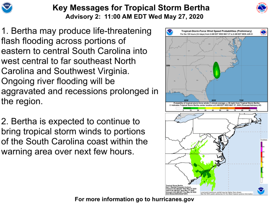
Bertha is already making its way onto the coast of South Carolina, and is expected to be a short-lived tropical cyclone as it continues inland. The system is expected to weaken as it continues inland, and is expected to become a remnant low by late Thursday or early Friday while it is located over western Virginia and southern West Virginia. However, Bertha is expected to continue to produce tropical storm-force winds across portions of the South Carolina coast within the next few hours. Heavy rainfall is expected across portions of eastern and central South Carolina, western and central North Carolina, and southwestern Virginia through Thursday, which may produce life-threatening flash flooding and exacerbate ongoing river and freshwater flooding. Total rainfall accumulations of 2 to 4 inches (51 to 102 mm) with isolated totals up to 8 inches (203 mm) are forecast across the aforementioned areas. Flooding is one of the leading causes of damage and deaths from tropical cyclones. Never attempt to walk or drive into a flooded area, the water may be much deeper than it appears. If flash flooding is occurring, move to higher ground and stay away from the flooded area. Ensure that you have taken proper precautionary measures and have an emergency plan in action in case basic utilities become inaccessible.
External Links
Please refer to the National Hurricane Center and National Weather Service websites for further information regarding Tropical Storm Bertha as well as watches and warnings in effect. Force Thirteen will be providing live coverage on Tropical Storm Bertha this morning, and will continue to provide updates as conditions warrant. More information can be found at Force Thirteen’s official outlets, including its Twitter and Facebook pages.
