Tropical Storm Chalane moves closer to Africa; Mozambique president urges people to evacuate

After moving through Madagascar, Tropical Storm Chalane has begun re-intensifying in the Mozambique Channel, and officials in both Mozambique and Zimbabwe have begun preparations.
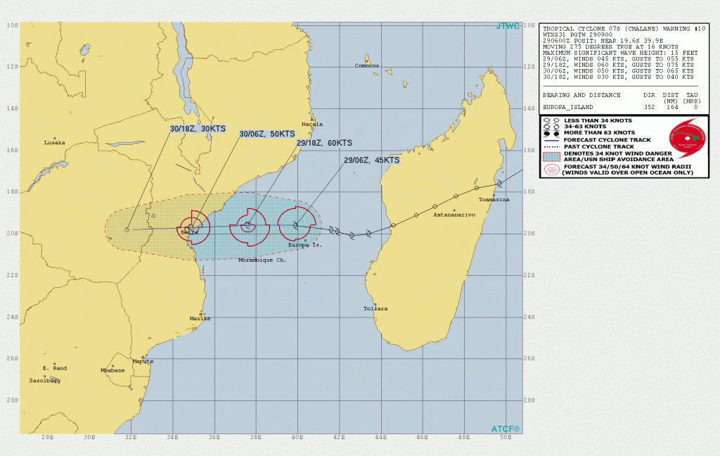
Tropical Storm Chalane is located near 19.6 degrees south, 39.9 degrees east, approximately 157 nautical miles to the north of Europa Island. The storm has 1-minute sustained winds of 50 mph (85 km/h), with gusts up to 65 mph (100 km/h), and a minimum central pressure of 995 millibars. The Regional Specialized Meteorological Centre of the southwest Indian Ocean basin, the Meteo-France, has Chalane at severe tropical storm status, with 10-minute winds of 60 mph (95 mph), and a central pressure of 990 millibars. The storm is currently moving westwards at 16 knots (18 mph; 30 km/h), and further intensification is forecast until its landfall near the capital city of Mozambique, Beira.
Meteo-France is forecasting Chalane to become a tropical cyclone (hurricane-equivalent) storm in 12 hours, then later weaken as it moves to land. In preparation for this storm, officials in Mozambique are now pre-positioning teams and resources in Sofala, Manica, Inhambane and Zambezia provinces. The president of Mozambique, Filipe Nyusi warned on 27 December, in a post on Facebook, that the tropical storm could affect four million Mozambicans in the central provinces as the warmth of the surface waters in the Mozambique Channel is predicted to strengthen the storm. He urged people living in at-risk areas to evacuate, since the storm is likely to bring floods.
Meanwhile, in Zimbabwe, the Directorate of Civil Protection is leading preparedness and convened a follow-up meeting with humanitarian partners to discuss necessary actions. The government has indicated that people displaced by Cyclone Idai of 2019 who are still living in four camps in Chimanimani will be moved to safe centres at St Patrick’s High School and Nyanyadzi Training Centre.
Please stay safe for this storm, as the Meteo-France noted that in the Beira region, destructive gusts (exceeding 150 km/h) are possible at less than 60 kilometers from the center, since Chalane is rather a compact cyclone. In terms of precipitation, the center noted that “accumulations of more than 100 mm [millimeters] in 24 hours are possible. These rains, which can cause flash floods and floods, will spread far inland over Zimbabwe on 31 December and Botswana on 01 January”. Storm surge of about 2 meters is possible near and just south of where Chalane is forecast to hit, coupled with storm swell and high water (in line with the timing of the landfall on the current forecast), this surge will be associated with coastal floodings.
Stay tuned for updates. You can also track Chalane real-time at our Cyclone Tracker here: Cyclone Tracker – Force Thirteen (force-13.com)
References:
- The Joint Typhoon Warning Center’s text advisory on Chalane: https://www.metoc.navy.mil/jtwc/products/sh0721web.txt
- The Joint Typhoon Warning Center’s forecast cone on Chalane: sh0721.gif (1672×1058) (navy.mil)
- The Meteo-France’s English advisory on Chalane: CMRSA_202012290600_CHALANE.pdf (meteo.fr)
- The United Nations’ Office for the Coordination of Humanitarian Affairs’ Flash Update on Chalane: Southern Africa, Flash Update No.3: Tropical Storm Chalane (as of 28 December 2020) – Madagascar | ReliefWeb
