Tropical Storm Chantal forms far over the North Atlantic; Invest 95E Likely to Develop into a Tropical Cyclone

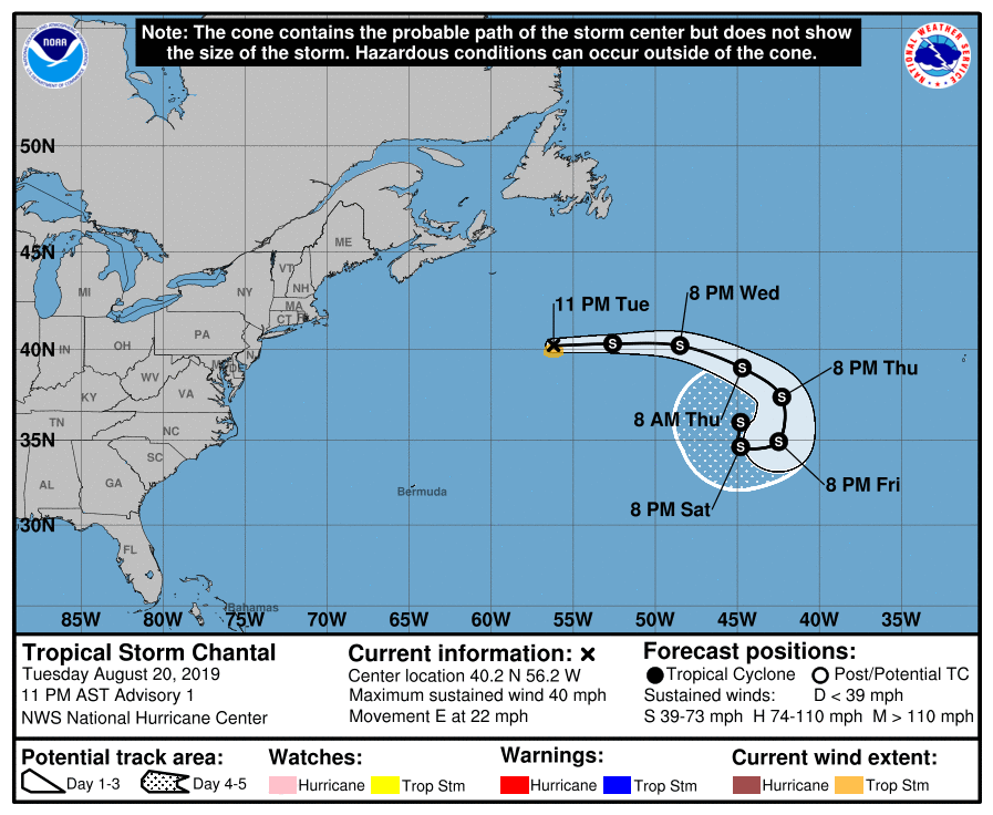
After a lengthy period of inactivity lasting 28 days, the North Atlantic Ocean has finally sprung into action with the formation of Tropical Storm Chantal this morning. Although environmental conditions were not forecast to favor development, a small low pressure system located over the far northern Atlantic Ocean which the National Hurricane Center (NHC) had been monitoring during the past few days acquired a well-defined surface circulation today. As the low was already producing tropical storm-force winds, the NHC classified the system as a tropical storm at 03:00 UTC. As of that first advisory, the center of Tropical Storm Chantal was located near 40.2°N, 56.2°W, about 485 mi (780 km) southeast of Halifax, Nova Scotia, or about 475 mi (765 km) south-southwest of Cape Race, Newfoundland. Maximum sustained winds were 40 mph (65 km/h), gusting to 50 mph (85 km/h), and the minimum central pressure was 1010 mb (29.83 inches). Chantal is moving quickly eastward at around 22 mph (35 km/h), and this motion is forecast to continue through Friday, though with a decrease in forward speed. Tropical storm-force winds extend outward up to 45 miles (75 km), though mainly to the south of the center.
During the next 48 hours, Chantal is expected to be under the effects of moderate southwesterly to westerly shear as it moves generally eastward and gradually slows down. After that time, however, this shear is forecast to weaken significantly, and by that time Chantal should be moving southward around the eastern portion of the Bermuda-Azores high, which is prompting the storm’s easterly motion. This southerly motion will bring Chantal over warmer waters with sea surface temperatures (SSTs) of near 27°C (80.6°F). While this could allow for intensification, an abudance of dry air in this area will likely limit strengthening. Thus, the NHC forecast calls for no change in intensity during the next five days, and notes that the dry environment could cause the cyclone to dissipate sooner than forecast.
Renewed Activity in the Eastern Pacific
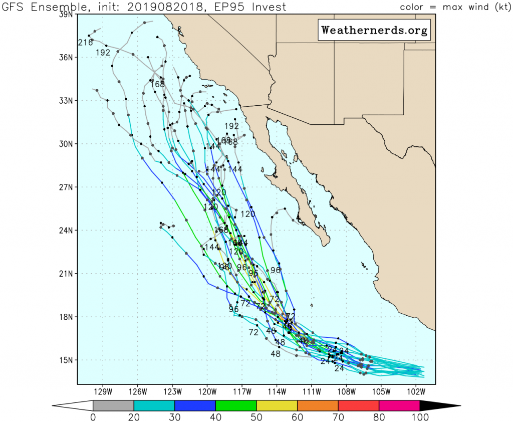
A broad area of low pressure located off the southern coast of Mexico is producing a large area of showers and thunderstorms across much of the eastern Pacific waters. This system, which has been designated as Invest 95L by the United States Navy, has recently been showing some signs of organization. As environmental conditions are expected to be favorable for further development, the NHC has given this system a high (90%) chance of becoming a tropical cyclone during the next 48 hours, and a high (90%) chance of becoming a tropical cyclone during the next five days, stating that a tropical depression is likely to form during the next 24 hours or so as the system moves west-northwestward, parallel to the coast of Mexico. Most models are in good agreement that Invest 95E will develop into a tropical cyclone within the next 48 hours, and are also in agreement on a general track. Most show a generally west-northwestward track during the next two to three days, after which time it should acquire a more northwesterly motion parallel to the Baja California Peninsula. The GFS (American) ensembles show the system turning northward sooner and show more intensification than the ECMWF (European) ensembles do. Although it is forecast to remain offshore, this large system could produce locally heavy rainfall along the coast of southern Mexico during the next day or two, and could later produce large swells off the coast of Baja California by the end of the week.
Another area of low pressure, labeled invest 97E by the United States Navy, located well over the open waters of the Eastern Pacific, is also being monitored for tropical cyclone formation. However, this system has become less organized and conditions are becoming less conducive for tropical cyclone formation. This system currently has a low (20%) chance of tropical cyclone formation during the next 48 hours, and a medium (40%) chance of tropical cyclone formation during the next five days.
For more information regarding current activity in the tropics, visit Force Thirteen’s official outlets. Live updates and daily Tropical Weather Bulletins can be found at the official Force Thirteen YouTube channel, and further information can be found on the Force Thirteen Twitter and Facebook pages.
