Tropical Storm Cristobal Continues to Lash Southern Mexico

Tropical Storm Cristobal, now currently a tropical storm with winds of 50 mph and a central pressure of 996 mbar, came ashore earlier today and has begun to weaken, but still poses a significant flooding threat throughout portions of southern Mexico and central America over the next several days.
Earlier today, Tropical Storm Cristobal made landfall just west of Ciudad del Carmen at around 13:35 UTC. At this time, Cristobal was producing maximum sustained winds of around 60 mph and a minimum central pressure of 994 mbar, making it a moderately strong tropical storm. Since then, Cristobal has weakened slightly as it continues to move inland, although radar estimates have already suggested that isolated totals of up to 26 inches of rain have already fallen near the landfall area in Campeche.
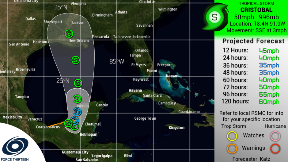
The future of Cristobal remains moderately uncertain, as it is currently interacting with the larger gyre, which is pulling it generally southeastward and further inland. The gyre is expected to weaken over the coming days, and Cristobal is expected to slowly turn north again and reemerge over the waters of the Gulf of Mexico on Friday. It is expected to weaken to a depression on Thursday, although conditions are expected to be favorable for restrengthening once it reemerges over water on Friday, and Cristobal could ultimately impact the Gulf Coast as a tropical storm early next week.
Cristobal remains a dangerous system despite not being particularly intense due to its slow movement over land. The slow movement will allow Cristobal to produce very heavy rainfall over portions of southern Mexico and into Central America. Totals of 10-20 inches are expected through several states in southern Mexico, with similar totals possible in southern Guatemala. El Salvador is expected to receive an additional 10-15 inches of rain, while totals of 3-6 inches are expected over Belize and Honduras. Gusty winds may accompany the rain, but heavy rainfall, flash flooding and mudslides are expected to remain the main threat.
For the latest official information, please refer to the National Hurricane Center.
Force Thirteen also produces regular updates on their Twitter page and YouTube channel.
