Tropical Storm Dalila Forms in the Eastern Pacific; Tropical Depression Three Dissipates off the Florida Coast

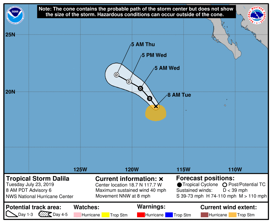
Tropical Depression Five-E formed yesterday over the open waters of the Eastern Pacific Ocean. After initially struggling to become better organized, the depression’s circulation became better defined this morning, and the National Hurricane Center (NHC) upgraded the cyclone to Tropical Storm Dalila at 2:00 AM PDT (09:00 UTC). As of the most recent advisory at 8:00 AM PDT (15:00 UTC), the center of Tropical Storm Dalila was located near 18.7°N, 117.7°W, about 580 mi (935 km) west-southwest of the southern tip of the Baja California Peninsula. Maximum sustained winds were 40 mph (65 km/h), gusting to 50 mph (85 km/h), and the minimum central pressure was 1006 mb (29.71 inches). The cyclone was moving north-northwest at 8 mph (13 km/h), and it is expected to turn northwest tonight, and then west-northwestward on Thursday. Tropical storm-force winds extend outward up to 90 miles (150 km) from the center of the cyclone. Dalila is already approaching cooler ocean waters, and moderately strong northerly wind shear continues to affect the cyclone. For these reasons, the NHC expects that the cyclone will begin to weaken today, and degenerate into a remnant low by Wednesday.
Tropical Depression Three dissipated this morning just as quickly as it formed. An Air Force reconnaissance aircraft investigating the system this morning found light southwesterly winds and no evidence that a surface circulation existed. As a result, the NHC issued their last advisory on the system at 11:00 AM EDT (15:00 UTC), determining that the depression had degenerated into a trough of low pressure. As of the NHC’s final advisory, the Remnants of Three were located near 29.0°N, 80.0°W, about 60 mi (100 km) east-southeast of Daytona Beach, Florida, or about 100 mi (160 km) southeast of St. Augustine, Florida. Maximum sustained winds were 35 mph (55 km/h), gusting to 45 mph (75 km/h), and the minimum central pressure was 1014 mb (29.95 inches). The remnants were moving toward the north at 17 mph (28 km/h), and they are expected to turn north-northeast today and become embedded within a cold front located over the southeastern United States.
Elsewhere, the tropics remain quiet for the time of year. Invest 96S, located over the Southwestern Indian Ocean, has a low chance of developing into a tropical cyclone during the next few days. Another system, Invest 91W, which is located southwest of the Ryukyu Islands, also has a low chance of tropical cyclone formation during the next few days. A tropical wave located over the Eastern Pacific is also being monitored by the NHC for potential development over the next few days.
For more information regarding current activity in the tropics, visit Force Thirteen’s official outlets. Live updates and daily Tropical Weather Bulletins can be found at the official Force Thirteen YouTube channel, and further information can be found on the Force Thirteen Twitter and Facebook pages.
