Tropical Storm Danny Forms off the Coast of South Carolina

Radar image of Tropical Strorm Danny at 1937z on June 28 (image vai Radarscope
Radar image of Tropical Storm Danny at 1937z on June 28 (image via Radarscope)
The National Hurricane Center, as of their 3:05 pm Eastern Daylight Time special update (1905 z update) observed winds off of the Charleston, South Carolina radar that indicated, that Tropical Depression Four had organized enough and had sufficient winds to upgrade Tropical Depression Four to Tropical Storm status and give the name Danny to this tropical system.
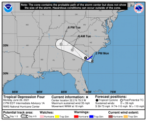
As of the special update, Tropical Storm Danny is currently located at 32.2º N , 79.7ºW or roughly 55 miles (90 Kilometers) south of Charleston, South Carolina. With Danny moving Northwest at 16 Miles Per Hour (26 Kilometers per hour) and currently moving towards a landfall with maximum sustained winds of 40 miles per hour (65 kilometers per hour). Given its current movement speed, landfall will most likely occur in the next six hours. bringing upwards of one to eight inches of rain across South Carolina, Georgia, Alabama and into Tennessee over the next five days
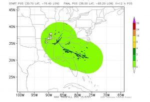
The current forecast for Tropical Storm Danny is fairly straight forward due to its proximity to the South Carolina coastline. The National Hurricane Center’s forecast track has Tropical Storm Danny making a potential landfall near Seabrook and Kiawah Islands in South Carolina,however any slight deviation in Danny’s track could result in landfall further north or south of the projected landfall area. Tropical Storm Warnings remain in effect from Edisto Beach down to the South Sanatee River in South Carolina where Tropical Storm conditions (winds in excess of 40 MPH( 65KPH) will occur within the next twelve hours across the warned area. Strong winds will impact the South Carolina coastline along with one to four inches of rain possible near the landfall area with some areas receiving more localized precipitation. As Danny moves further inland, some counties in Georgia and some suburbs of the Atlanta metropolitan area could receive one to eight inches of rain as Danny moves through the area going through Tuesday and similar rainfall amounts could be seen in southern Tennessee where Danny is anticipated to be at Tuesday night and into Wednesday morning.
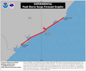
Overall Danny is a fast moving Tropical Storm,and will not impact areas for very long but its formidable enough that caution from any government agency , or from your local National Weather Service Office should be heeded for your personal safety. Due to the potential rainfall, flash flooding can not be ruled out in any of the areas that could be impacted by Tropical Storm Danny. Marine traffic is discouraged along the South Carolina coast as Small Craft Advisories are in effect. Some areas could see as much as 6 to 10 foot waves offshore with a possible 1 to 3 feet of Storm Surge on the South Carolina shores as Danny makes landfall.
The Force Thirteen Team will be providing updates on Tropical Storm Danny though-out the day on Youtube, Twitter, and Facebook. Be sure to check these out for any new and breaking information on Tropical Storm Danny
