Tropical Storm Dolly forms out at Sea; Forecast to Remain over Open Waters

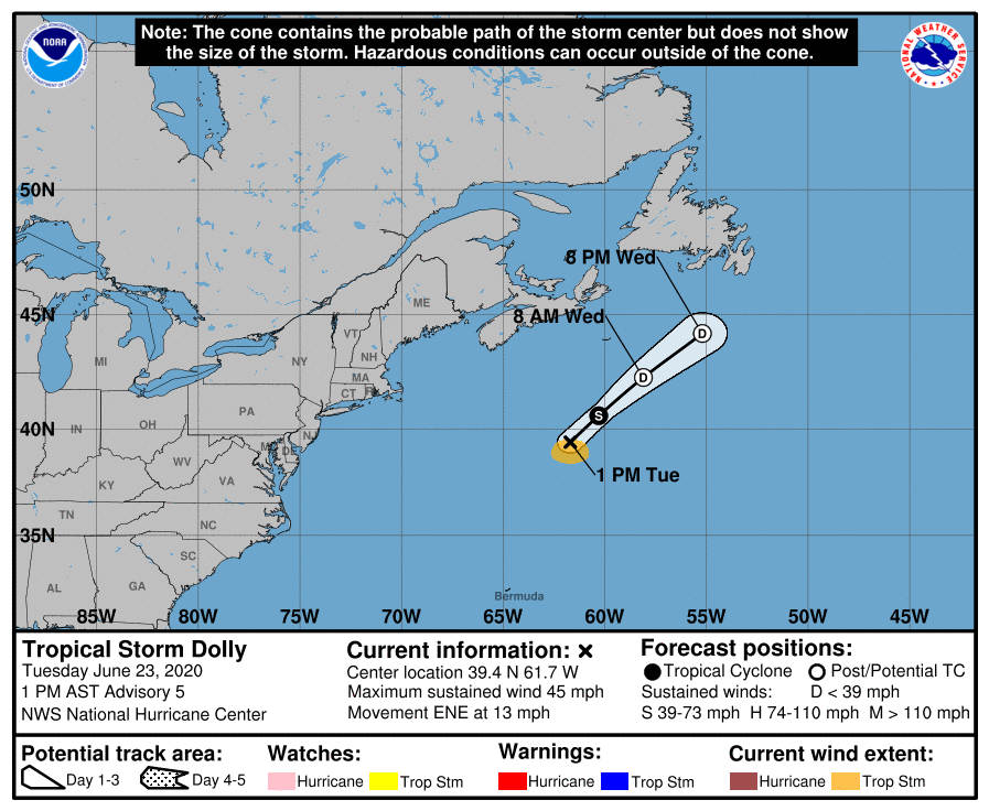
Subtropical Depression Four, which developed yesterday afternoon off the U.S East Coast, has strengthened today and acquired tropical characteristics, and is now Tropical Storm Dolly. It is the fourth named storm of the 2020 Atlantic hurricane season, and the second tropical storm in the North Atlantic this June, after Cristobal earlier in the month. As of the most recent advisory from the National Hurricane Center (NHC) at 5:00 PM AST (21:00 UTC), the center of Tropical Storm Dolly was located near 40.1°N, 61.1°W, about 335 mi (540 km) south-southeast of Halifax, Nova Scotia, and about 605 mi (975 km) southwest of Cape Race, Newfoundland. Maximum sustained winds are near 45 mph (75 km/h) with gusts to 60 mph (95 km/h), and the minimum central pressure is 1002 mb (29.59 inches). The cyclone is moving toward the east-northeast at around 12 mph (19 km/h), and a turn toward the northeast with an increase in forward speed is expected tonight into Wednesday. Dolly is forecast to weaken over the next day or two as it moves over colder waters, and is expected to become post-tropical on Wednesday. Dolly is a small tropical cyclone: tropical storm-force winds extend outward only about 70 miles (110 km), mainly south of the center. Dolly poses no threat to land, and no tropical cyclone watches or warnings are currently in effect.
Tropical Storm Dolly: Forecast Track and Intensity Guidance
While Dolly is still located over the warm Gulf Stream waters and could strengthen a little more this evening, it will be soon be moving over colder waters as it continues northeastward, and model track guidance is in good agreement on the northeastward track and acceleration of the storm. Weakening is expected to begin later today as Dolly moves over cooler waters and into a higher shear environment, which should cause the tropical cyclone to degenerate into a post-tropical remnant low by Wednesday afternoon. The remnant low is forecast to dissipate by Thursday afternoon, although it is entirely possible that the circulation could open up into a trough sooner than that.
Although Dolly is not forecast to impact land, it is a noteworthy storm for several climatological aspects. Dolly’s formation as a subtropical depression at 38.2°N is the northernmost point of formation for any Atlantic tropical cyclone before July 1. Additionally, Dolly is the second-earliest fourth-named storm of an Atlantic hurricane season, alongside Debby in 2012, and behind only Danielle in 2016.
External Links
For more information regarding current activity in the tropics, visit Force Thirteen’s official outlets at the official Force Thirteen YouTube channel, Twitter, and Facebook pages. Tropical Weather Bulletins are posted daily at the Force Thirteen YouTube channel at 00:00 UTC, and Tropical Weather Outlooks can be found at Force Thirteen’s social media outlets.
