Tropical Storm Douglas, Tropical Depression Seven-E form in the Eastern Pacific; North Atlantic Seeing Renewed Activity

Two new tropical cyclones in the Eastern Pacific, Tropical Depression Seven-E and Tropical Storm Douglas, are today’s main headlines, with one on the way out and the other likely to strengthen over the next few days. Tropical Depression Seven-E, which developed yesterday morning, is currently weakening and expected to become a remnant low soon. Tropical Storm Douglas, which has recently been named, is forecast to strengthen over the next few days, and could impact the Hawaiian islands toward the end of the week and over the weekend. In the North Atlantic, three systems are currently being monitored for tropical cyclone formation, two of which are likely to impact the United States Gulf Coast.
Tropical Depression Seven-E: Forecast Track and Intensity Guidance
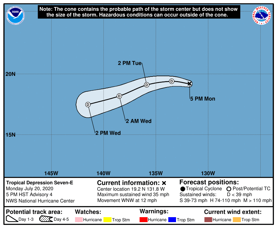
As of the National Hurricane Center’s most recent advisory at 5:00 PM HST (03:00 UTC), the center of Tropical Depression Seven-E is located near 19.2°N, 131.8°W, about 1435 mi (2305 km) west of the southern tip of the Baja California Peninsula. Maximum sustained winds are near 35 mph (55 km/h) with gusts to 45 mph (75 km/h), and the minimum central pressure is 1008 mb (29.77 inches). The depression is moving toward the west-northwest at near 12 mph (19 km/h), and a gradual turn to the west-southwest is expected through today. Weakening is forecast during the next 48 hours, and the depression is forecast to degenerate into a remnant low soon, followed by dissipation on Wednesday. This system is not a threat to land, and no tropical cyclone watches or warnings are in effect.
Tropical Storm Douglas: Forecast Track, Intensity Guidance, and Hazards Affecting Land
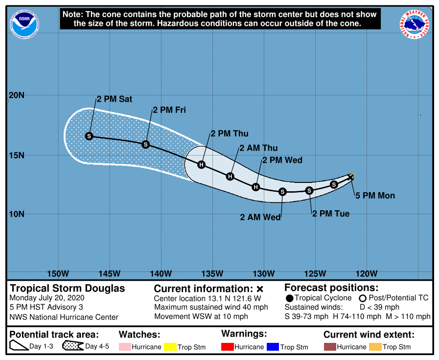
As of the National Hurricane Center’s most recent advisory on Douglas at 5:00 PM HST (03:00 UTC), the center of Tropical Storm Douglas was located near 13.1°N, 121.6°W, about 1025 mi (1645 km) southwest of the southern tip of the Baja California Peninsula. Maximum sustained winds are near 40 mph (65 km/h), gusting to 50 mph (85 km/h), the minimum central pressure is 1006 mb (29.71 inches), and tropical storm-force winds extend outward up to 35 mi (55 km) from the center. Douglas is moving toward the west-southwest at near 10 mph (17 km/h), and a slightly faster, generally westward motion is expected over the next few days. Steady strengthening is forecast during the next few days, and Douglas is expected to become a hurricane by Thursday morning. By the weekend, the system is expected to begin weakening as it encounters a less favorable environment.
Douglas is currently located in and expected to remain in a rather favorable environment. Warm sea surface temperatures, high moisture content, and low vertical wind shear should allow for this compact cyclone to strengthen over the next few days. Numerical model guidance has trended upward this morning, and both the GFS and ECMWF global models strengthen Douglas into a hurricane. Given such a favorable environment, it is even possible that Douglas could undergo a period of rapid intensification sometime within the next few days; the SHIPS Rapid Intensification Index indicates a 25% chance of a 25-kt increase in sustained wind speed during the next 24 hours. The current NHC forecast is near the upper end of the intensity guidance, and brings Douglas to a peak intensity of 85 mph (140 km/h) on Thursday morning before weakening begins on Friday. Later in the forecast period, Douglas could pass close to the Hawaiian islands; the ECMWF model takes the cyclone very close to those islands as a tropical storm over the weekend. However, it is too soon to determine what, if any, impacts Douglas may bring to the Hawaiian islands.
External Links
For more information regarding current activity in the tropics, visit Force Thirteen’s official outlets at the official Force Thirteen YouTube channel, Twitter, and Facebook pages. Tropical Weather Bulletins are posted daily at the Force Thirteen YouTube channel at 00:00 UTC, and Tropical Weather Outlooks can be found at Force Thirteen’s social media outlets.
