Tropical Storm Eloise Threatening Madagascar, High Chance of Strong Winds and Heavy Rain

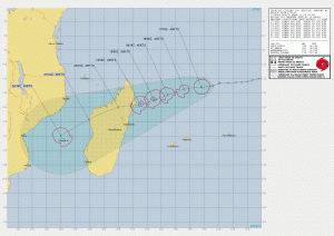
Tropical Storm Eloise is located 806 km north-northeast of Port Louis, Mauritius, and has tracked westward at 30 km/h over the past 6 hours. Infrared satellite imagery shows a symmetric mass of persistent convection which is sheared to the east of the obscured low level circulation center (LLCC).The system is currently tracking along the northern periphery of a deep-layer subtropical ridge centered to the south and this motion is expected to continue through the duration of the forecast period. The system is expected to make landfall just after 2 days along the northeastern coast of Madagascar. Some slight modifications in the track can be expected as the system crosses Madagascar but the overall steering pattern is forecast to remain steady for the duration of the forecast. Sea surface temperatures in the region are warm (28-29°C) but the combination of limited diffluent outflow and moderate wind shear will result in slow intensification over the next 24 to 36 hours.
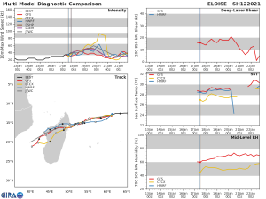
Forecast models are in good agreement with 80 nautical miles spread in 2 days.Maximum significant wave height at 17/18:00 UTC is 15 feet (4.6 meters).
CURRENT INFORMATION:
CURRENT WIND SPEED: 50mph/80kmh
MINIMUM PRESSURE: 995mbar
Information from the Joint Typhoon Warning Center.
